
Geography of Switzerland: Difference between revisions
m →Land Use: add comma for clarity |
→Environment: expanded and removed lists |
||
| Line 76: | Line 76: | ||
==Environment== |
==Environment== |
||
With the delicate alpine and glacial environments making up a significant portion of the country and providing a major industry, Switzerland has been concerned with environmental issues. Some of the main issues are listed below. |
|||
'''[[environment (biophysical)|Environment]] - current issues: |
|||
===Air=== |
===Air=== |
||
The main environmental issues in Switzerland's air is [[air pollution]] from vehicle emissions and open-air burning as well as [[acid rain]]<ref name="CIA Factbook"/>. In 2004, the average amount of [[Carbon Dioxide]] (CO2) emission per resident was 6 tons<ref name="BFS"/> and in 2005 was 6.2 tons<ref name="MDG">[http://mdgs.un.org/unsd/mdg/Data.aspx United Nations Millennium Development Goals Indicators] accessed December 2, 2008</ref>. With these numbers, Switzerland is 31<sup>st</sup> to 33<sup>rd</sup> amoung the 45 nations listed by United Nations Millennium Development Goals Indicators as [[developed nation]]s and 69<sup>th</sup> worldwide<ref name="MDG"/>. |
The main environmental issues in Switzerland's air is [[air pollution]] from vehicle emissions and open-air burning as well as [[acid rain]]<ref name="CIA Factbook"/>. In 2004, the average amount of [[Carbon Dioxide]] (CO2) emission per resident was 6 tons<ref name="BFS"/> and in 2005 was 6.2 tons<ref name="MDG">[http://mdgs.un.org/unsd/mdg/Data.aspx United Nations Millennium Development Goals Indicators] accessed December 2, 2008</ref>. With these numbers, Switzerland is 31<sup>st</sup> to 33<sup>rd</sup> amoung the 45 nations listed by United Nations Millennium Development Goals Indicators as [[developed nation]]s and 69<sup>th</sup> worldwide<ref name="MDG"/>. Switzerland expects by 2010 to reduce their total greenhouse gas emissions by 8% to 10% over emissions in 1990<ref name="HDS Environment"/>. |
||
The population ({{as of|2005|lc=on}}) uses 3.76 [[Tonne of oil equivalent]] per person per year, of which 43.7% comes from [[petroleum]] and 19% from [[nuclear power]]<ref name="BFS"/>. |
The population ({{as of|2005|lc=on}}) uses 3.76 [[Tonne of oil equivalent]] per person per year, of which 43.7% comes from [[petroleum]] and 19% from [[nuclear power]]<ref name="BFS"/>. |
||
===Water=== |
===Water=== |
||
[[ |
The major water issue in Switzerland is [[water pollution]] from the increased use of agricultural fertilizers as well as [[hydrocarbon]] pollution from transport and industry<ref name="CIA Factbook"/>. While inprovements have been made, there are still issues with [[eutrophication]] (an increase in nitrogen and phosphates) in many lakes in the Swiss Plateau<ref name="BFS Environment"/>. |
||
The total renewable [[water resources]] of Switzerland {{as of|2005}} is {{convert|53.3|km3|impgal USgal|abbr=on}}<ref name="CIA Factbook"/>. Of which the total [[freshwater]] withdrawal is {{convert|2.5|km3|impgal USgal|abbr=on}}per year. This breaks down to a [[per capita]] freshwater withdrawal of {{convert|348|m3|impgal USgal|abbr=on}} per year. Of that water({{as of|2002|lc=on}}), 24% is used for in households, 74% in industry and only 2% is used for agriculture<ref name="CIA Factbook"/>. |
|||
*Total renewable water resources: {{convert|53.3|km3|impgal USgal|abbr=on}} (2005)<ref name="CIA Factbook"/> |
|||
*Freshwater withdrawal: {{convert|2.5|km3|impgal USgal|abbr=on}}/year |
|||
*per capita [[freshwater]] withdrawal: {{convert|348|m3|impgal USgal|abbr=on}}/year |
|||
**Domestic: 24% |
|||
**Industrial: 74% |
|||
**Agricultural: 2% (2002)<ref name="CIA Factbook"/> |
|||
===Biodiversity=== |
===Biodiversity=== |
||
Switzerland is facing a loss of [[biodiversity]]<ref name="CIA Factbook"/>. While the country is quite small, the wide range of climates allow a variety of organisms to flourish. There are about 50,000 animal and plant species living in Switzerland<ref name="BFS Environment"/>. While most species that live on north and south foothills of the Alps are generally doing well, the Swiss Plateau is seeing a decrease in many species. The pressure from city and agricultural growth is reducing or eliminating the habitat of many species that once flourished along the plateau. There are about 60 species that are considered endangered that live in Switzerland<ref name=BFS Environment"/>. To help offset this, 28.6% of the country is set aside as a protected natural area<ref name="MDG"/>. |
|||
Switzerland is facing a loss of [[biodiversity]]<ref name="CIA Factbook"/>. 28.6% of the country is set aside as a protected natural area<ref name="MDG"/>. |
|||
===International agreements=== |
===International agreements=== |
||
Revision as of 00:18, 4 December 2008


Switzerland is a small, generally mountainous and landlocked country located in the center of Europe. It has a total area of about Template:Km2 to mi2 of which Template:Km2 to mi2 is land and Template:Km2 to mi2 is water. Switzerland is landlocked and surrounded by Austria (Template:Km to mi) and Liechtenstein (Template:Km to mi) to the east, France (Template:Km to mi) to the west, Italy (Template:Km to mi) to the south and Germany (Template:Km to mi) to the north. It is one of the smallest countries in Europe, with a maximum north-south length of Template:Km to mi and an east-west length of about Template:Km to mi[1].
Switzerland is well known for the Alps in the south and south east. North of the Alps, the Swiss plateau runs along the east-west axis of the country. Most of the population of Switzerland lives on the rolling hills and plains of the plateau. The smaller Jura Mountains are located on the north west side of the plateau. Much of the northern border with Germany follows the Rhine River, though the Rhine enters Switzerland near Schaffhausen. The eastern border with Germany and a portion of Austria is drawn through Lake Constance (German: Bodensee). A portion of the southwest border with France is drawn through Lake Geneva.
Switzerland is divided into 23 cantons, 3 of which are further divided into half cantons (Obwalden/Nidwalden, Basel Stadt/Basel Land, Appenzell Ausserrhoden/Appenzell Innerrhoden). The cantons along the Swiss plateau tend to be the most populous,[2] industrial and religiously Protestant.[3] The cantons in the Alps tend to be less populous, agrarian or tourist based economies, and religiously Catholic.[3]
Switzerland is also divided by language. There are four official languages; German 63.7% of population, French 20.4% of population, Italian 6.5% of population and Romansh 0.5% of population[4]. From Berne east (except Ticino) the population generally speaks German. West of Berne, the population generally speaks French. In the southern Canton of Ticino, most people speak Italian. Romansh, a group of dialects descended from Vulgar Latin, is spoken in several regions in the canton of Graubunden.
Regions
Swiss Plateau
.jpg)

The Swiss Plateau runs from Lake Geneva on the French Border across central Switzerland to Lake Constance on the German and Austrian Borders. The plateau has an average altitude of Template:M to ft[5]. The entire plateau is covered with rolling hills, small lakes and rivers. Most of Switzerland's large lakes are located in the plateau. Both Lake Geneva (Template:Km2 to mi2) and Lake Constance (Template:Km2 to mi2) are located in the plateau but are shared with other countries. The largest lake totally in Switzerland, Lake Neuchâtel (Template:Km2 to mi2), is located in the Swiss Plateau.
The Swiss Plateau is crossed by three great river valleys (Rhone, Rhine and Aar) with the smaller Thur River valley. While the head waters of these four rivers all lie in the Alps, they all cut across the plateau between the Alps and the Jura mountains. The Rhone and Rhine valleys are shut off from that of the Aar and the isolated Thur by the great northern outlier of the Alps, which consists of the Bernese Oberland and Glarus Alps. Two wide and undulating valleys (Aar and Thur) and two deeply cut trenches (Rhone and Rhine) thus lie on the northern slope of the Alps, to the north and south respectively of the great northern outlier of the Alps.[6] All four rivers wind back and forth and combine to form some of the major rivers in Europe. Near Schaffhausen the Rhine River passes through the Rhine Falls, Europe's largest waterfall. The Rhine Falls are Template:M to ft wide and Template:M to ft.
The plateau occupies about one third of the land area in Switzerland and about two thirds of the population live in this area. The population density on the plateau averages about 450 people per km2 (1,166 per square mile)[5]. In the regions around Lake Geneva, Lake Zürich and other cities, the population density exceeds 1000 people per km2.[7] In addition to a majority of the population, the Swiss Plateau is also home to the majority of industry, manufacturing and farming in Switzerland. The farms are generally small and very organized. Most farms include small meadows alternating with fields filled with a variety of crops and with small wooded areas.
The Swiss Alps
- Main article: Swiss Alps
- See also: Geography of the Alps

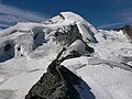
The Swiss Alps form part of a chain of mountains that stretch across southern Europe and isolate Northern Europe from the Mediterranean Sea. Several important passes through the Alps are located in Switzerland, and control of the passes has been important throughout Switzerland's history. The Alps have an average altitude of Template:M to ft[8] and cover nearly two thirds of the total surface area. Within the Alps there are 48 mountains that are Template:M to ft or higher.
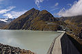
The Alps are the watershed of Western Europe. The Rhine River, together with its tributaries the Aare River and the Thur River drain about two thirds of the water into the North Sea. The Rhone and the Ticino drain about 18% of the water into the Mediterranean Sea. The Inn which becomes the Danube outside of Switzerland drains about 4.4% of the water into the Black Sea[9]. The Swiss Alps also contain many of Central Europe's glaciers. There are about 1,800 glaciers[8] which cover Template:Km2 to mi2 of the total glaciated area of the Alps.
The Alps are a popular tourist destination and are one of the most recognizable symbols of Switzerland. The tallest point in Switzerland, Dufourspitze (Template:M to ft) in Canton Valais, is located in the Alps as is tallest mountain wholly in Switzerland, the Dom (Template:M to ft). One of the most recognizable symbols of Switzerland, the Matterhorn is also located in the Alps. The Matterhorn (Template:M to ft) is the seventh highest peak in the Swiss Alps and is the most photographed mountain in Switzerland. The tallest mountain in the northern outlier[6] or Bernese Alps is the Finsteraarhorn (Template:M to ft.
On the south face of the Alps is the canton of Ticino which is split geographically in two parts by the Monte Ceneri pass. The northern, more mountainous part, called Sopraceneri, is formed by the two major Swiss valleys around the lake Maggiore: Ticino valley and Maggia valley. The southern part, called Sottoceneri, is the region around the Lake Lugano. The lowest point in Switzerland is on Lake Maggiore (Template:M to ft).[6]
The Jura

The Jura is a limestone range running from Lake Geneva to the Rhine river. This area makes up about 12% of Switzerland's land area. Located about Template:M to ft above sea level, this region is characterized by a limestone highland with deep river valleys.
The limestone rock in the Jura is a Jurassic period rock with numerous fossils and dinosaur tracks. The name Jurassic actually refers to the Jura region where these fossils were studied at the end of the 18th Century[10]. The Jura is considered one of the most important sites for dinosaur footprints in the world. In one area near the village of Courtedoux, over 1,500 footprints were discovered in between 2002 and 2004 with an estimated 4,000-5,000 footprints still undiscovered[11]
The range is being continually built up and decreasing in width by mountain building, accommodating the compression from alpine folding as the main Alpine orogenic front moves roughly northwards. The deformation becomes less pervasive away from the younger, more active Alpine mountain building.
Structurally, the Jura consists of a sequence of folds, the formation of which is facilitated by an evaporitic decollement layer. The box folds are still relatively young, and this is evident in that they define the shape of the overlying landscape, meaning that they have not existed long enough to experience erosion and thus are evidence of recent mountain building.
The folds comprise three major (lithological units) bands of building evidenced dated roughly by era: the Malm, Dogger, and Lias (part of the Jurassic Geologic period). Each era of folding represents effects on a previously shallow marine environment as evidenced by beds with particular carbonate sequences, containing abundant bioclasts and oolitic divisions between layers (called horizons).
The highest peak in the Jura range is Le Crêt de la Neige at Template:M to ft, although previously it was believed to be Template:M to ft. This could be caused by constant Tectonic Plate movements making such mountain ranges go higher.
Climate
The weather in Switzerland is generally moderate in the Swiss Plateau. On the plateau, freezing temperatures generally occur during December-early March[12] with an average temperature of Template:C to F for elevations between 500–600 metres (1,600–2,000 ft). On the Plateau the average precipitation is Template:Mm to in with a range of about 800–1,300 millimetres (31–51 in)[1]. The higher elevations of the Jura and the Alps naturally cause lower temperatures and in the high Alps glaciers exist. The Jura and foothills (both north and south of the Alps) typically have move precipitation, with an average of 1,200–1,600 millimetres (47–63 in), while the high Alps may have over 2,500 millimetres (98 in)[1]. Ticino, on the south side of the Alps, has sub-tropical vegetation and is usually 2-4°C (4-7° F) warmer and wetter than the Swiss Plateau.
In the Köppen climate classification, the Swiss Plateau is classed as Maritime Temperate or Oceanic climate (Cfb) and the Alps are considered Tundra climates or (ET). A maritime temperate area will have changeable, often overcast weather. Summers are cool due to cloud cover and winters are milder than expected due to latitude. The Jura will be slightly cooler due to higher altitude. Within the Alps, temperatures and snow fall correlate to altitude.
Land Use
As of 2001[update], 36.9%[13] of the land in Switzerland was used for farming. In 1993 it was estimated that Template:Km2 to mi2 (or about 0.6%) of the entire country was irrigated[4] meaning that most Swiss farms receive enough rainfall to grow. 30.8% of the country is covered with forests and woodlands[13], with an additional 6.8% covered with houses or buildings[1]. About one-fourth (25.5%) of the country is either mountains, lakes or rivers and can not be used[1].
Environment
With the delicate alpine and glacial environments making up a significant portion of the country and providing a major industry, Switzerland has been concerned with environmental issues. Some of the main issues are listed below.
Air
The main environmental issues in Switzerland's air is air pollution from vehicle emissions and open-air burning as well as acid rain[4]. In 2004, the average amount of Carbon Dioxide (CO2) emission per resident was 6 tons[13] and in 2005 was 6.2 tons[14]. With these numbers, Switzerland is 31st to 33rd amoung the 45 nations listed by United Nations Millennium Development Goals Indicators as developed nations and 69th worldwide[14]. Switzerland expects by 2010 to reduce their total greenhouse gas emissions by 8% to 10% over emissions in 1990[15].
The population (as of 2005[update]) uses 3.76 Tonne of oil equivalent per person per year, of which 43.7% comes from petroleum and 19% from nuclear power[13].
Water
The major water issue in Switzerland is water pollution from the increased use of agricultural fertilizers as well as hydrocarbon pollution from transport and industry[4]. While inprovements have been made, there are still issues with eutrophication (an increase in nitrogen and phosphates) in many lakes in the Swiss Plateau[1].
The total renewable water resources of Switzerland As of 2005[update] is 53.3 km3 (1.17×10¹³ imp gal; 1.41×10¹³ US gal)[4]. Of which the total freshwater withdrawal is 2.5 km3 (5.5×10¹¹ imp gal; 6.6×10¹¹ US gal)per year. This breaks down to a per capita freshwater withdrawal of 348 m3 (77,000 imp gal; 92,000 US gal) per year. Of that water(as of 2002[update]), 24% is used for in households, 74% in industry and only 2% is used for agriculture[4].
Biodiversity
Switzerland is facing a loss of biodiversity[4]. While the country is quite small, the wide range of climates allow a variety of organisms to flourish. There are about 50,000 animal and plant species living in Switzerland[1]. While most species that live on north and south foothills of the Alps are generally doing well, the Swiss Plateau is seeing a decrease in many species. The pressure from city and agricultural growth is reducing or eliminating the habitat of many species that once flourished along the plateau. There are about 60 species that are considered endangered that live in Switzerland[13]. To help offset this, 28.6% of the country is set aside as a protected natural area[14].
International agreements
Party to:
- Air Pollution
- Air Pollution-Nitrogen Oxides
- Air Pollution-Sulphur 85, Air Pollution-Sulphur 94
- Air Pollution-Volatile Organic Compounds
- Air Pollution-Persistent Organic Pollutants
- Antarctic Treaty
- Biodiversity
- Climate Change
- Desertification
- Endangered Species
- Environmental Modification
- Hazardous Wastes
- Marine Dumping
- Marine Life Conservation
- Nuclear Test Ban
- Ozone Layer Protection
- Ship Pollution
- Tropical Timber 83
- Tropical Timber 94
- Wetlands
- Whaling
Signed, but not ratified:
Gallery
-
View of the Matterhorn from Riffelalp Valais
-

-

-

-
 The United Nations in Geneva
 -
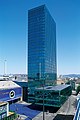 Messeturm in Basel
 -
-
-
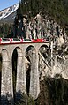 The Glacier Express
 -

-

-
 Mittel Allalin in Saas Fee
 -

-
-
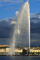 The Jet d'eau in Geneva
 -
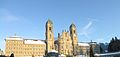 The Einsiedeln Abbey
 -
 The lake of Oeschinen
 -
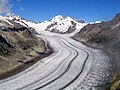 The Aletsch Glacier
 -
 The three castles of Bellinzona
 -
 View from Klein Matterhorn
 -

-
 Stockalper Castle in Brig
 -
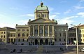
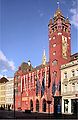 City Hall of Basel
 -
 The North face of Dent Blanche
 -
-


Topography
- List of islands of Switzerland
- List of lakes in Switzerland
- List of mountain ranges in Switzerland
- List of mountains in Switzerland
- List of mountain passes in Switzerland
- List of rivers of Switzerland
- List of glaciers in Switzerland
- Extreme points of Switzerland
- Geographical centre of Switzerland
See also
External links
References
- ^ a b c d e f g Bundesamt fur Statistik (Federal Department of Statistics) (2008). "Land and Environment" (PDF). Retrieved 2008-12-03. Template:De icon Template:Fr icon
- ^ Switzerland: Statistical information
- ^ a b Swiss Federal Statistics Office, in German
- ^ a b c d e f g h CIA - The World Factbook - Switzerland
- ^ a b The Swiss Plateau - Switzerland - Information
- ^ a b c "Switzerland". Encyclopædia Britannica. Vol. 26. 1911. pp. 239–40. Retrieved 2008-11-12.
- ^ Swiss Federal Statistics Office Map Template:De icon
- ^ a b The Alps - Switzerland - Information
- ^ Geography of Switzerland
- ^ The Jura - Switzerland - Information
- ^ Swissinfo article, August 26, 2004
- ^ Weather - Switzerland Tourism
- ^ a b c d e Bundesamt fur Statistik (Federal Department of Statistics) (2008). "Statistics for Switzerland". Retrieved 2008-12-01. Template:De icon
- ^ a b c United Nations Millennium Development Goals Indicators accessed December 2, 2008
- ^ Cite error: The named reference
HDS Environmentwas invoked but never defined (see the help page).