
Geography of Switzerland: Difference between revisions
m →The Jura: replace wre with were |
|||
| Line 34: | Line 34: | ||
==Climate== |
==Climate== |
||
The weather in Switzerland is generally moderate in the Swiss Plateau. On the plateau, freezing temperatures generally occur during [[December]]-early [[March]]<ref>http://www.myswitzerland.com/en.cfm/about_switzerland/weather</ref>. The higher elevations of the Jura and the Alps naturally cause lower temperatures and in the high Alps glaciers exist. Ticino, on the south side of the Alps, has sub-tropical vegetation and is usually 2-4°[[Celsius|C]] (4-7° [[Fahrenheit|F]]) warmer than the Swiss Plateau. |
|||
'''[[Climate]]:''' temperate, but varies with altitude; cold, cloudy, rainy/snowy winters; cool to warm, cloudy, humid summers with occasional showers |
|||
In the [[Köppen climate classification]], the Swiss Plateau is classed as Maritime Temperate or [[Oceanic climate]] ('''Cfb''') and the Alps are considered [[Tundra]] climates or ([[Alpine climate|ET]]). A maritime temperate area will have changeable, often overcast weather. Summers are cool due to cloud cover and winters are milder than expected due to latitude. The Jura will be slightly cooler due to higher altitude. Within the Alps, temperatures and snow fall correlate to altitude. |
|||
==Land Use== |
==Land Use== |
||
Revision as of 23:34, 6 December 2007


Switzerland is a small, generally mountainous and landlocked country located in the center of Europe. It has a total area of about 41'290 km² or 15,942 mi2 of which 39'770 km² (15,355 mi2) is land and 1'520 km² (587 mi2) is water. Switzerland is landlocked and surrounded by Austria (164 km) and Liechtenstein (41 km) to the east, France (573 km) to the west, Italy (740 km) to the south and Germany (334 km) to the north.
Switzerland is well known for the Alps in the south and south east. North of the Alps, the Swiss plateau runs along the east-west axis of the country. Most of the population of Switzerland lives on the rolling hills and plains of the plateau. The smaller Jura Mountains are located on the north west side of the plateau. Much of the northern border with Germany follows the Rhine River, though the Rhine enters Switzerland near Schaffhausen. The eastern border with Germany and a portion of Austria is drawn through Lake Constance (German:Bodensee). A portion of the south west border with France is drawn through Lake Geneva.
Switzerland is divided into 23 cantons, 3 of which are further divided into half cantons (Obwalden/Nidwalden, Basel Stadt/Basel Land, Appenzell Ausserrhoden/Appenzell Innerrhoden). The cantons along the Swiss plateau tend to be the most populated[1], industrial and religiously Protestant[2]. The cantons in the Alps tend to be less populated, agrarian or tourist based economies, and religiously Catholic[1].
Switzerland is also divided by language. There are four official languages; German 63.7% of population, French 20.4% of population, Italian 6.5% of population and Romansh 0.5% of population[3]. From Berne east (except Ticino the population will generally speak German. West of Berne, the population will generally speak French. In the southern Canton of Ticino most people will speak Italian. Romansh, a variety of dialects descended from Vulgar Latin, is spoken in several regions in the canton of Graubunden.
Regions
Swiss Plateau
.jpg)

The Swiss Plateau runs from Lake Geneva on the French Border across central Switzerland to Lake Constance on the German and Austrian Borders. The plateau has an average altitude of 580m (1902 ft)[4]. The entire plateau is covered with rolling hills, small lakes and rivers. Most of Switzerland's large lakes are located in the plateau. Both Lake Geneva (581.3 km2) and Lake Constance (541.1 km2) are located in the plateau but are shared with other countries. The largest lake totally in Switzerland, Lake Neuchâtel (218.3 km2), is located in the Swiss Plateau. Most of Switzerland's rivers start in the Alps, but every north flowing river will cross the plateau. On the plateau, rivers wind back and forth and combine to form some of the major rivers in Europe. Near Schaffhausen the Rhine River passes through the Rhine Falls, Europe's largest waterfall. The Rhine Falls are 150 m (450 ft) wide and 25 m (80 ft) high.
The plateau occupies about one third of the land area in Switzerland and about two thirds of the population live in this area. The population density on the plateau averages about 450 people per km2 (1,166 per square mile)[2]. In the regions around Lake Geneva, Lake Zurich and other cities, the population density exceeds 1000 people per km2[5]. In addition to a majority of the population, the Swiss Plateau is also home to the majority of industry, manufacturing and farming in Switzerland. The farms are generally small and very organized. Most farms include small meadows alternating with fields filled with a variety of crops and with small wooded areas.
The Swiss Alps

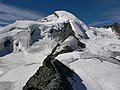
The Swiss Alps form part of a chain of mountains that stretch across southern Europe and isolate Northern Europe from the Mediterranean Sea. Several important passes through the Alps are located in Switzerland, and control of the passes has been important throughout Switzerland's history. The Alps have an average altitude of 1700m (5576 ft)[6] and cover nearly two thirds of the total surface area. Within the Alps there are 48 mountains that are 4000m (13,120 ft) or higher.
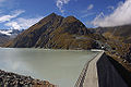
The Alps are the watershed of Western Europe. The Rhine River, together with its tributaries the Aare and the Thur drain about two thirds of the water into the North Sea. The Rhone and the Ticino drain about 18% of the water into the Mediterranean Sea. The Inn which becomes the Danube outside of Switerland drains about 4.4% of the water into the Black Sea[7]. The Alps also contain many of Central Europe's glaciers. There are about 1,800 glaciers[3] which cover about 3,000 km2 of the Alps[8].
The Alps are a popular tourist destination and are one of the most recognizable symbols of Switzerland. The tallest point in Switzerland, Dufourspitze (4634 m or 15203 ft) in Canton Valais, is located in the Alps. Another symbol of Switzerland, the Matterhorn is also located in the Alps. The Matterhorn (4,478 m or 14691 ft) is the seventh highest peak in the Swiss Alps and is the most photographed mountain in Switzerland.
The Jura

The Jura is a limestone range running from Lake Geneva to the Rhine river. This area makes up about 12% of Switzerland's land area. Located about 700 m (2,300 ft) above sea level, this region is characterized by a limestone highland with deep river valleys.
The limestone rock in the Jura is a Jurassic period rock with numerous fossils and dinosaur tracks. The name Jurassic actually refers to the Jura region where these fossils were studied at the end of the 18th Century[9]. The Jura is considered one of the most important sites for dinosaur footprints in the world. In one area near the village of Courtedoux, over 1,500 footprints were discovered in between 2002 and 2004 with an estimated 4,000-5,000 footprints still undiscovered[10]
Climate
The weather in Switzerland is generally moderate in the Swiss Plateau. On the plateau, freezing temperatures generally occur during December-early March[11]. The higher elevations of the Jura and the Alps naturally cause lower temperatures and in the high Alps glaciers exist. Ticino, on the south side of the Alps, has sub-tropical vegetation and is usually 2-4°C (4-7° F) warmer than the Swiss Plateau.
In the Köppen climate classification, the Swiss Plateau is classed as Maritime Temperate or Oceanic climate (Cfb) and the Alps are considered Tundra climates or (ET). A maritime temperate area will have changeable, often overcast weather. Summers are cool due to cloud cover and winters are milder than expected due to latitude. The Jura will be slightly cooler due to higher altitude. Within the Alps, temperatures and snow fall correlate to altitude.
Land Use
- arable land: 10%
- permanent crops: 2%
- permanent pastures: 28%
- forests and woodland:32%
- other:28% (1993 est.)
Irrigated land: 250 km² (1993 est.)
Environment
Environment - current issues: air pollution from vehicle emissions and open-air burning; acid rain; water pollution from increased use of agricultural fertilizers; loss of biodiversity
Environment - international agreements:
party to:
Air Pollution,
Air Pollution-Nitrogen Oxides,
Air Pollution-Sulphur 85, Air Pollution-Sulphur 94,
Air Pollution-Volatile Organic Compounds,
Air Pollution-Persistent Organic Pollutants,
Antarctic Treaty,
Biodiversity,
Climate Change,
Desertification,
Endangered Species,
Environmental Modification,
Hazardous Wastes,
Marine Dumping,
Marine Life Conservation,
Nuclear Test Ban,
Ozone Layer Protection,
Ship Pollution,
Tropical Timber 83,
Tropical Timber 94,
Wetlands,
Whaling
signed, but not ratified:
Antarctic-Environmental Protocol,
Climate Change-Kyoto Protocol,
Law of the Sea
Gallery
This section contains an unencyclopedic or excessive gallery of images. |
-
View of the Matterhorn from Riffelalp Valais
-

-

-

-
 The United Nations in Geneva
 -
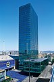 Messeturm in Basel
 -
-
-
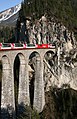 The Glacier Express
 -

-

-
 Mittel Allalin in Saas Fee
 -

-
-
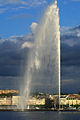 The Jet d'eau in Geneva
 -
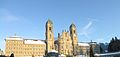 The Einsiedeln Abbey
 -
 The lake of Oeschinen
 -
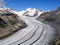 The Aletsch Glacier
 -
 The three castles of Bellinzona
 -
 View from Klein Matterhorn
 -

-
 Stockalper Castle in Brig
 -
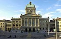
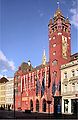 City Hall of Basel
 -
 The North face of Dent Blanche
 -
-


Topography
- List of islands of Switzerland
- List of lakes in Switzerland
- List of mountain ranges in Switzerland
- List of mountain passes in Switzerland
- List of rivers of Switzerland
- List of glaciers in Switzerland
- Extreme points of Switzerland
- Geographical centre of Switzerland
See also
External Links
References
- ^ http://www.about.ch/statistics/index.html
- ^ Swiss Federal Statistics Office, in German
- ^ https://www.cia.gov/library/publications/the-world-factbook/geos/sz.html
- ^ http://www.swissworld.org/en/geography/the_three_regions/the_swiss_plateau/
- ^ Swiss Federal Statistics Office Map, in German
- ^ http://www.swissworld.org/en/geography/the_three_regions/the_alps/
- ^ http://www.about.ch/geography/index.html#CH_Geo_Rivers
- ^ http://www.about.ch/geography/index.html#CH_Geo_Glaciers
- ^ http://www.swissworld.org/en/geography/the_three_regions/the_jura/
- ^ Swissinfo article, August 26, 2004
- ^ http://www.myswitzerland.com/en.cfm/about_switzerland/weather