
Senja Municipality
Senja Municipality
Senja kommune | |
|---|---|
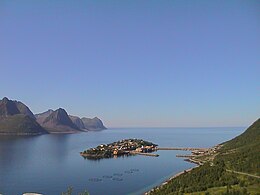
 View of Finnsnes in Senja | |
 Coat of arms | |
 Troms within Norway | |
 Senja within Troms | |
| Coordinates: 69°04′50″N 16°48′11″E / 69.0806°N 16.8031°E | |
| Country | Norway |
| County | Troms |
| District | Hålogaland |
| Established | 1 Jan 2020 |
| • Preceded by | Berg, Tranøy, Torsken, and Lenvik |
| Administrative centre | Finnsnes |
| Government | |
| • Mayor (2023) | Geir-Inge Sivertsen (H) |
| Area | |
| • Total | 1,946.09 km2 (751.39 sq mi) |
| • Land | 1,860.90 km2 (718.50 sq mi) |
| • Water | 85.19 km2 (32.89 sq mi) 4.4% |
| • Rank | #40 in Norway |
| Highest elevation | 1,202.4 m (3,944.9 ft) |
| Population (2024) | |
| • Total | 14,894 |
| • Rank | #83 in Norway |
| • Density | 7.7/km2 (20/sq mi) |
| • Change (10 years) | |
| Demonyms | Senjaværing Senjeværing[2] |
| Official language | |
| • Norwegian form | Neutral |
| Time zone | UTC+01:00 (CET) |
| • Summer (DST) | UTC+02:00 (CEST) |
| ISO 3166 code | NO-5530[4] |
| Website | Official website |
Senja is a municipality in Troms county, Norway. It was established on 1 January 2020 when the municipalities of Berg, Lenvik, Torsken, and Tranøy were merged into one municipality. It is located in the traditional district of Hålogaland. The administrative centre of the municipality is the town of Finnsnes. Some of the notable villages in Senja include Å, Aglapsvik, Bjorelvnes, Botnhamn, Finnsæter, Fjordgård, Flakstadvåg, Gibostad, Gryllefjord, Husøy, Langnes, Laukhella, Lysnes, Medby, Mefjordvær, Rossfjordstraumen, Sandbakken, Senjahopen, Silsand, Skaland, Skrollsvika, Stonglandseidet, Torsken, and Vangsvik.
The municipality includes all of the island of Senja, the smaller surrounding islands, and part of the mainland between the Gisundet strait and the Malangen fjord.[5] The 1,946-square-kilometre (751 sq mi) municipality is the 40th largest by area out of the 357 municipalities in Norway. Senja is the 83rd most populous municipality in Norway with a population of 14,894. The municipality's population density is 87.7 inhabitants per square kilometre (227/sq mi) and its population has increased by 0.2% over the previous 10-year period.[6][7]
General information
In March 2017, the Parliament of Norway voted to merge the municipalities of Berg, Lenvik, Torsken, and Tranøy. The new municipality was established on 1 January 2020 as Senja Municipality (Norwegian: Senja kommune).[8][9]
On 1 January 2024, the large Troms og Finnmark county was divided and the municipality became part of the newly re-created Troms county.[10]
Etymology
The Old Norse form of the name must also have been Senja or perhaps Sændja. The meaning of the name is unknown, but it might be related to the verb sundra which means to "tear" or "split apart", possibly because the west coast of the island is torn and split by numerous small fjords. It might also be derived from a Proto-Norse form of the word Sandijōn meaning "(area) of sand" or "sandy island".[11][5]
Coat of arms
The coat of arms was approved for use starting on 1 January 2020. The blazon is "Azure, northern lights vert over mountain peaks argent to sinister" (Norwegian: I mørkeblått grønt nordlys oppe og sølv fjell nede heraldisk venstre). This means the arms have a dark blue field (background) and the charge is the green northern lights above some mountain peaks. The mountain peaks have a tincture of argent which means they are commonly colored white, but if it is made out of metal, then silver is used. The mountain peak is a depiction of the Okshornan mountain.[12][13][14]
Churches
The Church of Norway has four parishes (sokn) within Senja Municipality. It is part of the Senja prosti (deanery) in the Diocese of Nord-Hålogaland.
| Parish (sokn) | Church name | Location of the church | Year built |
|---|---|---|---|
| Berg | Berg Church | Skaland | 1955 |
| Finnsæter Chapel | Finnsæter | 1982 | |
| Mefjordvær Chapel | Mefjordvær | 1916 | |
| Lenvik | Finnsnes Church | Finnsnes | 1979 |
| Lenvik Church | Bjorelvnes | 1879 | |
| Rossfjord Church | Rossfjordstraumen | 1822 | |
| Fjordgård Chapel | Fjordgård | 1976 | |
| Gibostad Chapel | Gibostad | 1939 | |
| Husøy Chapel | Husøy i Senja | 1957 | |
| Lysbotn Chapel | Lysnes | 1970 | |
| Sandbakken Chapel | Sandbakken | 1974 | |
| Torsken | Torsken Church | Torsken | 1784 |
| Flakkstadvåg Chapel | Flakstadvåg | 1925 | |
| Gryllefjord Chapel | Gryllefjord | 1902 | |
| Medby Chapel | Medby | 1890 | |
| Tranøy | Stonglandet Church | Stonglandseidet | 1896 |
| Tranøy Church | Tranøya | 1775 | |
| Skrolsvik Chapel | Skrollsvika | 1924 | |
| Vangsvik Chapel | Vangsvik | 1975 |
Government
Senja Municipality is responsible for primary education (through 10th grade), outpatient health services, senior citizen services, welfare and other social services, zoning, economic development, and municipal roads and utilities. The municipality is governed by a municipal council of directly elected representatives. The mayor is indirectly elected by a vote of the municipal council.[15] The municipality is under the jurisdiction of the Nord-Troms og Senja District Court and the Hålogaland Court of Appeal.
Municipal council
The municipal council (Kommunestyre) of Senja is made up of 45 representatives that are elected to four year terms. The tables below show the current and historical composition of the council by political party.
| Party name (in Norwegian) | Number of representatives | |
|---|---|---|
| Labour Party (Arbeiderpartiet) | 7 | |
| Progress Party (Fremskrittspartiet) | 3 | |
| Conservative Party (Høyre) | 7 | |
| Industry and Business Party (Industri‑ og Næringspartiet) | 3 | |
| Christian Democratic Party (Kristelig Folkeparti) | 1 | |
| Centre Party (Senterpartiet) | 3 | |
| Socialist Left Party (Sosialistisk Venstreparti) | 3 | |
| Senja List (Senjalista) | 4 | |
| Total number of members: | 31 | |
| Party name (in Norwegian) | Number of representatives | |
|---|---|---|
| Labour Party (Arbeiderpartiet) | 13 | |
| Progress Party (Fremskrittspartiet) | 3 | |
| Green Party (Miljøpartiet De Grønne) | 1 | |
| Conservative Party (Høyre) | 8 | |
| Christian Democratic Party (Kristelig Folkeparti) | 1 | |
| Centre Party (Senterpartiet) | 11 | |
| Socialist Left Party (Sosialistisk Venstreparti) | 2 | |
| Senja List (Senjalista) | 6 | |
| Total number of members: | 45 | |
| Note: This municipality was established on 1 January 2020 upon the merger of Berg Municipality, Lenvik Municipality, Torsken Municipality, and Tranøy Municipality. | ||
Mayors
The mayor (Norwegian: ordfører) of Senja is the political leader of the municipality and the chairperson of the municipal council. Here is a list of people who have held this position:
- 2020-2023: Tom-Rune Eliseussen (Sp)
- 2023-present: Geir-Inge Sivertsen (H)[18]
Geography

Senja Municipality is located along the Troms county coast. The municipality encompasses the whole island of Senja, plus some smaller areas on the mainland around the Gisundet strait and the around the Rossfjordvatnet lake. The island is connected to the mainland by the Gisund Bridge. The northern coasts of the island of Senja faces the open sea, the western coast faces the islands of Andøya and Krøttøya, the southern coast faces the islands of Andørja and Dyrøya. On the western coast, steep and rugged mountains rise straight from the sea, with some fishing villages (like Gryllefjord, Husøy) tucked into the small lowland areas between the mountains and the sea. The eastern and southern parts of the island are milder, with rounder mountains, forests, rivers and agriculture land. The highest point in the municipality is the 1,202.4-metre (3,945 ft) tall mountain Vassbruntinden which lies on the border of Senja Municipality and Målselv Municipality.[1]
The municipality is located to the southwest of Tromsø Municipality; west of Balsfjord Municipality; northwest of Målselv Municipality; north of Sørreisa Municipality, Dyrøy Municipality, and Ibestad Municipality; and east of Harstad Municipality and Andøy Municipality. All of these neighboring municipalities are separated from Senja by water except for a land border with Målselv Municipality and Sørreisa Municipality.
Climate
Climate data from the village of Gibostad on the eastern shore of the island, facing the mainland during the base period of 1961–1990. The western side of the island, facing the Norwegian Sea, will have slightly milder but more windy winters.
| Climate data for Gibostad, Lenvik | |||||||||||||
|---|---|---|---|---|---|---|---|---|---|---|---|---|---|
| Month | Jan | Feb | Mar | Apr | May | Jun | Jul | Aug | Sep | Oct | Nov | Dec | Year |
| Mean daily maximum °C (°F) | −1.9 (28.6) |
−1.8 (28.8) |
0.2 (32.4) |
3.6 (38.5) |
8.4 (47.1) |
12.9 (55.2) |
15.0 (59.0) |
14.6 (58.3) |
10.5 (50.9) |
5.8 (42.4) |
1.5 (34.7) |
−0.7 (30.7) |
5.7 (42.3) |
| Daily mean °C (°F) | −4.4 (24.1) |
−4.2 (24.4) |
−2.3 (27.9) |
1.0 (33.8) |
5.5 (41.9) |
9.7 (49.5) |
12.3 (54.1) |
11.6 (52.9) |
7.5 (45.5) |
3.3 (37.9) |
−0.8 (30.6) |
−3.2 (26.2) |
3.0 (37.4) |
| Mean daily minimum °C (°F) | −7.1 (19.2) |
−7.0 (19.4) |
−5.5 (22.1) |
−2.1 (28.2) |
2.5 (36.5) |
6.8 (44.2) |
9.1 (48.4) |
8.3 (46.9) |
5.1 (41.2) |
1.3 (34.3) |
−3.1 (26.4) |
−5.8 (21.6) |
0.2 (32.4) |
| Average precipitation mm (inches) | 85 (3.3) |
80 (3.1) |
60 (2.4) |
54 (2.1) |
39 (1.5) |
47 (1.9) |
62 (2.4) |
71 (2.8) |
91 (3.6) |
119 (4.7) |
94 (3.7) |
98 (3.9) |
900 (35.4) |
| Average precipitation days (≥ 1 mm) | 13.4 | 12.4 | 11.5 | 10.7 | 9.2 | 10.6 | 13.2 | 12.4 | 14.3 | 16.0 | 14.7 | 15.6 | 154.0 |
| Source: Norwegian Meteorological Institute[19] | |||||||||||||
Attractions
Among the sights of the island are Ånderdalen National Park with coastal pine forests and mountains,[20] traditional fishing communities, and the Senja Troll, the world's largest troll. There are several small museums documenting local history, among these the Halibut Museum ("Kveitmuseet") in Skrolsvik.
Notable people

- Anders Olsen (1718 on the island of Senja - 1786), a trader, explorer, and colonial administrator
- Bjarne Daniel Solli (1910 in Lenvik – 1989), a politician and Mayor of Lenvik from 1945-1953
- Arvid Nergård (1923 in Lenvik – 2006), the Bishop of Nord-Hålogaland in Tromsø from 1979-1990
- Per Kleiva (1931 in Torsken – 2017), a painter and graphic artist
- Ottar Brox (born 1932 in Torsken), a social scientist, academic, and politician
- Arvid Hanssen (1932–1998), a newspaper editor, poet, and novelist; his bust stands in Finnsnes
- Hans Kristian Eriksen (1933–2014), a non-fiction writer, magazine editor, novelist, short story writer, and teacher on the island of Senja from 1954-1978
- Geir-Inge Sivertsen (born 1965), an engineer, politician, and Mayor of Lenvik from 2011-2019
- Maria Haukaas Mittet (born 1979 in Finnsnes), a singer at the 2008 Eurovision Song Contest
- Andreas Amundsen (born 1980 on the island of Senja), a jazz bassist
- Pål Moddi Knutsen (born 1987 in Senja), stage name Moddi, a musician, author, and activist
Sport
- Harald Vassboten (1893 in Lenvik – 1973), a sport wrestler who competed at the 1920 Summer Olympics
- Christer Johnsgård (born 1987 in Silsand), a footballer with over 175 club caps
- Lars Gunnar Johnsen (born 1991 in Silsand), a footballer with over 200 club caps
Media gallery
- Photos of Senja
-
 Bergsfjorden, Senja
 -
 Husøy, Northern Senja
 -
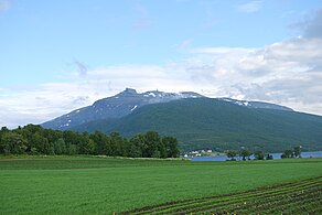 View from Gibostad towards Kistefjellet on the mainland
 -
 Seashore on the Senja island in Norway
 -
 Ersfjorden and near mountains
 -
 View from a ridge between Segla and Hesten, Senja, Norway
 -
-
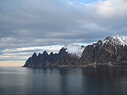
 Okshornan peaks viewed from Tungeneset


.jpg)
.jpg)


References
- ^ a b "Høgaste fjelltopp i kvar kommune" (in Norwegian). Kartverket. 16 January 2024.
- ^ "Navn på steder og personer: Innbyggjarnamn" (in Norwegian). Språkrådet.
- ^ "Forskrift om målvedtak i kommunar og fylkeskommunar" (in Norwegian). Lovdata.no.
- ^ Bolstad, Erik; Thorsnæs, Geir, eds. (26 January 2023). "Kommunenummer". Store norske leksikon (in Norwegian). Kunnskapsforlaget.
- ^ a b Thorsnæs, Geir, ed. (9 May 2018). "Senja". Store norske leksikon (in Norwegian). Kunnskapsforlaget. Retrieved 25 August 2018.
- ^ Statistisk sentralbyrå. "Table: 06913: Population 1 January and population changes during the calendar year (M)" (in Norwegian).
- ^ Statistisk sentralbyrå. "09280: Area of land and fresh water (km²) (M)" (in Norwegian).
- ^ "Senja kommune 2020" (in Norwegian). Retrieved 9 September 2017.
- ^ Vermes, Thomas (29 March 2017). "Stortingsflertallet gjør fire Senja-kommuner til én". ABC Nyheter (in Norwegian). Retrieved 9 September 2017.
- ^ "Fylkesinndelingen fra 2024" (in Norwegian). Regjeringen.no. 5 July 2022.
- ^ "Bidrag till Fennoskandiens språkliga förhistoria i tid och rum" (PDF) (in Swedish). Helsingfors Universitet. Retrieved 27 December 2015.
- ^ "Civic heraldry of Norway - Norske Kommunevåpen". Heraldry of the World. Retrieved 29 January 2023.
- ^ "Senja kommune, våpen". Digitalarkivet (in Norwegian). Arkivverket. Retrieved 29 January 2023.
- ^ Henriksen, Steinulf (25 May 2018). "Det viktigste Senja-våpen". Folkebladet (in Norwegian). Retrieved 25 August 2018.
- ^ Hansen, Tore; Vabo, Signy Irene, eds. (20 September 2022). "kommunestyre". Store norske leksikon (in Norwegian). Kunnskapsforlaget. Retrieved 14 October 2022.
- ^ "Kommunestyrevalg 2023 - Troms Romsa". Valgdirektoratet. Retrieved 6 January 2024.
- ^ "Tall for Norge: Kommunestyrevalg 2019 - Troms og Finnmark". Valg Direktoratet. Retrieved 23 October 2019.
- ^ Ellingsen, Rebekka; Klausen, Dag Henrik (9 October 2023). "Tidligere fiskeriminister blir ordfører i Senja". NRK Troms og Finnmark (in Norwegian). Retrieved 6 January 2024.
- ^ "eKlima Web Portal". Norwegian Meteorological Institute. Archived from the original on 14 June 2004.
- ^ "Ånderdalen National Park" (in Norwegian). Directorate for nature management. Retrieved 4 April 2010.
| |||||||
 | Towns and cities | ||||||
| Municipalities |
| ||||||
| |||||||