
Route F88 (Iceland)
(Redirected from Route 88 (Iceland))
65°21′11″N 16°03′54″W / 65.353°N 16.065°W
 | |
|---|---|
| Öskjuleið | |
| Route information | |
| Length | 80 km[1] (50 mi) |
| Major junctions | |
| Northern end | |
| Southern end | Route 910 |
| Location | |
| Country | Iceland |
| Highway system | |
Öskjuleið (Icelandic pronunciation: [ˈœscʏˌleiːθ]), or Route 88, is a road in north-east Iceland. The road heads south from Route 1, a ring road, close to the volcanic crater Hrossaborg [ˈr̥ɔssaˌpɔrk], to Route 910, not far from Askja.[1]
The road is the primary route to the tourist hotspots of Herðubreið and Hrossaborg.
-
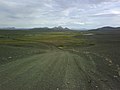
 Straight of F88
 -
 F88 close to Herðubreið
 -
 Route F88
 -
 Ford crossing on F88
 -
 Hrossaborg
 -
 Hrossaborg crater
 -
 Intersection between F88 and Hringvegur


References
- ^ Öskjuleið (Map). Cartography by OpenStreetMap contributors. OpenStreetMap. Retrieved January 9, 2012.
External links
![]() Media related to Road F88 (Iceland) at Wikimedia Commons
Media related to Road F88 (Iceland) at Wikimedia Commons
Routes through the interior highlands of Iceland | ||
|---|---|---|
|  | |
This Iceland location article is a stub. You can help Wikipedia by expanding it. |
This article about transport in Iceland is a stub. You can help Wikipedia by expanding it. |