
Makgadikgadi Pan
This article needs additional citations for verification. (September 2016) |
| Makgadikgadi Pan | |
|---|---|
 The Makgadikgadi pans are clearly visible to the right of the dark-green broom-shaped Okavango Delta in this satellite image of Botswana | |
 The main water source is the Nata River, called Amanzanyama in Zimbabwe, where it rises at Sandown about 37 mi (59.5 km) from Bulawayo. A smaller amount of water is supplied by the Boteti River from the Okavango delta. | |
| Geography | |
| Location | Okavango Delta |
| Country | Botswana |
| Coordinates | 20°48′S 25°20′E / 20.800°S 25.333°E |
The Makgadikgadi Pan /məˈkædiˈkædi/ (Tswana pronunciation [makχʰadiˈkχʰaːdi][needs tone]), a salt pan situated in the middle of the dry savanna of north-eastern Botswana, is one of the largest salt flats in the world. The pan is all that remains of the formerly enormous Lake Makgadikgadi, which once covered an area larger than Switzerland, but dried up tens of thousands of years ago. Recent studies of human mitochondrial DNA suggest that modern Homo sapiens first began to evolve in this region some 200,000 years ago, when it was a vast, exceptionally fertile area of lakes, rivers, marshes, woodlands and grasslands especially favorable for habitation by evolving hominins and other mammals.[1]
Location and description
Lying southeast of the Okavango Delta and surrounded by the Kalahari Desert, Makgadikgadi is technically not a single pan, but many pans with sandy desert in between, the largest being the Sua (Sowa), Ntwetwe and Nxai Pans. The largest individual pan is about 1,900 sq mi (4,921.0 km2). In comparison, Salar de Uyuni in Bolivia is a single salt flat of 4,100 sq mi (10,619.0 km2), rarely has much water, and is generally claimed to be the world's largest salt pan. A dry, salty, clay crust most of the year, the pans are seasonally covered with water and grass, and are then a refuge for birds and animals in this very arid part of the world. The climate is hot and dry, but with regular annual rains.
The main water source is the 330 kilometers (210 mi) long Nata River, called Amanzanyama in Zimbabwe, where it rises at Sandown about 37 mi (59.5 km) from Bulawayo. A smaller amount of water is supplied by the Boteti River from the Okavango Delta.[2]
These salt pans cover 6,200 sq mi (16,057.9 km2) in the Kalahari Basin and form the bed of the ancient Lake Makgadikgadi, which evaporated many millennia ago. Archaeological recovery in the Makgadikgadi Pan has revealed the presence of prehistoric man through abundant finds of stone tools; some of these tools have been dated sufficiently early to establish their origin as earlier than the era of Homo sapiens.[3] Pastoralists herded grazing livestock here when water was more plentiful earlier in the Holocene.[4]
The lowest place in the basin is Sua Pan with an elevation of 2,920 feet.[5]

Geology

As the ancestral Lake Makgadikgadi shrank, it left relic shorelines, which are most evident in the southwestern part of the basin.[5] As the lake shrank numerous smaller lakes formed with progressively smaller shorelines. The relic shorelines at elevations of 3100 feet and 3018 feet can be seen mostly easily on Gidikwe Ridge, west of the Boteti River.[5]
The geologic processes behind the formation of the basin are not well understood. It is conjectured that there was a gentle down-warping of the crust, with accompanying mild tectonics and associated faulting; however, no significant plate boundary faults have been identified.[5][6] The main axis of the developing graben runs northeast–southwest.[7]
Kubu Island and Kukome Island are igneous rock "islands" in the salt flat of Sua pan.[8] Kubu Island lies in the southwestern quadrant of Sua Pan, contains a number of baobab trees, and is protected as a national monument.[9]
Flora
,_parque_nacional_Makgadikgadi_Pans,_Botsuana,_2018-07-30,_DD_03-08_PAN.jpg)
The pans themselves are salty desert whose only plant life is a thin layer of blue-green algae. However the fringes of the pan are salt marshes and further out these are circled by grassland and then shrubby savanna. The prominent baobab trees found in the area function as local landmarks. One of them, named after James Chapman, served as an unofficial post office for 19th-century explorers.[10]
Fauna

Very little wildlife can exist here during the harsh dry season of strong hot winds and only salt water, but following a rain the pan becomes an important habitat for migrating animals including wildebeest and one of Africa's biggest zebra populations, and the large predators that prey on them. The wet season also brings migratory birds such as ducks, geese and great white pelicans. The pan is home of one of only two breeding populations of greater flamingos in southern Africa, and only on the Soa pan, which is part of the Makgadikgadi pans. The other breeding population is at Etosha, in the Northern part of Namibia. The only birds here in the dry season are ostriches, chestnut-banded plover (Charadrius pallidus) and Kittlitz's plover (Charadrius pecuarius). The grasslands on the fringes of the pan are home to reptiles such as tortoises, rock monitor (Varanus albigularis), snakes and lizards including the endemic Makgadikgadi spiny agama (Agama hispida makgadikgadiensis). The region's salt water is home to the cladoceran crustacean Moina belli.
Threats and preservation
The salt pans are very inhospitable and human intervention has been minimal so they remain fairly undisturbed, although land surrounding the pans is used for grazing and some areas have been fenced off, preventing the migration of wildlife. Modern commercial operations to extract salt and soda ash began on Sua Pan in 1991, and there are also plans to divert water from the Nata River for irrigation, which would cause severe damage to the salt pan ecosystem. Another threat is the use of quad bikes and off-road vehicles by tourists, which disturbs breeding colonies of flamingos. Illegal hunting in the national parks is a persistent problem.[citation needed]
There are some protected areas within the Makgadikgadi and Nxai Pan National Park. The Makgadikgadi Pans Game Reserve is the scene of large migrations of zebra and wildebeest from the Boteti River across to Ntwetwe Pan, while the Nata Sanctuary in Sua Pan is a place to see birdlife and antelopes. In Nxai Pan the baobabs painted by 19th century British artist Thomas Baines are still visible. The area can be accessed between the towns of Nata and Maun, or from the town of Gweta.
Gallery
-
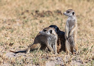 Colony of meerkats (Suricata suricatta)
 -
 Meerkats
 -
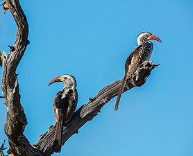 Southern red-billed hornbills (Tockus rufirostris)
 -
 Ostriches (Struthio camelus) in the salt pan
 -
 Cape ground squirrel (Xerus inauris)
,_parque_nacional_Makgadikgadi_Pans,_Botsuana,_2018-07-30,_DD_31.jpg)
,_parque_nacional_Makgadikgadi_Pans,_Botsuana,_2018-07-30,_DD_27.jpg)
,_parque_nacional_Makgadikgadi_Pans,_Botsuana,_2018-07-30,_DD_13.jpg)
,_salar_del_parque_nacional_Makgadikgadi_Pans,_Botsuana,_2018-07-30,_DD_51.jpg)
,_parque_nacional_Makgadikgadi_Pans,_Botsuana,_2018-07-30,_DD_15.jpg)
See also
References
- ^ Chan, E. K. F., 2019. Human origins in a southern African palaeo-wetland and first migrations. Nature doi: 10.1038/s41586-019-1714-1
- ^ The Lake That Completely Disappeared In Botswana | Our World, retrieved 15 August 2022
- ^ C. Michael Hogan (2008) Makgadikgadi, The Megalithic Portal, ed. A. Burnham [1]
- ^ Chris McIntyre (2008) Botswana: Okavango Delta, Chobe, Northern Kalahari, Bradt publishers, 502 pages ISBN 1-84162-166-8
- ^ a b c d Helgren, David M. (1984) "Historical Geomorphology and Geoarchaeology in the Southwestern Makgadikgadi Basin, Botswana" Annals of the Association of American Geographers 74(2): pp. 298–307, page 299
- ^ Cooke, H. J. (1980) "Landform evolution in the context of climatic change and neo-tectonism in the Middle Kalahari of north-central Botswana" Transactions, Institute of British Geographers 5: pp. 80–99, pages 83-84
- ^ Cooke, H. J. (1980) "Landform evolution in the context of climatic change and neo-tectonism in the Middle Kalahari of north-central Botswana" Transactions, Institute of British Geographers 5: pp. 80–99, page 85
- ^ McIntyre, Chris (2007) Botswana: Okavango Delta, Chobe, Northern Kalahari: the Bradt Safari Guide (2nd edition) Bradt, Chalfont, St. Peter, England, page 381, ISBN 978-1-84162-166-1
- ^ Hardy, Paula and Firestone, Matthew D. (2007) Botswana & Namibia Lonely Planet, Footscray, Victoria, Australia, page 100, ISBN 978-1-74104-760-8
- ^ Sissons, Mark (31 October 2010). "Makgadikgadi Pans - Kalahari safari stirs the soul". Hearst Communications Inc. Retrieved 31 October 2010.
External links
- Images from the Mkgadikgadi Pans
- "Zambezian halophytics". Terrestrial Ecoregions. World Wildlife Fund.