
Search results
There is a page named "File:York Street station front.jpg" on Wikipedia
 DescriptionYork Street station front.jpg English: View of the new frontage of Belfast York Street train station. Date 28 April 2024 Source Own work Author...(4,080 × 3,072 (4.31 MB)) - 20:52, 7 August 2024
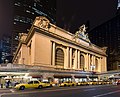 following license: English Grand Central terminal in New York, NY Vietnamese Nhà ga Grand Central ở New York, NY object has role: photographer author name string:...(4,726 × 3,805 (5.81 MB)) - 15:44, 23 March 2024
 portion of a 1909 map of Queens, New York, United States, showing Hollis station. The map was scanned by the New York Public Library with Digital Image ID...(1,150 × 630 (198 KB)) - 11:14, 15 February 2021
 New York, United States, showingen:Hollis (LIRR station). The map was scanned by the New York Public Library with Digital Image ID 1523090. The street heading...(732 × 572 (113 KB)) - 03:00, 16 January 2015
 an 1891 map of Queens, New York, United States, showing Flushing Main Street station. The map was scanned by the New York Public Library with Digital...(603 × 489 (119 KB)) - 11:10, 9 July 2021
 portion of an 1891 map of Queens, New York, United States, showing Morris Park station. The map was scanned by the New York Public Library with Digital Image...(368 × 312 (44 KB)) - 13:14, 7 December 2021
 portion of an 1891 map of Queens, New York, United States, showing Woodside station. The map was scanned by the New York Public Library with Digital Image...(550 × 448 (101 KB)) - 12:19, 3 December 2022
 portion of an 1891 map of Queens, New York, United States, showing Winfield station. The map was scanned by the New York Public Library with Digital Image...(744 × 440 (112 KB)) - 11:14, 15 February 2021
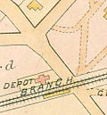 New York, United States, showing Newtown station. The map was scanned by the New York Public Library with Digital Image ID 1523091. The cross street is...(254 × 274 (36 KB)) - 15:21, 2 June 2015
 1891 map of Queens, New York, United States, showing en:Woodhaven Junction (LIRR station). The map was scanned by the New York Public Library with Digital...(430 × 475 (77 KB)) - 11:14, 15 February 2021
 1891 map of Queens, New York, United States, showing Corona station. The map, Woverton Atlas Plate 34, was scanned by the New York Public Library with Digital...(433 × 411 (70 KB)) - 11:14, 15 February 2021
 of an 1891 map of Queens, New York, United States, showing Clarenceville station. The map was scanned by the New York Public Library with Digital Image...(292 × 248 (36 KB)) - 11:14, 15 February 2021
 Bromley map of Queens, New York, United States, showing Bellaire station. The map, Plates 38 and 39, was scanned by the New York Public Library with Digital...(524 × 756 (103 KB)) - 21:33, 23 January 2015
 of an 1891 map of Queens, New York, United States, showing City Line (?) station. The map was scanned by the New York Public Library with Digital Image...(300 × 220 (26 KB)) - 11:14, 15 February 2021
 York, United States, showing Laurel Hill station. The map was scanned by the New York Public Library with Digital Image ID 1523091. The cross street is...(679 × 594 (114 KB)) - 02:08, 13 June 2024
 of a 1909 map of Queens, New York, United States, showing Rockaway Junction station. The map was scanned by the New York Public Library with Digital Image...(1,316 × 932 (217 KB)) - 11:14, 15 February 2021
 a 1909 map of Queens, New York, United States, showing Queens (Queens Village) station. The map was scanned by the New York Public Library with Digital...(736 × 658 (135 KB)) - 12:20, 3 December 2022
 an 1891 map of Queens, New York, United States, showing Queens (Queens Village) station. The map was scanned by the New York Public Library with Digital...(501 × 352 (67 KB)) - 12:19, 3 December 2022
 1891 map of Queens, New York, United States, showing Fresh Pond station and Bushwick Junction. The map was scanned by the New York Public Library with Digital...(502 × 408 (64 KB)) - 20:30, 28 September 2018
 l'intérieur d'une station. Photo personnelle. Looking south in the northern part of the mezzanine of en:59th Street–Columbus Circle (New York City Subway)...(2,592 × 1,952 (1.88 MB)) - 04:38, 20 September 2020


- The Knickerbocker Press Year of publication 1916 Place of publication New York & London Language english Description 1916 English-language translation of