
Search results
There is a page named "File:Tip-manila-map.jpg" on Wikipedia
 DescriptionTip-manila-map.jpg English: TIP Map - Manila Campus Source TIP Author TIP...(610 × 768 (66 KB)) - 02:30, 25 September 2020
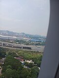 the following license: [Category:Aerial photographs of Metro Manila]] English We are entering the Philippines from the north, headed to Manila airport...(2,448 × 3,264 (1.21 MB)) - 08:36, 14 June 2024
 Batàn dialect as a member of the Philippine group of languages Publisher Manila : Bureau of Printing Description Microfilm no. 34 Microfilm From the Bartlett...(1,256 × 1,629 (8.76 MB)) - 07:43, 23 April 2022
 copyright holder of this work, hereby publish it under the following license: English We are entering the Philippines from the north, headed to Manila airport...(2,448 × 3,264 (1.27 MB)) - 04:35, 8 February 2024
 File:75967 South-China-Sea-1.pdf (category Maps of the South China Sea)id=dUg4DwAAQBAJ&pg=PT8 (map info) https://southseaconversations.files.wordpress.com/2015/06/luconia-shoals1.jpg (derived, copyrighted map South China Sea claims...(1,754 × 1,239 (3.71 MB)) - 18:18, 18 August 2024
 Attribution 2.0 truetrue 16 March 2020 English author name string: Ray in Manila operator: Flickr described at URL: https://www.flickr.com/photos/21186555@N07/25223762580...(2,723 × 1,600 (5.16 MB)) - 08:22, 12 July 2022
 2023 English Flickr user ID: 21186555@N07 author name string: . Ray in Manila URL: https://www.flickr.com/people/rayinmanila/ publication date: 25 February...(5,184 × 3,456 (6.17 MB)) - 10:13, 8 July 2024
 Attribution 2.0 truetrue 15 February 2023 English author name string: . Ray in Manila URL: https://www.flickr.com/people/21186555@N07 Flickr user ID: 21186555@N07...(2,882 × 2,604 (1.5 MB)) - 16:24, 5 August 2023
 This file has an extracted image: Report of the Puerto Rico Experiment Station (IA CAT31294391015) (page 3 crop).jpg....(952 × 1,510 (2.48 MB)) - 22:23, 11 February 2024
 Actress Kim Cương.jpg...(1,239 × 1,675 (12.69 MB)) - 05:55, 11 July 2023
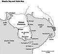 DescriptionManilaBaySubicBay1941.jpg English: Manila Bay and Subic Bay in 1941. US Navy map. Naval Station Sangley Point, Naval Base Cavite shipyard, Naval...(755 × 706 (105 KB)) - 06:41, 7 December 2022
 Tabaan Sur 16.2902, 120.5351 Tuba, Benguet located at at the south-western tip of both Benguet and the Cordillera Central (Luzon) surrounded served by the...(4,608 × 3,456 (6.4 MB)) - 08:09, 5 June 2023
 waiting sheds and covered court) Mount Kimmallugong 17°16'6"N 120°27'29"E egg-tipped mountain looks like a hat (kallugong) upon the boundaries of Gana and Sobredillo...(4,608 × 3,456 (6.98 MB)) - 04:25, 30 May 2023
 waiting sheds and covered court) Mount Kimmallugong 17°16'6"N 120°27'29"E egg-tipped mountain looks like a hat (kallugong) upon the boundaries of Gana and Sobredillo...(4,608 × 3,456 (6.85 MB)) - 04:25, 30 May 2023
 waiting sheds and covered court) Mount Kimmallugong 17°16'6"N 120°27'29"E egg-tipped mountain looks like a hat (kallugong) upon the boundaries of Gana and Sobredillo...(4,608 × 3,456 (6.51 MB)) - 04:25, 30 May 2023
 waiting sheds and covered court) Mount Kimmallugong 17°16'6"N 120°27'29"E egg-tipped mountain looks like a hat (kallugong) upon the boundaries of Gana and Sobredillo...(4,608 × 3,456 (7.02 MB)) - 04:25, 30 May 2023
 waiting sheds and covered court) Mount Kimmallugong 17°16'6"N 120°27'29"E egg-tipped mountain looks like a hat (kallugong) upon the boundaries of Gana and Sobredillo...(4,608 × 3,456 (6.57 MB)) - 04:25, 30 May 2023
 waiting sheds and covered court) Mount Kimmallugong 17°16'6"N 120°27'29"E egg-tipped mountain looks like a hat (kallugong) upon the boundaries of Gana and Sobredillo...(4,608 × 3,456 (6.05 MB)) - 04:25, 30 May 2023
 waiting sheds and covered court) Mount Kimmallugong 17°16'6"N 120°27'29"E egg-tipped mountain looks like a hat (kallugong) upon the boundaries of Gana and Sobredillo...(4,608 × 3,456 (6.35 MB)) - 04:25, 30 May 2023
 waiting sheds and covered court) Mount Kimmallugong 17°16'6"N 120°27'29"E egg-tipped mountain looks like a hat (kallugong) upon the boundaries of Gana and Sobredillo...(4,608 × 3,456 (6.41 MB)) - 04:25, 30 May 2023


.jpg)
,_Tsavo_West_National_Park,_Kenya_(52684080510).jpg)


