
Search results
There is a page named "File:Roman Empire 125 political map.svg" on Wikipedia
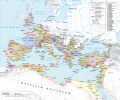 English A map of the Roman Empire in 125 AD, during the reign of the emperor Hadrian Latin American Spanish mapa del Imperio Romano en el 125 AD, durante...(2,186 × 1,817 (3.25 MB)) - 01:45, 29 June 2024
 the Roman Empire Spanish Localización de la provincia de Syria en el Imperio Romano Ukrainian Карта-локатор провінції Сирія в Римській імперії (125). Отримано...(2,186 × 1,817 (629 KB)) - 21:33, 29 April 2024
 Attribution-Share Alike 4.0 truetrue English The Alpes Cottiae province in the Roman Empire in 125 AD. Wikimedia username: Milenioscuro author name string: Milenioscuro...(2,186 × 1,817 (629 KB)) - 07:33, 27 October 2020
 Creative Commons Attribution-Share Alike 4.0 truetrue English Map of the Roman Empire with the province of Sicilia marked in red author name string:...(2,186 × 1,817 (629 KB)) - 18:17, 27 October 2020
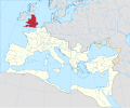 Attribution-Share Alike 4.0 truetrue English Locator map of the Britannia province in the Roman Empire URL: https://commons.wikimedia.org/wiki/user:Milenioscuro...(2,186 × 1,817 (629 KB)) - 00:58, 12 January 2024
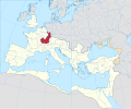 Attribution-Share Alike 4.0 truetrue English Locator map of the Germania Superior province in the Roman Empire author name string: Milenioscuro Wikimedia username:...(2,186 × 1,817 (629 KB)) - 20:03, 2 October 2021
 Attribution-Share Alike 4.0 truetrue English Locator map of the Alpes Poenninae et Graiae province in the Roman Empire Wikimedia username: Milenioscuro author name...(2,186 × 1,817 (629 KB)) - 05:16, 12 October 2021
 3.0 truetrue You may select the license of your choice. English Chinese 125年罗马帝国 Wikimedia username: Vikarna author name string: Vikarna URL: https://commons...(2,732 × 2,271 (2.02 MB)) - 01:46, 29 June 2024
 Attribution-Share Alike 4.0 truetrue English Raetia province in the Roman Empire author name string: Milenioscuro Wikimedia username: Milenioscuro URL:...(2,186 × 1,817 (629 KB)) - 04:53, 27 October 2023
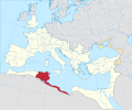 Attribution-Share Alike 4.0 truetrue English Africa Proconsularis province in the Roman Empire author name string: Milenioscuro Wikimedia username: Milenioscuro URL:...(2,186 × 1,817 (629 KB)) - 06:05, 8 December 2023
 angielskiej Image:Roman Empire 125 political map.svg, made by User:Andrein English: Political map of Roman Empire in 125 CE Date 11 October 2013, 21:31:40...(2,186 × 1,817 (3.27 MB)) - 01:46, 29 June 2024
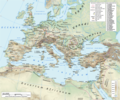 English The Roman empire under Hadrian (ruled 117–138) showing the location of roads, cities, provincial boundaries, naval bases, the Roman legions deployed...(2,186 × 1,817 (4.43 MB)) - 12:38, 18 June 2024
 DescriptionRoman Empire 125 political map-de.svg Deutsch: Karte des Römischen Reichs im Jahre 125. Projection Lambert azimuthal-equal area. Central latitude:...(2,186 × 1,817 (6.32 MB)) - 12:47, 30 January 2024
 3.0 truetrue You may select the license of your choice. English Chinese 125年罗马帝国 Wikimedia username: Vikarna author name string: Vikarna URL: https://commons...(2,049 × 1,703 (2.99 MB)) - 12:23, 7 December 2023
 0 Creative Commons Attribution-Share Alike 4.0 truetrue English Location map of Hispania Tarraconensis author name string: Milenioscuro Wikimedia username:...(2,186 × 1,817 (629 KB)) - 18:04, 20 November 2022
 125 political map.svg English: Locator map of the Cyprus province in the Roman Empire (125). Extracted from File:Roman Empire 125 political map.svg Date...(2,186 × 1,817 (629 KB)) - 19:23, 8 September 2020
 File:Roman Empire 125 political map.svg English: Locator map of the Narbonensis province in the Roman Empire (125). Extracted from File:Roman Empire 125 political...(2,186 × 1,817 (629 KB)) - 09:08, 17 October 2020
 125 political map.svg English: Locator map of the Belgica province in the Roman Empire (125). Extracted from File:Roman Empire 125 political map.svg Date...(2,186 × 1,817 (629 KB)) - 17:51, 27 October 2020
 125 political map.svg English: Locator map of the Thracia province in the Roman Empire (125). Extracted from File:Roman Empire 125 political map.svg Date...(2,186 × 1,817 (629 KB)) - 18:17, 27 October 2020
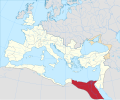 125 political map.svg English: Locator map of the Aegyptus province in the Roman Empire (125). Extracted from File:Roman Empire 125 political map.svg Date...(2,186 × 1,817 (629 KB)) - 18:17, 27 October 2020

.svg)
.svg)
.svg)
.svg)
.svg)
.svg)

.svg)
.svg)


.svg)
.svg)
.svg)
.svg)
.svg)
.svg)