
Search results
There is a page named "File:Raymore Drive in Raymore Park.JPG" on Wikipedia
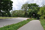 = Raymore Park, Toronto. Path on right leads to footbridge over Humber River. Parking area on left is built on the foundations of the former Raymore Drive...(4,288 × 2,848 (2.99 MB)) - 18:17, 11 September 2021
- media file may be available on the Wikimedia Commons as File:Raymore Drive in Raymore Park.JPG. While the license of this file may be compliant with the...(4,288 × 2,848 (2.99 MB)) - 18:50, 1 March 2011
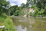 footbridge, looking toward east bank. Shot from Raymore Park, approximately 20 meters from neighbourhood destroyed by Hurricane Hazel in 1954. |Source English...(4,288 × 2,848 (3.03 MB)) - 19:04, 15 October 2020
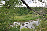 |Description = Humber River, Toronto, looking from East shore toward Raymore Park. Elevation approximately 45 meters above water level. |Source = I created...(4,288 × 2,848 (3.07 MB)) - 06:57, 19 October 2020
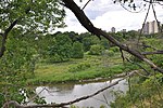 Humber River, Toronto, south of Lawrence Avenue, looking west toward Raymore Park. Taken from approx 45 meters above river level. |Source = I created this...(4,288 × 2,848 (3.05 MB)) - 18:17, 11 September 2021
 from the north. Left side of photo is east bank (Lions Park), right side is west bank (Raymore Park). |Source = I created this work entirely b English...(2,800 × 1,900 (3.04 MB)) - 18:17, 11 September 2021


