
File:Quebec langues.png
Size of this preview: 530 × 599 pixels. Other resolutions: 212 × 240 pixels | 424 × 480 pixels | 679 × 768 pixels | 905 × 1,024 pixels | 1,811 × 2,048 pixels | 3,311 × 3,745 pixels.
Original file (3,311 × 3,745 pixels, file size: 2.49 MB, MIME type: image/png)
| This is a file from the Wikimedia Commons. Information from its description page there is shown below. Commons is a freely licensed media file repository. You can help. |

|
This map image could be re-created using vector graphics as an SVG file. This has several advantages; see Commons:Media for cleanup for more information. If an SVG form of this image is available, please upload it and afterwards replace this template with
{{vector version available|new image name}}.
It is recommended to name the SVG file “Quebec langues.svg”—then the template Vector version available (or Vva) does not need the new image name parameter. |
Summary
| Description |
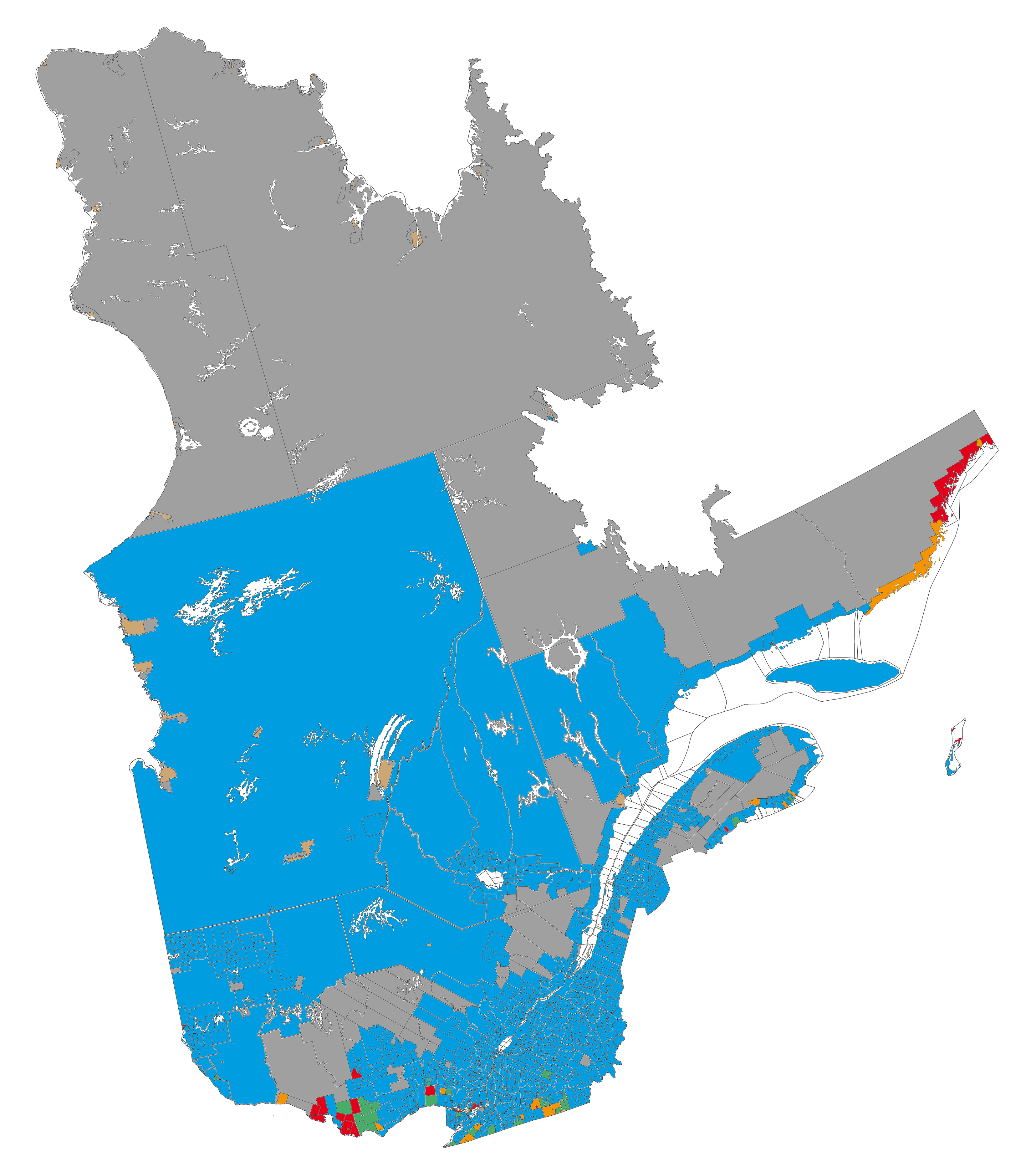
English (en): Linguistic map of the province of Quebec (source: Statistics Canada, 2006 census)
francophone majority, less than 33% anglophone francophone majority, more than 33% anglophone anglophone majority, less than 33% francophone anglophone majority, more than 33% francophone allophone majority (indigenous) data not available
français (fr): Carte linguistique de la province de Québec (source de données: Statistique Canada, recensement de 2006)
majorité francophone, moins de 33 % d'anglophones majorité francophone, plus de 33 % d'anglophones majorité anglophone, moins de 33 % de francophones majorité anglophone, plus de 33 % de francophones majorité allophone (autochtones) données non disponibles
|
| Date | |
| Source | Own work |
| Author | Piotron |
| Other versions | Derivative works of this file: Quebec langues TEST.png |
Licensing
I, the copyright holder of this work, hereby publish it under the following licenses:

|
Permission is granted to copy, distribute and/or modify this document under the terms of the GNU Free Documentation License, Version 1.2 or any later version published by the Free Software Foundation; with no Invariant Sections, no Front-Cover Texts, and no Back-Cover Texts. A copy of the license is included in the section entitled GNU Free Documentation License. |
This file is licensed under the Creative Commons Attribution 3.0 Unported license.
- You are free:
- to share – to copy, distribute and transmit the work
- to remix – to adapt the work
- Under the following conditions:
- attribution – You must give appropriate credit, provide a link to the license, and indicate if changes were made. You may do so in any reasonable manner, but not in any way that suggests the licensor endorses you or your use.
You may select the license of your choice.
File history
Click on a date/time to view the file as it appeared at that time.
| Date/Time | Thumbnail | Dimensions | User | Comment | |
|---|---|---|---|---|---|
| current | 18:21, 30 September 2015 | | 3,311 × 3,745 (2.49 MB) | Zorion | some popolation in Passes-Dangereuses, Rivière-aux-Outardes, Lac-Despinassy, Laniel, Les Lacs-du-Témiscamingue, Réservoir-Dozois, Lac-Matawin...etc |
| 21:20, 29 September 2015 |  | 3,311 × 3,745 (2.49 MB) | Zorion | Côte-Nord-du-Golfe-du-Saint-Laurent 33.51% French speaking | |
| 22:17, 12 February 2011 |  | 3,311 × 3,745 (2.71 MB) | Piotron | Proper version: 3311 x 3745 | |
| 22:15, 12 February 2011 |  | 1,000 × 1,131 (428 KB) | Piotron | Version with pixels (3311 x 3745) | |
| 20:08, 12 February 2011 |  | 5,000 × 5,656 (4.26 MB) | Piotron | {{Information |Description ={{fr|1=Carte linguistique de la province du Québec. * bleu - majorité francophone, moins de 33% d'anglophones * vert - majorité francophone, plus de 33% d'anglophones * rouge - majorité anglophone, moins de 33% de franco |
File usage
The following pages on the English Wikipedia use this file (pages on other projects are not listed):
Global file usage
The following other wikis use this file:
- Usage on ar.wikipedia.org
- Usage on de.wikipedia.org
- Usage on fa.wikipedia.org
- Usage on fr.wikipedia.org
- Usage on he.wikipedia.org
- Usage on ja.wikipedia.org
- Usage on pl.wikipedia.org
- Usage on pt.wikipedia.org
- Usage on ru.wikipedia.org
- Usage on sr.wikipedia.org
- Usage on zh-classical.wikipedia.org