
Search results
The page "File:Ph bukidnon malaybalay" does not exist. You can ask for it to be uploaded, but consider checking the search results below to see whether the topic is already covered.
 DescriptionPh bukidnon malaybalay topographicmap.png Topographic map of Malaybalay City, Bukidnon Date 1 February 2008 Source City Government of Malaybalay City...(2,148 × 1,959 (2.8 MB)) - 13:30, 13 June 2021
 DescriptionPh locator bukidnon malaybalay.png English: Map of the Bukidnon showing the location of Malaybay Date 2005 Source English Wikipedia Author...(300 × 300 (13 KB)) - 13:30, 13 June 2021
 DescriptionPh bukidnon malaybalay city map.png Political map of Malaybalay City Date 11 January 2008 Source Own work Author Kleomarlo...(2,238 × 1,845 (525 KB)) - 13:30, 13 June 2021
 DescriptionPh bukidnon malaybalay&cabanglasan soil map.PNG Soil map of Malaybalay City & Cabanglasan, Bukidnon Date 1 February 2008 Source City Government...(3,006 × 2,257 (702 KB)) - 13:30, 13 June 2021
 DescriptionPh bukidnon malaybalay city historical pop growth1918-2007.PNG English: Historical growth of population of Malaybalay City from 1918-2007 Date...(911 × 623 (20 KB)) - 13:30, 13 June 2021
 File:Capistrano Mountain.jpg (category Malaybalay)English This is Mt. Capistrano as seen from Barangay Managok, Malaybalay City, 8700 Bukidnon, Philippines. Wikimedia username: ANNALIEOSO URL: https://commons...(3,120 × 4,160 (4.76 MB)) - 13:12, 1 February 2024
 File:The Philippine journal of science (IA act3868.0025.001.umich.edu).pdf (matches file content)Mailag, Bukidnon Subprovince, has a terrace cut practically around it at an elevation of about 400 meters. The hills west of Malaybalay, Bukidnon, exhibit...(1,377 × 1,564 (28.17 MB)) - 05:42, 14 December 2020
 DescriptionForest Camp, Dahilayan, Malaybalay Bukidnon.jpg English: A view of the Forest Camp in Dahilayan Bukidnon as the morning fog subsides Date 12...(3,456 × 2,304 (1.05 MB)) - 13:30, 13 June 2021
 File:Datu & Bae.jpg (category Uploaded via Campaign:wlfa-ph)Attribution-Share Alike 4.0 truetrue English The indigenous costume of the people of Bukidnon author name string: Theglennpalacio Wikimedia username: Theglennpalacio...(4,000 × 6,000 (22.09 MB)) - 17:39, 10 December 2021
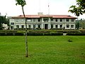 DescriptionPh bukidnon provincial capitol.JPG Provincial Capitol of Bukidnon in Malaybalay City Date 23 January 2008 Source Own work Author Kleomarlo...(2,592 × 1,944 (1.26 MB)) - 09:37, 23 December 2023
 {{Information |Description=Age Distribution of Bukidnon, 2000 |Source=self-made |Date=January 15, 2007 |Location=Malaybalay City |Author=[[User:Kleomarlo|Kleomarlo]]...(676 × 448 (34 KB)) - 08:40, 6 September 2020
 {{Information |Description=Bukidnon's population by Congressional District |Source=self-made |Date=January 15, 2007 |Location=Malaybalay City |Author=Data sourced...(600 × 417 (10 KB)) - 20:43, 9 January 2024
 {{Information |Description=Bukidnon's Population by Ethnic Origin, 2000 |Source=self-made |Date=January 15, 2008 |Location=Malaybalay City...(695 × 342 (11 KB)) - 20:43, 9 January 2024
 DescriptionAglayanseal.png Seal of Barangay Aglayan, Malaybalay, Bukidnon Date July 2019 Source http://malaybalaycity.gov.ph/malaybalay-dev/aglayan/ Author Barangay Government...(1,024 × 1,024 (452 KB)) - 18:12, 2 November 2023


