
Search results
There is a page named "File:Perth LGA WA.png" on Wikipedia
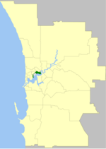 DescriptionPerth LGA WA.png English: Location of the Local Government Area w:City of Perth in Perth, Western Australia Date 5 December 2009 Source Own...(418 × 588 (32 KB)) - 00:56, 30 January 2024
 DescriptionSouth Perth LGA WA.png English: Location of the Local Government Area w:City of South Perth in Perth, Western Australia Date 5 December 2009...(418 × 588 (32 KB)) - 01:02, 30 January 2024
 Location: 833km northeast of Perth Shire: Leonora Population: 1196 Postcode: 6438 English...(383 × 601 (38 KB)) - 19:36, 16 September 2020
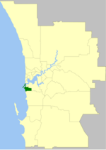 DescriptionFremantle LGA WA.png English: Location of the Local Government Area w:City of Fremantle in Perth, Western Australia Date 5 December 2009 Source...(418 × 588 (32 KB)) - 00:54, 30 January 2024
 DescriptionCanning LGA WA.png English: Location of the Local Government Area w:City of Canning in Perth, Western Australia Date 5 December 2009 Source...(418 × 588 (32 KB)) - 06:12, 31 January 2024
 DescriptionWanneroo LGA WA.png English: Location of the Local Government Area w:City of Wanneroo in Perth, Western Australia Date 5 December 2009 Source...(418 × 588 (32 KB)) - 01:05, 30 January 2024
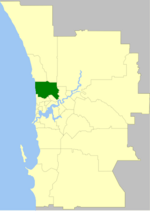 DescriptionStirling LGA WA.png English: Location of the Local Government Area w:City of Stirling in Perth, Western Australia Date 5 December 2009 Source...(418 × 588 (32 KB)) - 01:02, 30 January 2024
 DescriptionCockburn LGA WA.png English: Location of the Local Government Area w:City of Cockburn in Perth, Western Australia Date 5 December 2009 Source...(418 × 588 (32 KB)) - 21:44, 23 March 2024
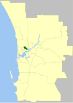 DescriptionVincent LGA WA.png English: Location of the Local Government Area w:Town of Vincent in Perth, Western Australia Date 5 December 2009 Source...(418 × 588 (32 KB)) - 01:05, 30 January 2024
 DescriptionMelville LGA WA.png English: Location of the Local Government Area w:City of Melville in Perth, Western Australia Date 5 December 2009 Source...(418 × 588 (32 KB)) - 00:55, 30 January 2024
 DescriptionJoondalup LGA WA.png English: Location of the Local Government Area w:City of Joondalup in Perth, Western Australia Date 5 December 2009 Source...(418 × 588 (32 KB)) - 00:54, 30 January 2024
 DescriptionClaremont LGA WA.png English: Location of the Local Government Area w:Town of Claremont in Perth, Western Australia Date 5 December 2009 Source...(418 × 588 (32 KB)) - 22:52, 18 March 2024
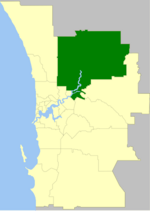 DescriptionSwan LGA WA.png English: Location of the Local Government Area w:City of Swan in Perth, Western Australia Date 5 December 2009 Source Own work...(418 × 588 (32 KB)) - 01:02, 30 January 2024
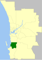 DescriptionKwinana LGA WA.png English: Location of the Local Government Area w:Town of Kwinana in Perth, Western Australia Date 5 December 2009 Source...(418 × 588 (32 KB)) - 00:55, 30 January 2024
 DescriptionRockingham LGA WA.png English: Location of the Local Government Area w:City of Rockingham in Perth, Western Australia Date 5 December 2009...(418 × 588 (32 KB)) - 00:57, 30 January 2024
 DescriptionSubiaco LGA WA.png English: Location of the Local Government Area w:City of Subiaco in Perth, Western Australia Date 5 December 2009 Source...(418 × 588 (32 KB)) - 01:02, 30 January 2024
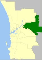 DescriptionMundaring LGA WA.png English: Location of the Local Government Area w:Shire of Mundaring in Perth, Western Australia Date 5 December 2009 Source...(418 × 588 (32 KB)) - 00:56, 30 January 2024
 DescriptionBelmont LGA WA.png English: Location of the Local Government Area w:City of Belmont in Perth, Western Australia Date 5 December 2009 Source...(418 × 588 (32 KB)) - 00:48, 30 January 2024
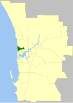 DescriptionCambridge LGA WA.png English: Location of the Local Government Area w:Town of Cambridge in Perth, Western Australia Date 5 December 2009 Source...(418 × 588 (32 KB)) - 00:48, 30 January 2024
 DescriptionNedlands LGA WA.png English: Location of the Local Government Area w:City of Nedlands in Perth, Western Australia Date 5 December 2009 Source...(418 × 588 (32 KB)) - 00:56, 30 January 2024


