
File:Pacific Telegraph Route - map, 1862.jpg
Size of this preview: 800 × 139 pixels. Other resolutions: 320 × 55 pixels | 640 × 111 pixels | 4,325 × 750 pixels.
Original file (4,325 × 750 pixels, file size: 2.58 MB, MIME type: image/jpeg)
| This is a file from the Wikimedia Commons. Information from its description page there is shown below. Commons is a freely licensed media file repository. You can help. |
Summary
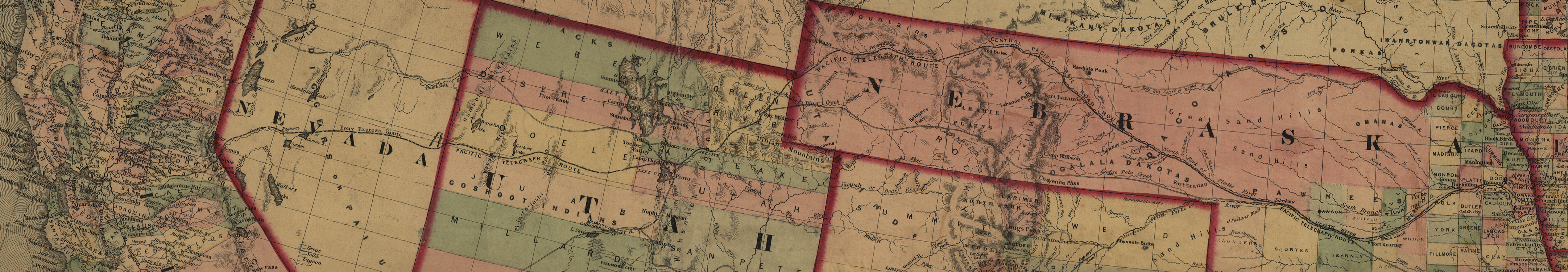
| Description | Map depicting the Pacific Telegraph Route, which was the western half of the First Transcontinental Telegraph line in the United States. The line was completed in 1861. |
| Date | |
| Source | "The New Naval and Military Map of the United States", by J. Calvin Smith, J. M. Atwood, map engraver, Philadelphia, Pa. 1862. 'Entered according to Act of Congress in the year 1862 by Robert P. Smith.' Library of Congress Geography and Map Division, Washington, D.C., via the website www.telegraph-history.org. |
| Author | J. Calvin Smith, J. M. Atwood, map engraver. |
| Permission (Reusing this file) |
Public domain - author died more than 70 years ago. |
Licensing
|
This work is in the public domain in its country of origin and other countries and areas where the copyright term is the author's life plus 70 years or fewer. | |
| This file has been identified as being free of known restrictions under copyright law, including all related and neighboring rights. | |
File history
Click on a date/time to view the file as it appeared at that time.
| Date/Time | Thumbnail | Dimensions | User | Comment | |
|---|---|---|---|---|---|
| current | 22:19, 24 February 2007 | 4,325 × 750 (2.58 MB) | Daderot | {{Information |Description=Map depicting the Pacific Telegraph Route, which was the western half of the First Transcontinental Telegraph line in the United States. The line was completed in 1861. |Source="The New Naval and Military Map of the United State |
File usage
The following pages on the English Wikipedia use this file (pages on other projects are not listed):
Global file usage
The following other wikis use this file:
- Usage on hu.wikipedia.org
- Usage on it.wikipedia.org