
Search results
There is a page named "File:Mn-map.png" on Wikipedia
 DescriptionMn-map.png Deutsch: Karte Monaco, von Benutzer:Head übersetzt CIA World Factbook Source CIA World Fact Book Author CIA...(330 × 355 (8 KB)) - 10:25, 17 May 2023
 Adapted from Wikipedia's MN county maps by Catbar. w:en:Image:MNMap-doton-Austin.png by Catbar, 11/5/2005 0:26 (UTC) English...(262 × 300 (10 KB)) - 00:24, 15 September 2020
 Adapted from Wikipedia's MN county maps by Catbar. w:en:Image:MNMap-doton-Two_Harbors.png by Catbar, 10/26/2005 22:44 (UTC) English...(262 × 300 (10 KB)) - 02:24, 4 October 2020
 Adapted from Wikipedia's MN county maps by Catbar. w:en:Image:MNMap-doton-Duluth.png by Catbar, 11/12/2005 12:06 (UTC) English determination method: SHA-1...(262 × 300 (10 KB)) - 05:44, 20 July 2024
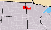 bytes) Taken from this Wikipedia map: [http://upload.wikimedia.org/wikipedia/commons/f/f6/Map_of_USA_with_county_outlines.png] and the information is from...(372 × 217 (10 KB)) - 23:22, 21 February 2024
 Creative Commons Attribution-Share Alike 4.0 truetrue English Duluth MN-WI Metropolitan Map author name string: Ironrangeedits Wikimedia username: Ironrangeedits...(300 × 300 (58 KB)) - 07:41, 18 December 2022
 truetrue This image is a derivative work of the following images: File:MN_Area_Codes.png licensed with Cc-by-sa-3.0,2.5,2.0,1.0, GFDL 2007-11-10T04:43:55Z...(200 × 222 (11 KB)) - 01:26, 13 September 2023
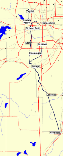 Route map of the Minneapolis, Northfield and Southern Railway. The MN&S line is in dark blue; other railroads are dotted lines. Base map from the National...(337 × 822 (136 KB)) - 03:43, 30 December 2011
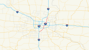 DescriptionI-35E (MN) map.png Map of w:Interstate 35E (Minnesota) Source Own work Author Algorerhythms...(1,750 × 978 (74 KB)) - 07:19, 1 September 2020
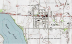 DescriptionCeylon, MN topo map.png English: Scan of USGS topographical map Date 12 June 2013 Source http://mapper.acme.com/?ll=43.5335672,-94.6316462&z=15...(763 × 463 (626 KB)) - 22:28, 19 February 2024
 DescriptionMN House 2018 vote share.png A series of state legislative election maps, created from open data during the summer of 2020. Their common visual...(2,983 × 2,040 (2.97 MB)) - 15:25, 28 May 2024
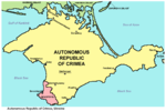 MapCrimea.Added..jpg http://weecheng.com/europe/bbs/crimea/crimea-map.jpg http://www.travel2crimea.com/image/common/map_of_crimea.png archive...(1,031 × 684 (65 KB)) - 22:35, 24 April 2024
 Mankato in Minnesota. Adapted from Wikipedia's MN county maps by Catbar. English...(262 × 300 (10 KB)) - 18:27, 9 October 2020
 user names refer to en.wikipedia) 2005-06-17 00:44 Catbar 262×300×8 (10246 bytes) {{GFDL}}<br>Adapted from Wikipedia's MN county maps by Catbar. English...(262 × 300 (10 KB)) - 05:54, 26 April 2022
 This map was created with Quantum GIS with data from the [http://www.lmic.state.mn.us/chouse/metadata/mntel03.html Minnesota Land Management Information...(763 × 830 (24 KB)) - 05:38, 24 April 2024
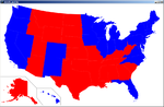 McCain statesColoring(McCain, color(255, 0, 0)); // Save the map as image saveFrame("map output.png"); } void statesColoring(String[] states, int c){ for (int...(956 × 625 (71 KB)) - 01:35, 12 February 2023
 user names refer to en.wikipedia) 2005-06-22 00:46 Catbar 262×300×8 (10259 bytes) {{GFDL}}<br>Adapted from Wikipedia's MN county maps by Catbar. English...(262 × 300 (10 KB)) - 05:46, 26 April 2022
 user names refer to en.wikipedia. 2005-06-18 00:07 Catbar 262×300×8 (10261 bytes) {{GFDL}}<br>Adapted from Wikipedia's MN county maps by Catbar. English...(262 × 300 (10 KB)) - 05:51, 26 April 2022
 user names refer to en.wikipedia. 2005-06-18 00:21 Catbar 262×300×8 (10265 bytes) {{GFDL}}<br>Adapted from Wikipedia's MN county maps by Catbar. English...(262 × 300 (10 KB)) - 05:45, 26 April 2022
 user names refer to en.wikipedia. 2005-04-02 00:06 Catbar 262×300×8 (10240 bytes) {{GFDL}}<br>Adapted from Wikipedia's MN county maps by Catbar. English...(262 × 300 (10 KB)) - 05:57, 26 April 2022


_map.png)


