
File:Memorial Day 2020 - San Francisco Under Quarantine (49935629483).jpg

Size of this preview: 800 × 533 pixels. Other resolutions: 320 × 213 pixels | 640 × 427 pixels | 1,024 × 683 pixels | 1,280 × 853 pixels | 2,560 × 1,707 pixels | 5,295 × 3,530 pixels.
Original file (5,295 × 3,530 pixels, file size: 29.08 MB, MIME type: image/jpeg)
| This is a file from the Wikimedia Commons. Information from its description page there is shown below. Commons is a freely licensed media file repository. You can help. |
Summary
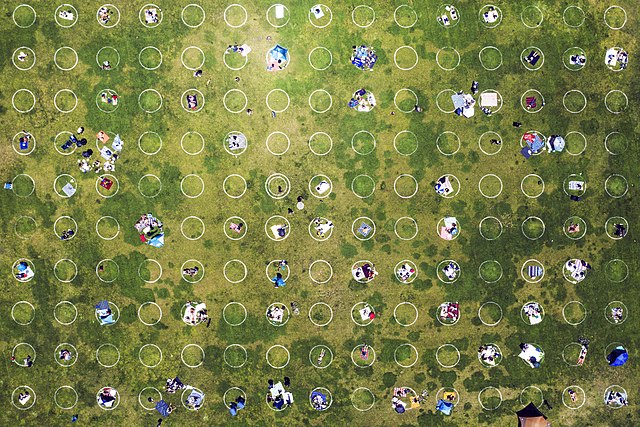
| Description | A series of white circles 10 feet (3.0 m) in diameter, spaced 8 feet (2.4 m) apart, are painted on the grass at Mission Dolores Park in San Francisco to encourage social distancing during the COVID-19 pandemic. Many of the circles were in use on Memorial Day. | ||
| Date | |||
| Source | Memorial Day 2020 - San Francisco Under Quarantine | ||
| Author | Christopher Michel from San Francisco, USA | ||
| Other versions |
|
_-_edited.jpg)
.jpg)
| Camera location | | View this and other nearby images on: OpenStreetMap |
|---|
.jpg¶ms=037.760469_N_-122.427006_E_globe:Earth_type:camera_source:Flickr_&language=en)
|
.jpg)
Licensing
This file is licensed under the Creative Commons Attribution 2.0 Generic license.
- You are free:
- to share – to copy, distribute and transmit the work
- to remix – to adapt the work
- Under the following conditions:
- attribution – You must give appropriate credit, provide a link to the license, and indicate if changes were made. You may do so in any reasonable manner, but not in any way that suggests the licensor endorses you or your use.
| This image was originally posted to Flickr by Christopher.Michel at https://flickr.com/photos/50979393@N00/49935629483. It was reviewed on 26 May 2020 by FlickreviewR 2 and was confirmed to be licensed under the terms of the cc-by-2.0. |
File history
Click on a date/time to view the file as it appeared at that time.
| Date/Time | Thumbnail | Dimensions | User | Comment | |
|---|---|---|---|---|---|
| current | 13:21, 26 May 2020 | | 5,295 × 3,530 (29.08 MB) | Tm | Transferred from Flickr via #flickr2commons |
File usage
The following pages on the English Wikipedia use this file (pages on other projects are not listed):
Global file usage
The following other wikis use this file:
- Usage on ar.wikipedia.org
- Usage on fr.wikipedia.org
- Usage on ha.wikipedia.org
- Usage on su.wikipedia.org
- Usage on vi.wikipedia.org
.jpg)