
Search results
There is a page named "File:Map of war in Yugoslavia, 1993.png" on Wikipedia
 Changed front lines around Bihać. See http://en.wikipedia.org/wiki/Image:Western_Bosnia_1994.png 2006-09-06 00:05 Ceha 1887×1242× (97506 bytes) English...(1,887 × 1,242 (195 KB)) - 00:56, 31 July 2023
 GFDL 2006-06-25T23:32:09Z SwPawel 1887x1192 (63283 Bytes) Map of former Yugoslavia during war. Author: Paweł Goleniowski (swPawel) Uploaded with derivativeFX...(1,285 × 892 (101 KB)) - 15:41, 24 November 2020
 Creative Commons Attribution-Share Alike 4.0 truetrue English Map of Yugoslavia around late 1993. author name string: Ljutikecap2021 Wikimedia username: Ljutikecap2021...(2,364 × 2,048 (306 KB)) - 22:32, 18 February 2024
 Attribution-Share Alike 4.0 truetrue English This is a map showing the countries involved in the yugoslav wars in 1993 with flags author name string: Wilhelm ii0...(1,080 × 878 (511 KB)) - 17:00, 26 October 2022
 00:31 SwPawel2 1887×1192× (63283 bytes) Map of former Yugoslavia during last wars. War political entitles in Croatia and Bosnia-Herzegovia are marked...(1,887 × 1,242 (196 KB)) - 14:34, 26 June 2023
 license, and indicate if changes were made. You may do so in any reasonable manner, but not in any way that suggests the licensor endorses you or your use...(1,000 × 666 (454 KB)) - 17:35, 14 October 2020
 license, and indicate if changes were made. You may do so in any reasonable manner, but not in any way that suggests the licensor endorses you or your use...(1,000 × 666 (395 KB)) - 17:35, 14 October 2020
 around Bihać. see [http://en.wikipedia.org/wiki/Image:Western_Bosnia_1994.png] 2006-09-06 00:08 Ceha 1887×1242× (97673 bytes) English Serbian mapa Jugoslavije...(1,887 × 1,242 (148 KB)) - 06:47, 14 July 2022
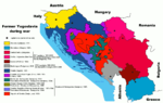 00:31 SwPawel2 1887×1192× (63283 bytes) Map of former Yugoslavia during last wars. War political entitles in Croatia and Bosnia-Herzegovia are marked...(1,887 × 1,192 (62 KB)) - 23:28, 8 December 2023
 File:Iugoslavia na guerra-GL.svg (category Maps of the Yugoslav wars)Modified by me from File:Former Yugoslavia wartime.png Based on bitmap by: swPawel SVG by: commons: Shazz, pl.wiki: Shazz Trannslation by: user:Sobreira...(1,832 × 1,142 (287 KB)) - 23:22, 8 December 2023
 org/licenses/by-sa/4.0CC BY-SA 4.0 Creative Commons Attribution-Share Alike 4.0 truetrue English The break up of Yugoslavia and a civil war in Afghanistan:(...(4,974 × 2,519 (805 KB)) - 05:25, 27 May 2024
 Ceha at English Wikipedia, the copyright holder of this work, hereby publishes it under the following licenses: This file is licensed under the Creative...(1,887 × 1,242 (192 KB)) - 08:56, 26 July 2024
 license, and indicate if changes were made. You may do so in any reasonable manner, but not in any way that suggests the licensor endorses you or your use...(1,000 × 666 (473 KB)) - 17:35, 14 October 2020
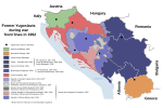 license, and indicate if changes were made. You may do so in any reasonable manner, but not in any way that suggests the licensor endorses you or your use...(1,000 × 666 (563 KB)) - 17:36, 14 October 2020
 DescriptionWestern Autonomous Republics of the Former Yugoslavia 1993.png Western Autonomous Republics of the Former Yugoslavia 1993 Date Created Sept 11, 2007 Source...(1,620 × 634 (244 KB)) - 20:25, 8 February 2023
 I, the copyright holder of this work, hereby publish it under the following license: This file is licensed under the Creative Commons Attribution-Share...(800 × 693 (141 KB)) - 11:34, 25 March 2024
 I, the copyright holder of this work, hereby publish it under the following license: This file is licensed under the Creative Commons Attribution-Share...(5,376 × 3,968 (813 KB)) - 07:50, 31 July 2022
 File:AtlBalk1942.jpg (category Maps of the Axis occupation of Yugoslavia)ISBN 2-7071-2505-9, "Europe centrale" : 1992, ISBN 2-7071-2032-4, "Orient" : 1993, ISBN 2-7071-2222-X, avec des détails pris dans le Történelmi atlasz de l'Académie...(318 × 327 (141 KB)) - 01:48, 4 August 2024
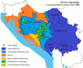 File:Ratna Srbija.gif (category Maps of the Yugoslav wars)information sheet). Date 2009 Source Former Yugoslavia wartime.png Author Former Yugoslavia wartime.png: SwPawel derivative work: Mladifilozof Permission...(1,353 × 1,111 (333 KB)) - 06:50, 5 October 2020


.png)


