
Search results
There is a page named "File:Map of Upper Silesia.png" on Wikipedia
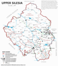 0 Creative Commons Attribution-Share Alike 4.0 truetrue English Map of Upper Silesia in English URL: https://commons.wikimedia.org/wiki/user:Gaj777 Wikimedia...(4,172 × 4,702 (3.14 MB)) - 07:17, 25 October 2022
 Province of Upper Silesia (red}, within the Kingdom of Prussia (blue). Other members of the German Confederation shown in black. Map data of the IEG-Maps project...(1,750 × 1,486 (140 KB)) - 17:58, 11 July 2024
 English Upper Silesia Frontier, 1921...(1,061 × 1,147 (463 KB)) - 17:40, 31 July 2023
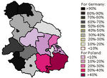 Creative Commons Attribution-Share Alike 4.0 truetrue English 1921 Upper Silesia Plebscite Map author name string: Asekh8463 Wikimedia username: Asekh8463 URL:...(325 × 239 (16 KB)) - 10:56, 12 August 2024
 Creative Commons Attribution-Share Alike 4.0 truetrue English 1921 Upper Silesia Plebscite Map author name string: Asekh8463 Wikimedia username: Asekh8463 URL:...(215 × 239 (3 KB)) - 10:56, 12 August 2024
 (1) Silesia (Clickable map) (2) Bohemia (Clickable map) (3) Moravia (Clickable map) (4) Netherlands (5)(e)(f) Banat (Clickable map) (6) Transylvania (Clickable...(1,673 × 1,277 (3.17 MB)) - 12:46, 15 October 2020
 (1) Silesia (Clickable map) (2) Bohemia (Clickable map) (3) Moravia (Clickable map) (4) Netherlands (5)(e)(f) Banat (Clickable map) (6) Transylvania (Clickable...(1,673 × 1,277 (3.17 MB)) - 13:29, 18 October 2020
 0 truetrue English German localized map of propositions for divion of Upper Silesia following the plebiscite of 1921. German Deutschsprachige Karte der...(1,852 × 3,080 (1.73 MB)) - 00:54, 8 August 2024
 0 Creative Commons Attribution-Share Alike 3.0 truetrue English Map of upper Silesia, author: Tymoteusz Trzewiczek Polish Mapa Górnego Śląska autor: Tymoteusz...(808 × 755 (130 KB)) - 12:50, 31 July 2024
 File:Granice 1921 slask adjustable.xcf (category Maps of the Upper Silesia plebiscite)Attribution 4.0 truetrue English Editable map of propositions for divion of Upper Silesia following the plebiscite of 1921. German Bearbeitbare Karte der Teilungspläne...(1,852 × 3,080 (3.85 MB)) - 16:51, 5 August 2024
 0 Creative Commons Attribution-Share Alike 4.0 truetrue English Map of Upper Silesia in Polish Polish Mapa Górnego Śląska w języku polskim URL: https://commons...(3,650 × 4,114 (2.61 MB)) - 07:17, 25 October 2022
 0 Creative Commons Attribution-Share Alike 4.0 truetrue English Map of Upper Silesia in Czech Czech Mapa Horního Slezska v českém jazyce URL: https://commons...(4,693 × 5,290 (3.13 MB)) - 15:29, 14 March 2022
 a derivative work of the following images: File:1801_Cary_Map_of_Upper_Saxony,_Germany_(_Berlin,_Dresden_)_-_Geographicus_-_UpperSaxony-cary-1799.jpg...(1,755 × 1,253 (6.29 MB)) - 18:52, 29 December 2015
 0 Creative Commons Attribution-Share Alike 4.0 truetrue English Map of Upper Silesia in Silesian Silesian Mapa Gōrnego Ślōnska we ślōnskij gŏdce URL:...(6,321 × 7,053 (4.69 MB)) - 20:35, 22 April 2023
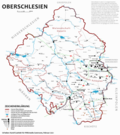 0 Creative Commons Attribution-Share Alike 4.0 truetrue English Map of Upper Silesia in German German Karte von Oberschlesien in deutscher Sprache Polish...(4,172 × 4,702 (3.14 MB)) - 10:14, 25 October 2022
 [[Category:Public transport maps of Poland] English...(10,357 × 9,249 (41.93 MB)) - 00:01, 30 June 2022
 I, the copyright holder of this work, hereby publish it under the following license: English URL: https://commons.wikimedia.org/wiki/user:Psi%C5%8Fczek...(3,290 × 3,664 (734 KB)) - 04:07, 10 November 2022
 I, the copyright holder of this work, hereby publish it under the following license: English URL: https://commons.wikimedia.org/wiki/user:Psi%C5%8Fczek...(3,290 × 3,664 (334 KB)) - 04:07, 10 November 2022
 https://creativecommons.org/licenses/by-sa/2.5CC BY-SA 2.5 Creative Commons Attribution-Share Alike 2.5 truetrue English Map of Upper Silesian Plebiscite of 1921...(5,000 × 3,239 (624 KB)) - 17:14, 1 May 2024
 I, the copyright holder of this work, hereby publish it under the following license: English...(3,290 × 3,664 (863 KB)) - 04:07, 10 November 2022


.png)


.png)


