
Search results
There is a page named "File:MapCirca1700 Bastimentos Portobelo Panama.png" on Wikipedia
 DescriptionMapCirca1700 Bastimentos Portobelo Panama.png "Plano de Pto. Velo". Map (upside down/orientation with south at top) of north-east coast of Panama from...(1,654 × 1,118 (2.46 MB)) - 15:09, 3 November 2020
 607 2480 2394 Isla Grande de Bastimentos ("Big Island", now called Isla Grande) 4 1207 423 464 2480 2394 Isla de Bastimentos Chica (Small Island) 879 68...(2,480 × 2,394 (4.76 MB)) - 18:42, 28 October 2022
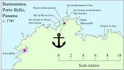 acquired Oct 1927 by the Map Division, Library of Congress, G4874.P6A1 17 P5 Vault (see File:MapCirca1700 Bastimentos Portobelo Panama.png . Showing the probable...(744 × 422 (544 KB)) - 12:16, 19 December 2021
 DescriptionBastimentos Portobelo Panama Map Circa1700 Detail.png Detail from Spanish map, c.1700 (orientation inverted, north at bottom) showing Bastimentos anchorage...(1,918 × 1,080 (2.33 MB)) - 09:45, 4 November 2023


