
Search results
There is a page named "File:Leeds UK locator map.svg" on Wikipedia
 DescriptionLeeds UK locator map.svg Map of West Yorkshire, UK with Leeds highlighted. Equirectangular map projection on WGS 84 datum, with N/S stretched...(1,425 × 1,039 (765 KB)) - 10:38, 8 July 2022
 seen in the Wikipedia article. Here's a mapping of the path IDs used in the SVG file to the names of the constituencies: English determination method: SHA-1...(690 × 982 (509 KB)) - 07:07, 10 April 2023
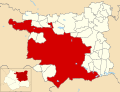 DescriptionLeeds unparished area UK locator map.svg Map of Leeds, West Yorkshire, UK with the unparished area of Leeds highlighted. Date 8 November 2015...(1,425 × 1,086 (602 KB)) - 21:40, 16 September 2020
 org/licenses/by-sa/3.0CC BY-SA 3.0 Creative Commons Attribution-Share Alike 3.0 truetrue English Boundary of Leeds East in Yorkshire and the Humber...(773 × 671 (508 KB)) - 13:31, 7 July 2024
 org/licenses/by-sa/3.0CC BY-SA 3.0 Creative Commons Attribution-Share Alike 3.0 truetrue English Boundary of Leeds North East in Yorkshire and the Humber...(773 × 671 (508 KB)) - 13:31, 7 July 2024
 org/licenses/by-sa/3.0CC BY-SA 3.0 Creative Commons Attribution-Share Alike 3.0 truetrue English Boundary of Leeds South in Yorkshire and the Humber...(773 × 671 (508 KB)) - 22:52, 10 June 2024
 org/licenses/by-sa/3.0CC BY-SA 3.0 Creative Commons Attribution-Share Alike 3.0 truetrue English Boundary of Leeds North West in Yorkshire and the Humber...(773 × 671 (508 KB)) - 22:51, 10 June 2024
 org/licenses/by-sa/3.0CC BY-SA 3.0 Creative Commons Attribution-Share Alike 3.0 truetrue English Boundary of Leeds Central and Headingley in Yorkshire and the Humber...(773 × 671 (508 KB)) - 13:31, 7 July 2024
 org/licenses/by-sa/3.0CC BY-SA 3.0 Creative Commons Attribution-Share Alike 3.0 truetrue English Boundary of Leeds West and Pudsey in Yorkshire and the Humber...(773 × 671 (508 KB)) - 13:31, 7 July 2024
 org/licenses/by-sa/3.0CC BY-SA 3.0 Creative Commons Attribution-Share Alike 3.0 truetrue English Boundary of Leeds South West and Morley in Yorkshire and the Humber...(773 × 671 (508 KB)) - 13:31, 7 July 2024
 DescriptionGarforth unparished area UK locator map.svg Map of Leeds, West Yorkshire, UK with the unparished area of Garforth highlighted. Date 8 November...(1,425 × 1,086 (602 KB)) - 12:25, 17 July 2022
 DescriptionLeedsEast2007Constituency.svg English: Map of the new UK Parliament constituency of Leeds East. Source Own work Author Wereon...(319 × 249 (278 KB)) - 00:21, 8 September 2020
 DescriptionLeedsCentral2007Constituency.svg English: Map of the new UK Parliament constituency of Leeds Central. Source Own work Author Wereon...(319 × 249 (278 KB)) - 00:21, 8 September 2020
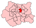 DescriptionLeedsWest2007Constituency.svg English: Map of the new UK Parliament constituency of Leeds West. Source Own work Author Wereon...(319 × 249 (278 KB)) - 00:22, 8 September 2020
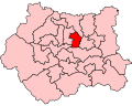 DescriptionLeedsWestConstituency.svg English: Map of the UK Parliament constituency of Leeds West, in West Yorkshire. Source Own work Author Wereon...(300 × 240 (83 KB)) - 00:22, 8 September 2020
 DescriptionLeedsEastConstituency.svg English: Map of the UK Parliament constituency of Leeds East, in West Yorkshire. Source Own work Author Wereon...(300 × 240 (83 KB)) - 00:21, 8 September 2020
 DescriptionLeedsCentralConstituency.svg English: Map of the UK Parliament constituency of Leeds Central, in West Yorkshire. Source Own work Author Wereon...(300 × 240 (83 KB)) - 00:21, 8 September 2020
 DescriptionLeedsNorthWest2007Constituency.svg English: Map of the new UK Parliament constituency of Leeds North West. Source Own work Author Wereon...(319 × 249 (278 KB)) - 00:22, 8 September 2020
 DescriptionLeedsNorthEast2007Constituency.svg English: Map of the new UK Parliament constituency of Leeds North East. Source Own work Author Wereon...(319 × 249 (278 KB)) - 00:21, 8 September 2020
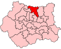 DescriptionLeedsNorthWestConstituency.svg English: Map of the UK Parliament constituency of Leeds North West, in West Yorkshire. Source Own work Author...(300 × 240 (83 KB)) - 00:22, 8 September 2020


