
Search results
There is a page named "File:Klamath Basin map.png" on Wikipedia
 DescriptionKlamath Basin map.png English: Map of the Klamath River basin in California and Oregon, United States. Klamath watershed shown in gray. The...(1,179 × 1,121 (1.92 MB)) - 11:39, 2 September 2023
 description page was here. All following user names refer to en.wikipedia. English Map of the Columbia River Basalt Group applies to jurisdiction: United States...(357 × 450 (180 KB)) - 21:26, 19 August 2024
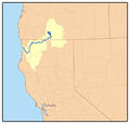 DescriptionKlamathRiver watershed.png Map of the Klamath River watershed in California and Oregon — Western United States. I, Pfly, made it, based on...(469 × 445 (54 KB)) - 05:05, 26 May 2023
 DescriptionKlamathRiver watershed (cropped).png English: Cropped and slightly rotated version of KlamathRiver watershed.png, which was made by Pfly based...(316 × 316 (45 KB)) - 05:05, 26 May 2023
 Plain North Cascades Klamath Mountains/California High North Coast Range Madrean Archipelago Northern Basin and Range Sonoran Basin and Range Acadian Plains...(1,600 × 1,012 (791 KB)) - 21:20, 19 August 2024
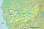 DescriptionRoguerivermap.png English: Map of the Rogue River — with tributary streams in its watershed—drainage basin. Flows from Cascade Range headwaters...(954 × 623 (1.09 MB)) - 07:47, 7 September 2020
 DescriptionRogue River Watershed.png English: A map of the Rogue River watershed, Oregon. Date 20 August 2010 Source Map taken from the Demis Map Server and modified...(1,459 × 809 (1.45 MB)) - 18:58, 20 October 2020
 province a. Puget Trough b. Olympic Mountains c. Oregon Coast Range d. Klamath Mountains e. California Trough f. California Coast Ranges g. Los Angeles...(1,264 × 830 (1.1 MB)) - 22:47, 16 August 2024


.png)


