
Search results
There is a page named "File:Karte Kanton Solothurn 2010.png" on Wikipedia
 English Map of the canton of Solothurn...(2,066 × 1,897 (1,009 KB)) - 05:02, 29 September 2021
 wikimedia.org/wikipedia/de/0/0c/Karte_Kanton_Tessin.png {{GFDL}} [[de:Bild:Karte Kanton Solothurn.png]] [[Category:Maps Uploaded with derivativeFX English...(535 × 795 (79 KB)) - 04:45, 30 September 2020
 DescriptionKarte Lage Kanton Solothurn 2010.png English: Canton Solothurn Deutsch: Kanton Solothurn Date 29 December 2009 Source Own work Author Tschubby...(4,133 × 2,770 (3.43 MB)) - 09:37, 6 September 2020
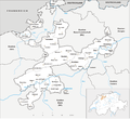
 DescriptionKarte Kanton Solothurn Bezirke 2010.png Deutsch: Bezirke des Kanton Solothurn Date 29 October 2009 Source Own work Author Tschubby Permission...(2,066 × 1,899 (909 KB)) - 09:09, 6 September 2020
 DescriptionKarte Kanton Solothurn Amtei 2010.png Deutsch: Amteien des Kanton Solothurn Date 29 October 2009 Source Own work Author Tschubby Permission...(2,066 × 1,899 (870 KB)) - 09:09, 6 September 2020
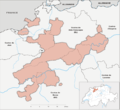 DescriptionKarte Kanton Solothurn Bezirke 2010 clair.png English: Fork from media:Karte Kanton Solothurn Bezirke 2010.png for geolocalisation Français :...(2,066 × 1,899 (662 KB)) - 20:54, 12 September 2020
 Übersichtskarte der Gemeinden des Bezirks Lebern, der Amtei Solothurn-Lebern, im Kanton Solothurn, in der Schweiz, dargestellt sind die zwei Hauptregionen...(800 × 450 (147 KB)) - 02:35, 30 September 2020
 DescriptionKarte Gemeinden des Kantons Solothurn 2010.png Municipalities in Canton Solothurn from 01.01.2010 to 31.12.2010 Date 1 January 2010 Source Own...(2,952 × 2,703 (1.67 MB)) - 12:12, 25 May 2024
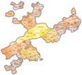 DescriptionKarte Gemeinden des Kantons Solothurn farbig 2010.png Municipalities in Canton Solothurn from 01.01.2010 to 31.12.2010 Date 1 January 2010 Source...(2,952 × 2,703 (2 MB)) - 12:11, 25 May 2024
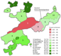 Solothurn 2010 09 26 Vorlage 05.png Deutsch: Abstimmungsergebnis der kantonalen Volksabstimmung im Kanton Solothurn vom 26. September 2010 über die...(2,952 × 2,701 (896 KB)) - 18:33, 12 August 2023
 Gemeinden des Kantons Solothurn leer 2012.png by Nightwish62, which in turn based on File:Karte Gemeinden des Kantons Solothurn farbig 2012.png by Tschubby Author...(2,952 × 2,265 (631 KB)) - 21:34, 21 October 2020


