
Search results
There is a page named "File:Ile de Clipperton (carte-fr).svg" on Wikipedia
 0-migrated, GFDL 2006-11-25T10:46:06Z Jost 559x389 (198343 Bytes) Carte ile de Clipperton source : fichier personnel déjà en ligne dte : 25/11/06 Auteur :...(2,070 × 1,686 (236 KB)) - 11:06, 11 October 2020
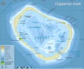 This image is a derivative work of the following images: File:Ile_de_Clipperton_(carte-fr).svg licensed with Cc-by-sa-2.5,2.0,1.0, Cc-by-sa-3.0-migrated,...(2,070 × 1,686 (237 KB)) - 11:07, 11 October 2020
 truetrue You may select the license of your choice. . File:Ile_de_Clipperton_(carte-fr).svg was uploaded with license I, the copyright holder of this work...(2,070 × 1,686 (237 KB)) - 06:22, 17 August 2024
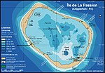 File:Carteactuelle.jpg (category Political maps of Clipperton Island)truetrue You may select the license of your choice. Derivative works of this file: Ile de Clipperton (carte-fr).svg English determination method: SHA-1...(559 × 389 (194 KB)) - 23:31, 5 February 2024
 0-migrated, GFDL 2006-11-25T10:46:06Z Jost 559x389 (198343 Bytes) Carte ile de Clipperton source : fichier personnel déjà en ligne dte : 25/11/06 Auteur :...(2,070 × 1,686 (379 KB)) - 19:06, 23 October 2021
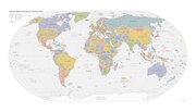 ) Français : Carte du monde selon le CIA World Factbook. Cette version de janvier 2015 est la dernière version vectorielle disponible de ce fichier. (La...(6,300 × 3,600 (23.25 MB)) - 11:31, 18 August 2024
.svg)
.svg)
.svg)

.svg)
