
Search results
There is a page named "File:Deutschland topo.png" on Wikipedia
 german wikipedia Made by: w:de:Benutzer:Captain Blood English Topographic map containing parts of Germany. German Karte mit Höhenangaben von Deutschland...(2,000 × 2,410 (6.11 MB)) - 19:23, 5 August 2024
 license: This image is a derivative work of the following images: File:Deutschland_topo.png licensed with GFDL 2005-02-28T13:26:04Z Schaengel89 1000x1205 (2284261...(596 × 720 (153 KB)) - 03:08, 26 October 2021
 the wine regions in Germany. Created with TheGimp based on Image:Deutschland_topo.png by Wikipedia User de:Benutzer:Captain_Blood. Key: 1. Ahr 2. Baden...(1,002 × 672 (211 KB)) - 21:41, 12 October 2020
 Topologiekarte (Thüringen) selbst erstellt ([[Benutzer:Wikiabg|WikiABG]]) Vorlagen: *[[:Bild:Deutschland topo.jpg]] *[[:Bild:Thuringia map.png]] English...(240 × 196 (27 KB)) - 19:26, 28 March 2021
 ([[Benutzer:Wikiabg|WikiABG]]) mit den Vorlagen: *[[:Bild:Deutschland topo.jpg]] *[[:Bild:Germany Laender Map.png]] English determination method: SHA-1...(529 × 374 (49 KB)) - 07:19, 4 August 2023
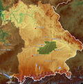 der Hallertau *Quelle: Karte von http://de.wikipedia.org/wiki/Bild:Deutschland_topo.jpg bearbeitet *Fotograf oder Zeichner: [[Benutzer:Eppasandas]] *Datum:...(1,052 × 1,072 (2.53 MB)) - 13:57, 3 June 2022
 Background is Image:Deutschland topo.jpg (), which is GNU; information on motorways comes from Image:Autobahn_1-999.png (). Information on the A22 itself...(2,211 × 1,102 (4.15 MB)) - 15:37, 8 October 2023
 license: This image is a derivative work of the following images: File:Deutschland_topo.jpg licensed with GFDL-GMT 2006-11-16T23:43:21Z Botaurus-stellaris...(805 × 547 (1.13 MB)) - 08:57, 8 October 2020
 |Beschreibung = Dämmerung in Deutschland am 21.juni |Quelle = selbst gezeichnet nach Vorlage: http://de.wikipedia.org/wiki/Datei:Deutschland_topo.jpg |Urheber = User...(661 × 862 (1.08 MB)) - 02:22, 20 September 2020
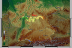 This PNG graphic was created with GIMP. English...(1,000 × 659 (1.17 MB)) - 11:16, 25 February 2024
 File:Beiträge zur Paläontologie des Asiatischen Russlands (IA BeitragezurPala00n).pdf (matches file content)diejenige berichtigende Vervollständigung zu geben, die einen in ihrer topo- graphischen Bestimmtheit mehr oder minder gewagten Ausdruck bereits auf...(1,404 × 1,833 (5.65 MB)) - 11:30, 10 November 2023
 Wasserturm Langeoog.jpg von Huebi – GFDL/CC-by-sa – (Langeoog, Niedersachsen) Image:Deutschland topo.jpg – GMT-Karte – GFDL – (Geographie Deutschlands) English...(18,129 × 250 (1.73 MB)) - 00:34, 10 September 2020
 DescriptionAltmark Jerichow topo.png Deutsch: Positionskarte von Sachsen-Anhalt, Deutschland English: Location map of Saxony-Anhalt, Germany Info This...(2,608 × 1,626 (3.59 MB)) - 14:25, 22 June 2024
 DescriptionMünsterland topo.jpg Deutsch: Karte des Münsterlandes in Nordrhein-Westfalen, Deutschland. Français : Carte du pays de Münster (Münsterland)...(4,000 × 3,157 (3.77 MB)) - 06:01, 18 August 2024
 DescriptionAltenburg Topo lat.jpg Topologiekarte (Altenburg) in Latin. German original made by: WikiABG) mit den Vorlagen: de:Bild:Deutschland topo.jpg de:Bild:Germany...(529 × 374 (54 KB)) - 07:19, 4 August 2023
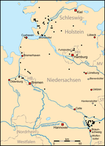 DescriptionVerteilung von Büttel-Orten in Deutschland.png Verteilung von Büttel-Orten in Norddeutschland Date April 2007 Source Own work Author Lencer...(865 × 1,200 (257 KB)) - 00:42, 13 June 2022
 DescriptionLage der kreisfreien Stadt Dortmund in Deutschland.PNG Lage der Stadt Dortmund in Nordrhein-Westfalen Date December 2007 Source own work, used...(176 × 234 (6 KB)) - 23:26, 13 May 2022
 Büttel-Orten in Deutschland.svg Verteilung von Büttel-Orten in Norddeutschland Date April 2007 Source Own work Author Lencer Other versions PNG-Version der...(423 × 563 (105 KB)) - 00:42, 13 June 2022
 gov/mgg/global/global.html GLOBE (topography): http://www.ngdc.noaa.gov/mgg/topo/gltiles.html SRTM (topography): http://www2.jpl.nasa.gov/srtm/ বাংলা ∙ English ∙...(1,500 × 1,089 (672 KB)) - 00:01, 7 January 2021
 DescriptionMain Würzburg.png Würzburg, eine Stadt am Main Date April 2007 Source "own work", used Deutschland topo.jpg Author Lencer...(865 × 359 (769 KB)) - 19:54, 25 April 2022


