
Search results
There is a page named "File:Carrefour Industrielle Alliance 04.JPG" on Wikipedia
 DescriptionCarrefour Industrielle Alliance 04.JPG Français : Carrefour Industrielle Alliance (autres noms : Magasin Simons, Édifice de l'industriel Alliance, Magasin...(5,152 × 3,864 (4.11 MB)) - 20:06, 4 February 2024
 DescriptionCarrefour Industrielle Alliance.JPG Français : Carrefour Industrielle Alliance (autres noms : Magasin Simons, Édifice de l'industriel Alliance, Magasin...(5,152 × 3,864 (1.78 MB)) - 20:06, 4 February 2024
 DescriptionCarrefour Industrielle Alliance 06.JPG Français : Carrefour Industrielle Alliance (autres noms : Magasin Simons, Édifice de l'industriel Alliance, Magasin...(5,152 × 3,864 (4.07 MB)) - 20:06, 4 February 2024
 DescriptionCarrefour Industrielle Alliance 01.JPG Français : Carrefour Industrielle Alliance (autres noms : Magasin Simons, Édifice de l'industriel Alliance, Magasin...(3,000 × 4,000 (1 MB)) - 20:06, 4 February 2024
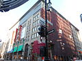 DescriptionCarrefour Industrielle Alliance 09.JPG Français : Carrefour Industrielle Alliance (autres noms : Magasin Simons, Édifice de l'industriel Alliance, Magasin...(5,152 × 3,864 (4.16 MB)) - 20:06, 4 February 2024
 DescriptionCarrefour Industrielle Alliance 05.JPG Français : À gauche : 1001, rue Sainte-Catherine Ouest / rue Metcalfe, Montréal imtl.org/vitrine À droite :...(5,152 × 3,864 (4.15 MB)) - 20:06, 4 February 2024
 Camera location 45° 30′ 04.24″ N, 73° 34′ 18.58″ W View this and other nearby images on: OpenStreetMap 45.501177; -73.571827...(4,608 × 3,456 (3.56 MB)) - 05:01, 18 February 2022
 Camera location 45° 30′ 04.53″ N, 73° 34′ 18.3″ W View this and other nearby images on: OpenStreetMap 45.501257; -73.571750...(4,608 × 3,456 (3.88 MB)) - 05:01, 18 February 2022
 Camera location 45° 30′ 04.24″ N, 73° 34′ 20.08″ W View this and other nearby images on: OpenStreetMap 45.501179; -73.572244...(1,500 × 1,033 (1.29 MB)) - 20:51, 23 May 2021
 Camera location 45° 30′ 04.24″ N, 73° 34′ 20.08″ W View this and other nearby images on: OpenStreetMap 45.501179; -73.572244...(961 × 1,500 (1.12 MB)) - 20:51, 23 May 2021
 Camera location 45° 30′ 04.24″ N, 73° 34′ 20.08″ W View this and other nearby images on: OpenStreetMap 45.501179; -73.572244...(960 × 1,500 (1.03 MB)) - 23:11, 29 June 2023


