
Search results
There is a page named "File:Cambodia provinces en.svg" on Wikipedia
 DescriptionCambodia provinces en.svg The provinces of Cambodia. Date 13 March 2014 Source Own work; derived from File:Cambodia provinces blank.png Author...(1,182 × 989 (328 KB)) - 05:53, 28 January 2024
 map of the provinces of Cambodia, useful for numbering/labelling for other languages. Made by User:Golbez, based on a map by Morwen on en.wikipedia.org...(2,000 × 1,613 (30 KB)) - 05:53, 28 January 2024
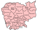 Map of the provinces of Cambodia, with ISO standard names. Carte des provinces du Cambodge utilisant la norme ISO pour les noms de lieux. Made by User:Golbez...(1,000 × 807 (154 KB)) - 05:53, 28 January 2024
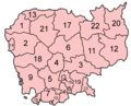 Map of the provinces of Cambodia. Made by User:Golbez based on a map by Morwen on en.wikipedia.org. English determination method: SHA-1...(400 × 323 (15 KB)) - 05:53, 28 January 2024
 provinces of Cambodia in Khmer, using names from the English Wikipedia. ខេត្ត កម្ពុជា Made by User:Golbez originally based on a map by Morwen on en.wikipedia...(1,000 × 807 (46 KB)) - 05:53, 28 January 2024
 DescriptionCambodia provinces en no text.svg English: The provinces of Cambodia without text. Date Original: 2014-03-13 Without text: 2023-11-26 Source...(1,182 × 989 (103 KB)) - 05:53, 28 January 2024
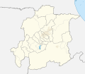 browse for more. FDFBEA → Marked territory F2F2F2 → Other state/provinces of Venezuela 656564 → Lines/boundaries C7E7FB → Waterbodies...(512 × 448 (1.8 MB)) - 02:45, 22 May 2024
 browse for more. FDFBEA → Marked territory F2F2F2 → Other state/provinces of Venezuela 656564 → Lines/boundaries C7E7FB → Waterbodies...(512 × 386 (1.4 MB)) - 23:54, 1 January 2024
 territory FDFBEA → Marked state/province F6E1B9 → Other state/provinces of Venezuela 656564 → Lines/boundaries C7E7FB → Water bodies...(512 × 593 (2.39 MB)) - 05:17, 9 June 2024
 browse for more. FDFBEA → Marked territory F2F2F2 → Other state/provinces of Venezuela DFDFDF → Other countries 656564 → Lines/boundaries...(512 × 684 (2.88 MB)) - 16:51, 8 June 2024
 browse for more. FDFBEA → Marked territory F6E1B9 → Other state/provinces of Venezuela 656564 → Lines/boundaries C7E7FB → Waterbodies...(512 × 448 (1.8 MB)) - 00:00, 2 January 2024
 browse for more. FDFBEA → Marked territory F6E1B9 → Other state/provinces of Venezuela 656564 → Lines/boundaries C7E7FB → Waterbodies...(512 × 386 (1.4 MB)) - 23:54, 1 January 2024
 browse for more. FDFBEA → Marked territory F2F2F2 → Other state/provinces of Venezuela 656564 → Lines/boundaries 45C5ED → Rivers ...(512 × 386 (556 KB)) - 23:56, 1 January 2024
 browse for more. FDFBEA → Marked territory F6E1B9 → Other state/provinces of Venezuela DFDFDF → Other countries 656564 → Lines/boundaries...(512 × 684 (2.88 MB)) - 16:50, 8 June 2024
 territory FDFBEA → Marked state/province F6E1B9 → Other state/provinces of Venezuela 656564 → Lines/boundaries C12836 → Marked state/province...(512 × 386 (553 KB)) - 05:17, 9 June 2024
 territory FDFBEA → Marked state/province F6E1B9 → Other state/provinces of Venezuela 656564 → Lines/boundaries C7E7FB → Water bodies...(512 × 593 (2.39 MB)) - 05:17, 9 June 2024
 browse for more. FDFBEA → Marked territory F2F2F2 → Other state/provinces of Venezuela DFDFDF → Other countries 656564 → Lines/boundaries...(512 × 209 (1.77 MB)) - 22:47, 7 March 2024
 territory FDFBEA → Marked state/province F6E1B9 → Other state/provinces of Venezuela 656564 → Lines/boundaries C12836 → Marked state/province...(512 × 386 (553 KB)) - 05:17, 9 June 2024
 territory FDFBEA → Marked state/province F6E1B9 → Other state/provinces of Venezuela 656564 → Lines/boundaries C12836 → Marked state/province...(512 × 386 (553 KB)) - 05:17, 9 June 2024
 territory FDFBEA → Marked state/province F6E1B9 → Other state/provinces of Venezuela 656564 → Lines/boundaries C12836 → Marked state/province...(512 × 386 (553 KB)) - 05:17, 9 June 2024


