
Search results
There is a page named "File:BuckinghamshireChiltern.png" on Wikipedia
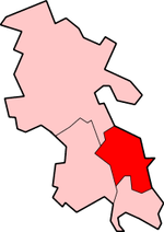 Chiltern district in Buckinghamshire Created by en:User:Morwen English determination method: SHA-1...(200 × 282 (17 KB)) - 05:58, 29 December 2023
 1070x1266 (574562 Bytes) {{Information |Description=Map of [[w:Buckinghamshire|Buckinghamshire]], UK with districts shown. Equirectangular map projection...(335 × 520 (50 KB)) - 05:57, 29 December 2023
 This image is a derivative work of the following images: File:Chiltern_Main_Line_map.png licensed with PD-self 2008-06-30T12:48:18Z APHST 866x761 (116566...(866 × 772 (16 KB)) - 09:50, 27 February 2024
 com/photos/citytransportinfo/37281283830/ operator: Flickr URL: https://live.staticflickr.com/4450/37281283830_dfd483612c_o.png determination method: 0702186578...(1,500 × 1,066 (3.56 MB)) - 09:53, 21 June 2024
 the year [[2005]] and donate it to the public domain. {{category: Transportation}} {{category: Railway lines}} {{category: Buckinghamshire}} English...(1,756 × 1,212 (4.75 MB)) - 20:16, 17 February 2024
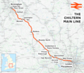 DescriptionChiltern Main Line.png The Chiltern Main Line This map was created from OpenStreetMap project data, collected by the community. This map may...(2,098 × 1,822 (4.17 MB)) - 09:49, 27 February 2024
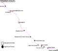 DescriptionChiltern Main Line map.png English: A geographically accurate map of the Chiltern Main Line complete with major and significant stations Date...(866 × 761 (114 KB)) - 09:50, 27 February 2024
 DescriptionBuckinghamshireNumbered.png English: Map of Buckinghamshire with Districts numbered South Bucks Chiltern Wycombe Aylsebury Vale Date 8 February...(200 × 282 (3 KB)) - 05:58, 29 December 2023
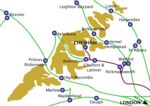 DescriptionBuckinghamshire railways 2000.png Railways in central Buckinghamshire, 2000. Metropolitan Railway services highlighted in purple. Date 12 October...(1,053 × 745 (166 KB)) - 06:00, 29 December 2023
 DescriptionBuckinghamshire railways, 1880.png Railways in central and southern Buckinghamshire and important towns without rail connections, 1880. Only...(1,053 × 745 (171 KB)) - 06:00, 29 December 2023
 DescriptionPitstone Hill October 2020.png English: Pitstone Hill in the Chiltern Hills, looking towards Ivinghoe, Buckinghamshire. Date 11 October 2020 Source...(2,560 × 1,536 (3.27 MB)) - 07:12, 19 October 2020
 e) Windsor and Maidenhead U.A. f) Slough U.A. Buckinghamshire 2. Buckinghamshire a) South Bucks, b) Chiltern, c) Wycombe, d) Aylesbury Vale 3. Milton Keynes...(1,425 × 1,141 (2.25 MB)) - 23:00, 28 May 2023


.png)


