
File:Brands Hatch.png

Size of this preview: 466 × 599 pixels. Other resolutions: 187 × 240 pixels | 373 × 480 pixels | 597 × 768 pixels | 1,133 × 1,457 pixels.
Original file (1,133 × 1,457 pixels, file size: 302 KB, MIME type: image/png)
| This is a file from the Wikimedia Commons. Information from its description page there is shown below. Commons is a freely licensed media file repository. You can help. |
Summary
| Description |
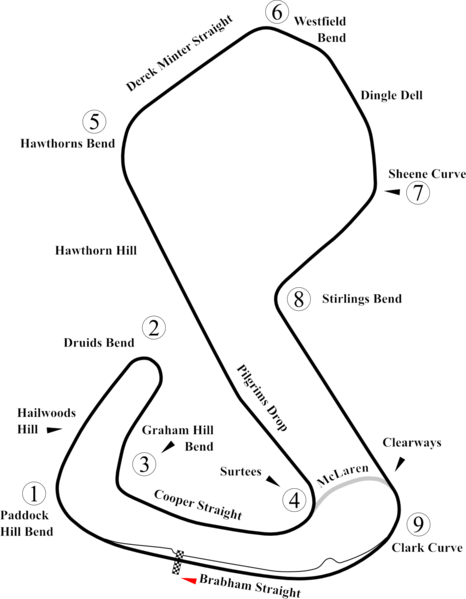
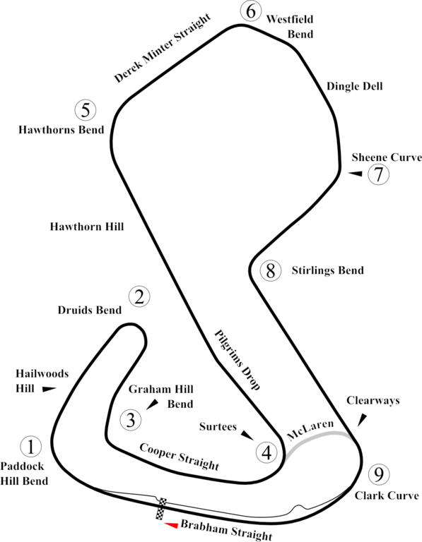
English: Track map of Brands Hatch. This PNG version is intended for use with browsers like IE7 that don't support SVG. |
| Date | |
| Source | Own work |
| Author | Will Pittenger |
| Other versions |
|

| Camera location | | View this and other nearby images on: OpenStreetMap |
|---|
Licensing
| I, the copyright holder of this work, release this work into the public domain. This applies worldwide. In some countries this may not be legally possible; if so: I grant anyone the right to use this work for any purpose, without any conditions, unless such conditions are required by law. |
File history
Click on a date/time to view the file as it appeared at that time.
| Date/Time | Thumbnail | Dimensions | User | Comment | |
|---|---|---|---|---|---|
| current | 15:06, 7 July 2012 | | 1,133 × 1,457 (302 KB) | Aegidian | Minor corrections to the names of Hawthorns Bend and Derek Minter straight, removal of old Dingle Dell Corner and replacement with current Sheene Curve. |
| 06:40, 15 July 2008 |  | 1,198 × 1,457 (294 KB) | Will Pittenger | {{Information |Description={{en|1=Track map of w:Brands Hatch. This PNG version is intended for use with browsers like IE7 that don't support SVG.}} |Source=Own work by uploader |Author=Will Pittenger |Date=7-15-2008 |Permiss |
File usage
The following pages on the English Wikipedia use this file (pages on other projects are not listed):
- User talk:4u1e/archive5
- User talk:Bam123456789/Archive 1
- User talk:Barkjon/Archive 2
- User talk:Cdhaptomos/Archive 1
- User talk:Chubbennaitor/Archive7
- User talk:Chubbennaitor/archive2
- User talk:Clyde1998/Archive/2008
- User talk:Cs-wolves/Archive 3
- User talk:Donnie Park/Archive 1
- User talk:Hellboy2hell/archive2
- User talk:Midgrid/Archive 6
- User talk:NapHit/Archive 1
- User talk:Readro/Archive 3
- User talk:Sage Callahan/Archive 1
- User talk:Spenalzo/Archive/2008
- User talk:The359/Archive 4
- User talk:Thelb4/Archive 5
- User talk:Typ932/Archive 3
- Wikipedia:WikiProject Formula One/Newsletter/200808
Global file usage
The following other wikis use this file:
- Usage on bg.wikipedia.org
- Usage on bs.wikipedia.org
- Usage on ca.wikipedia.org
- Usage on cs.wikipedia.org
- Usage on fr.wikipedia.org
- Usage on hu.wikipedia.org
- Usage on it.wikipedia.org
- Usage on sl.wikipedia.org