
Search results
There is a page named "File:Blank map of Europe (without disputed regions).svg" on Wikipedia
 DescriptionBlank map of Europe (without disputed regions).svg English: A political Map of Europe in SVG format without disputed areas and conflict regions. Date...(680 × 520 (645 KB)) - 20:42, 6 May 2024
 truetrue This image is a derivative work of the following images: File:Blank map of Europe (without disputed regions).svg licensed with Cc-by-sa-4.0 2015-04-20T17:54:10Z...(512 × 392 (321 KB)) - 03:52, 14 July 2024
 https://creativecommons.org/licenses/by-sa/4.0CC BY-SA 4.0 Creative Commons Attribution-Share Alike 4.0 truetrue English Map of Europe without disputed regions...(6,577 × 6,967 (504 KB)) - 06:17, 10 March 2023
 truetrue This image is a derivative work of the following images: File:Blank map of Europe (without disputed regions).svg licensed with Cc-by-sa-4.0 2021-09-06T08:06:41Z...(512 × 392 (344 KB)) - 07:38, 4 November 2022
 народів по Європі. Для створення використано файл Blank map of Europe (without disputed regions).svg та програму Inkscape author name string: Artenovis9020...(680 × 520 (651 KB)) - 00:57, 29 July 2024
 BY-SA 3.0 Creative Commons Attribution-Share Alike 3.0 truetrue English European Countries Simple English grafische Darstellung der Länder Europas in ihren...(680 × 520 (795 KB)) - 00:20, 5 July 2024
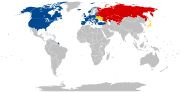 English World map showing CSTO and NATO member states with disputed regions as of July 2022 determination method: SHA-1...(2,754 × 1,398 (1.1 MB)) - 09:19, 19 August 2024
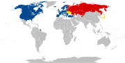 English World map showing CSTO and NATO member states with disputed regions author name string: JayCoop URL: https://commons.wikimedia.org/wiki/User:JayCoop...(2,754 × 1,398 (1.11 MB)) - 07:12, 10 March 2024
 DescriptionEurope blank map without disputed regions.png English: Map of Europe without disputed regions Español: Mapa de Europa sin regiones en disputa...(2,021 × 2,048 (500 KB)) - 12:40, 2 July 2023
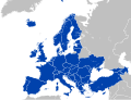 org/licenses/by-sa/4.0CC BY-SA 4.0 Creative Commons Attribution-Share Alike 4.0 truetrue English Map of participating states in the European Political Community...(680 × 520 (651 KB)) - 14:12, 3 October 2023
 625 Europe 799 20 527 399 1480 625 Asia 1140 359 339 242 1480 625 Oceania 6 372 255 235 1480 625 Oceania English A blank map of the world as of 2022...(1,500 × 740 (39 KB)) - 08:17, 27 March 2024
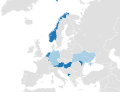 Attribution-Share Alike 4.0 truetrue English Map of parties and signatories to the Council of Europe Convention on the Avoidance of Statelessness in Relation to State...(680 × 520 (656 KB)) - 02:57, 22 April 2024
 Creative Commons Attribution-Share Alike 4.0 truetrue English Map of the Council of Europe member states by founding members, later members and former members...(680 × 520 (647 KB)) - 18:53, 16 March 2022
 overwrite this file from the same source. Read COM:OVERWRITE first. English Map of Europe with NATO member states shaded green and Serbia shaded orange...(680 × 520 (647 KB)) - 21:10, 7 March 2024
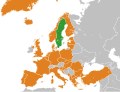 overwrite this file from the same source. Read COM:OVERWRITE first. English Map of Europe with NATO member states shaded green and Sweden shaded orange determination...(680 × 520 (647 KB)) - 16:14, 21 July 2024
 I, the copyright holder of this work, hereby publish it under the following license: English...(680 × 520 (646 KB)) - 22:03, 6 September 2020
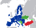 4.0 Creative Commons Attribution-Share Alike 4.0 truetrue English Map of European Union members and membership candidates Russian Карта членов Европейского...(680 × 520 (659 KB)) - 01:46, 6 August 2024
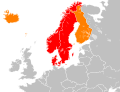 Commons Attribution-Share Alike 4.0 truetrue English Map showing two of the common definitions of "Scandinavia" Swedish Karta visande de två mest förekommande...(680 × 520 (645 KB)) - 21:21, 8 November 2023
 I, the copyright holder of this work, hereby publish it under the following license: This file is licensed under the Creative Commons Attribution-Share...(389 × 373 (687 KB)) - 05:41, 11 May 2023
 adding disputed areas, fixing french polynesia, (may need adjusting) 2010-02-01T03:10:44Z R-41 1425x625 (31271 Bytes) Since Kosovo is shown as a disputed territory...(1,500 × 740 (41 KB)) - 22:46, 1 April 2024
.svg)


.svg)


