
Search results
There is a page named "File:2014 Pacific typhoon season summary.png" on Wikipedia
 Description2014 Pacific typhoon season summary.png English: This map shows the tracks of all tropical cyclones in the 2014 Pacific typhoon season. The points...(4,000 × 3,000 (7.6 MB)) - 14:09, 19 April 2023
 Philippines, then returned to same spot after typhoon season ends 4121 1455 126 84 4792 2604 3. Pacific Ocean crossing ends at Finsch Harbor, Papua New...(4,792 × 2,604 (2.54 MB)) - 11:31, 18 August 2024
 DescriptionNuri 2014 full track.png English: Track map of Typhoon Nuri of the 2014 Pacific typhoon season. The points show the location of the storm at...(2,700 × 2,448 (2.23 MB)) - 18:12, 27 February 2023
 DescriptionFaxai 2014 track.png English: Track map of Typhoon Faxai of the 2014 Pacific typhoon season. The points show the location of the storm at 6-hour...(2,700 × 1,669 (107 KB)) - 18:19, 27 February 2023
 Description1972 Pacific typhoons on July 13.png English: Montage of five concurrent typhoons over the Western Pacific on July 13, 1972 Date 28 June 2014, 07:21:32...(1,204 × 558 (614 KB)) - 12:39, 17 August 2024
 DescriptionMitag 2014 track.png English: Track map of Tropical Storm Mitag of the 2014 Pacific typhoon season. The points show the location of the storm...(2,700 × 1,669 (2.5 MB)) - 18:23, 27 February 2023
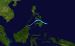 DescriptionJangmi 2014 track.png English: Track map of Tropical Storm Jangmi of the 2014 Pacific typhoon season. The points show the location of the storm...(2,700 × 1,669 (2.55 MB)) - 18:21, 27 February 2023
 DescriptionRammasun 2014 track.png English: Track map of Typhoon Rammasun of the 2014 Pacific typhoon season. The points show the location of the storm...(2,700 × 1,669 (2.38 MB)) - 22:37, 29 January 2024
 DescriptionKalmaegi 2014 track.png English: Track map of Typhoon Kalmaegi of the 2014 Pacific typhoon season. The points show the location of the storm...(2,700 × 1,669 (2.84 MB)) - 18:22, 27 February 2023
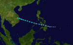 DescriptionSinlaku 2014 track.png English: Track map of Tropical Storm Sinlaku of the 2014 Pacific typhoon season. The points show the location of the...(2,700 × 1,669 (3.07 MB)) - 18:24, 27 February 2023
 DescriptionPeipah 2014 track.png English: Track map of Tropical Storm Peipah of the 2014 Pacific typhoon season. The points show the location of the storm...(2,700 × 1,669 (1.24 MB)) - 18:23, 27 February 2023
 DescriptionNeoguri 2014 track.png English: Track map of Typhoon Neoguri of the 2014 Pacific typhoon season. The points show the location of the storm...(2,700 × 2,700 (4 MB)) - 18:23, 27 February 2023
 DescriptionTapah 2014 track.png English: Track map of Severe Tropical Storm Tapah of the 2014 Pacific typhoon season. The points show the location of...(2,700 × 1,669 (236 KB)) - 18:24, 27 February 2023
 DescriptionJMA TD 08 2014 track.png English: Track map of JMA Tropical Depression Eight of the 2014 Pacific typhoon season. The points show the location...(2,700 × 1,669 (845 KB)) - 18:21, 27 February 2023
 DescriptionCaloy 2014 track.png English: Track map of Tropical Depression Caloy of the 2014 Pacific typhoon season. The points show the location of the...(2,700 × 1,669 (2.16 MB)) - 21:06, 27 January 2024
 DescriptionKajiki 2014 track.png English: Track map of Tropical Storm Kajiki of the 2014 Pacific typhoon season. The points show the location of the storm...(2,700 × 1,669 (1.32 MB)) - 18:22, 27 February 2023
 DescriptionLingling 2014 track.png English: Track map of Tropical Storm Lingling of the 2014 Pacific typhoon season. The points show the location of the...(2,700 × 1,669 (1.56 MB)) - 18:22, 27 February 2023
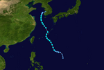 DescriptionNakri 2014 track.png English: Track map of Severe Tropical Storm Nakri of the 2014 Pacific typhoon season. The points show the location of...(2,700 × 1,812 (2.86 MB)) - 18:23, 27 February 2023
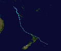 DescriptionJune 2014 track.png English: Track map of Tropical Cyclone June of the 2013-14 South Pacific cyclone season. The points show the location of...(2,700 × 2,268 (796 KB)) - 12:31, 2 September 2023
 DescriptionMike 2014 track.png English: Track map of Tropical Cyclone Mike of the 2013-14 South Pacific cyclone season. The points show the location of...(2,700 × 2,178 (232 KB)) - 12:32, 2 September 2023


