
File:1918 British Government Map illustrating Territorial Negotiations between H.M.G. and King Hussein.png
No higher resolution available.
1918_British_Government_Map_illustrating_Territorial_Negotiations_between_H.M.G._and_King_Hussein.png (508 × 546 pixels, file size: 489 KB, MIME type: image/png)
| This is a file from the Wikimedia Commons. Information from its description page there is shown below. Commons is a freely licensed media file repository. You can help. |
Summary
| Description |
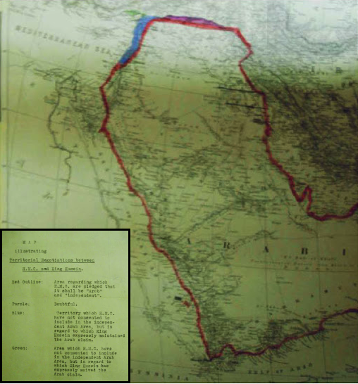
العربية: خريطة تعود لعام 1918 توضح الحدود الإقليمية للاراضي التي طالب بها الشريف الحسين أثناء المراسلات مع مكماهون
English: MPK 1/410 extracted from FO 371/4368; (7) Larger printed map, showing additionally the whole Arabian peninsula. Reference table. Scale: 1:6,969,600. Ms additions, coloured, mark several areas under discussion. Title affixed: 'Map illustrating Territorial Negotiations between H.M.G. amd King Hussein'; reference table to additions affixed. |
| Date | |
| Source | National Archives: http://discovery.nationalarchives.gov.uk/details/r/C3980431 |
| Author | UK Government |
Licensing
Note: This map is not in copyright, since UK Crown Copyright for such materials expires 50 years after publication.
This work created by the United Kingdom Government is in the public domain.
This is because it is one of the following:
HMSO has declared that the expiry of Crown Copyrights applies worldwide (ref: HMSO Email Reply)
|
 |
File history
Click on a date/time to view the file as it appeared at that time.
| Date/Time | Thumbnail | Dimensions | User | Comment | |
|---|---|---|---|---|---|
| current | 21:54, 8 November 2016 | | 508 × 546 (489 KB) | Onceinawhile | User created page with UploadWizard |
File usage
The following pages on the English Wikipedia use this file (pages on other projects are not listed):
Global file usage
The following other wikis use this file:
- Usage on ar.wikipedia.org
- Usage on azb.wikipedia.org
- Usage on az.wikipedia.org
- Usage on es.wikipedia.org
- Usage on fa.wikipedia.org
- Usage on fr.wikipedia.org
- Usage on gl.wikipedia.org
- Usage on hr.wikipedia.org
- Usage on id.wikipedia.org
- Usage on ko.wikipedia.org
- Usage on ml.wikipedia.org
- Usage on nl.wikipedia.org
- Usage on ru.wikipedia.org
- Usage on sr.wikipedia.org