
Barabanki
Barabanki | |
|---|---|
City | |
   | |
 Barabanki Location in Uttar Pradesh, India  Barabanki Barabanki (India) | |
| Coordinates: 26°55′N 81°12′E / 26.92°N 81.2°E | |
| Country | |
| State | Uttar Pradesh |
| Region | Awadh |
| Division | Ayodhya |
| District | Barabanki |
| Government | |
| • Type | Municipal Board |
| • Body | Barabanki Municipal Council |
| • District Magistrate and Collector | Avinash Kumar, IAS |
| Area | |
| • Total | 45 km2 (17 sq mi) |
| Elevation | 100 m (300 ft) |
| Population (2011) | |
| • Total | 146,831 |
| • Density | 331/km2 (860/sq mi) |
| Language | |
| • Official | Hindi[1] |
| • Additional official | Urdu[1] |
| • Literacy | 80% |
| Time zone | UTC+5:30 (IST) |
| PIN | 225 001 |
| Telephone code | 05248 |
| Vehicle registration | UP-41 |
| District Magistrate | Adarsh Singh, IAS |
| Website | barabanki |
Barabanki is a city and a municipal board in the Indian state of Uttar Pradesh. It is the administrative headquarters of Barabanki district and a part of Ayodhya division. The city is about 30 km east of Lucknow, the state capital. It has a population of 146,831 with a density of 331.00 per square kilometre (860.0/sq mi).
History
This article may require cleanup to meet Wikipedia's quality standards. The specific problem is: The section uses British Raj Era sources, not considered reliable in Wikipedia. (April 2022) |
The Barabanki district was first established by the British upon their annexation of Oudh State in 1856.[2] Originally, the district was known as Daryabad district because its headquarters were at Daryabad, but in 1859 they were relocated to Barabanki.[2] The name "Barabanki" was chosen for the district's official name over "Nawabganj", then the more common name of the town, for two reasons: first, to avoid any possible confusion with other places called Nawabganj, and second, because the civil station was technically located outside of Nawabganj in the small revenue village of Barabanki.[2] Previously, under the Nawabs of Awadh, the area that would become Barabanki district was divided among five chaklas: Daryabad-Rudauli, Ramnagar, Dewa-Jahangirabad, Jagdispur, and Haidargarh.[2]
Geography
Climate
Barabanki has tropical savanna climate (koppen Aw). The summers here are extremely hot due to proximity to tropics. The temperatures in the summer soar up to 40 to 45 degree celsius. Monsoon last from mid June to mid September. Winters are mild as it has tropical climate. In winters day time temperature rises up to 26 to 29, and at night drop up to 11 degrees.
| Climate data for Barabanki, Uttar Pradesh (1989–2010, extremes 1989–2010) | |||||||||||||
|---|---|---|---|---|---|---|---|---|---|---|---|---|---|
| Month | Jan | Feb | Mar | Apr | May | Jun | Jul | Aug | Sep | Oct | Nov | Dec | Year |
| Record high °C (°F) | 29.0 (84.2) |
35.5 (95.9) |
40.5 (104.9) |
44.5 (112.1) |
45.5 (113.9) |
47.0 (116.6) |
44.5 (112.1) |
38.0 (100.4) |
38.4 (101.1) |
38.0 (100.4) |
35.5 (95.9) |
30.5 (86.9) |
47.0 (116.6) |
| Mean daily maximum °C (°F) | 21.8 (71.2) |
26.1 (79.0) |
31.9 (89.4) |
38.0 (100.4) |
39.0 (102.2) |
37.2 (99.0) |
33.8 (92.8) |
33.0 (91.4) |
32.8 (91.0) |
32.8 (91.0) |
29.2 (84.6) |
24.4 (75.9) |
31.7 (89.1) |
| Mean daily minimum °C (°F) | 8.0 (46.4) |
10.9 (51.6) |
15.1 (59.2) |
20.1 (68.2) |
24.2 (75.6) |
26.0 (78.8) |
26.2 (79.2) |
25.9 (78.6) |
24.7 (76.5) |
20.0 (68.0) |
13.8 (56.8) |
9.2 (48.6) |
18.7 (65.7) |
| Record low °C (°F) | 2.0 (35.6) |
3.0 (37.4) |
7.5 (45.5) |
8.7 (47.7) |
15.7 (60.3) |
20.3 (68.5) |
22.2 (72.0) |
20.6 (69.1) |
17.5 (63.5) |
13.0 (55.4) |
6.3 (43.3) |
2.0 (35.6) |
2.0 (35.6) |
| Average rainfall mm (inches) | 16.0 (0.63) |
15.9 (0.63) |
7.7 (0.30) |
6.6 (0.26) |
38.8 (1.53) |
122.2 (4.81) |
236.3 (9.30) |
191.4 (7.54) |
170.4 (6.71) |
36.2 (1.43) |
5.9 (0.23) |
9.1 (0.36) |
856.5 (33.72) |
| Average rainy days | 1.2 | 1.6 | 0.9 | 0.6 | 2.4 | 5.5 | 10.9 | 9.5 | 7.0 | 1.5 | 0.4 | 0.6 | 42.0 |
| Average relative humidity (%) (at 17:30 IST) | 62 | 52 | 41 | 33 | 41 | 55 | 74 | 78 | 77 | 66 | 61 | 63 | 59 |
| Source: India Meteorological Department[3] | |||||||||||||
Demographics
As per provisional data of the 2011 census, the Barabanki urban agglomeration had a population of 146,831, with 77,766 males and 69,065 females. The literacy rate was 81.85%.[4]
Barabanki District is classified by the national government as a "Minority Concentrated District in India"[5] and Barabanki city is classified as a Muslim-majority city in the government files.[6]
Administration
Barabanki city comprises:
- Barabanki village (revenue village)
- Nawabganj (tehsil)
- Banki (town area)
- Barel (village)
- Satrikh (village)
- Kurauli (village)
- 252 Bomb Disposal Company (cantonment)[7]
- Suburbs
Places of interest
Transport
By road
National Highway 28 (NH-28) passes through the district. It is well connected to other cities by means of roadways. Passenger road transport services in Uttar Pradesh started in 1947 with the operation of bus service on the Lucknow–Ayodhya-Gorakhpur route by UP Government Roadways.[8]
- National Highway 27 (India)
- Barabanki-Lakhimpur (NH727H)
- Barabanki-Nepalganj Border (NH927)
- Lucknow-Ayodhya-Gorkhapur-Guwahati Highway (NH27)
Expressway
Purvanchal Expressway is an 340 km long, 6 lane wide (expandable to 8) greenfield expressway project in the state of Uttar Pradesh, India. It will pass through 9 districts including Barabanki.
By rail

Barabanki Junction railway station is the intercity rail station and a commuter rail hub in the Indian city of Barabanki. It has been important junction since the days of British control of India.[9] In its category it is one of the important stations in NER. The Barabanki Junction railway station is on the Delhi– Basti– Gorakhpur main broad-gauge route in Uttar Pradesh. Barabanki Junction is also the hub for the Barabanki–Lucknow Suburban Railway. Barabanki railway station lies in the zone of high density stations.[10]
By air
The nearest airport to Barabanki is Chaudhary Charan Singh International Airport at Amausi, Lucknow which is approximately 40 km from Barabanki.
Education
Schools and intermediate colleges
- Government Inter College, Barabanki city
- Jawahar Navodaya Vidyalaya, Sonikpur, Trivediganj, Barabanki
- Saraswati Shishu Mandir, Barabanki city
- Saraswati Vidya Mandir Inter College, Barabanki city
Engineering colleges
- Jahangirabad Institute of Technology, Jahangirabad
- Sagar Institute of Technology & Management, Faizabad Road
Polytechnic institute
- Government Polytechnic Barabanki, Jahangirabad Road
Other professional institutions
- Jahangirabad Media Institute, Jahangirabad
Research institutions
- International Rice Research Institute - branch Tikarhar Road, Kursi, Barabanki[11]
Notable people
- Khumar Barabankvi, poet
- Suroor Barabankvi, poet
- Inayat Ahmad Kakorvi, Islamic scholar and freedom fighter
- Mohsina Kidwai, politician
- Rafi Ahmed Kidwai, politician
- C. M. Naim, scholar of Urdu language and literature
- Naseeruddin Shah, film actor
- Waris Ali Shah, Sufi Saint
- K. D. Singh, hockey player
- Beni Prasad Verma, politician, Member of Parliament
- Ram Sewak Yadav, politician and member of parliament
Gallery
-
 Barabanki UPSRTC Bus Station
 -
 Exterior of Barabanki Jn Railway Station
 -
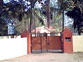
 Office of District Magistrate/Collector
 -
 Barabanki Head Post Office
 -
 Barabanki Kotwaali
 -
 Office of Tehsildar of Tehsil Nawabganj, Barabanki on Lucknow-Faizabad Road (NH-28)
 -
 Nagar Parishad Nawabganj
 -
 Shahid Smarak (a World War II memorial)
 -
 Statue of Mahatma Gandhi at Baapu Bhawan at Dewa Road
 -
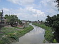 Jamuriya Nala (a brook) from Railway Station Road Bridge. This brook flows through the city and divides it into two halves.
 -
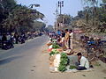 Evening vegetable bazaar along Court Road
 -
 Exterior of Dhanokhar Mandir (a temple dedicated primarily to Lord Hanuman) from Dhanokhar Chauraha. This temple has a moderate sized pond at its back.
 -
 Shree Nag Devta Temple during Manjitha Fair on the day of Naga Panchami
 -

-


_procession_Barabanki_India_(Jan_2009).jpg)

References
- ^ a b "52nd Report of the Commissioner for Linguistic Minorities in India" (PDF). nclm.nic.in. Ministry of Minority Affairs. Archived from the original (PDF) on 25 May 2017. Retrieved 21 December 2018.
- ^ a b c d Nevill, H.R. (1903). Bara Banki: A Gazetteer, Being Volume XLVIII Of The District Gazetteers Of The United Provinces Of Agra And Oudh. Allahabad: Government Press. pp. 125–8, 162–3. Retrieved 15 April 2021.
- ^ "Station: Barabanki Climatological Table 1981–2010" (PDF). Climatological Normals 1981–2010. India Meteorological Department. January 2015. pp. 95–96. Archived from the original (PDF) on 5 February 2020. Retrieved 6 May 2020.
- ^ "Urban Agglomerations/Cities having population 1 lakh and above" (PDF). Provisional Population Totals, Census of India 2011. Archived (PDF) from the original on 13 November 2011. Retrieved 7 July 2012.
- ^ "Identification of Minority Concentration Districts". Press Information Bureau (Government of India). 22 June 2007. Archived from the original on 28 October 2009. Retrieved 31 October 2009.
- ^ Ashok, Akash Deep (6 December 2013). "Babri Masjid anniversary: A few more things that were demolished that day". India Today. New Delhi. Archived from the original on 6 December 2013. Retrieved 7 December 2013.
- ^ "252 Bomb disposal Company (Barabanki)". Wikimapia.org. Archived from the original on 5 October 2012. Retrieved 17 June 2012.
- ^ "UPSRTC". Archived from the original on 4 January 2010. Retrieved 27 October 2009. UPSRTC History
- ^ India Railway Police Committee (1921). "India Railway Police Committee Report, Volumes 1-2". Printed at the Government Monotype Press. p. 277. Retrieved 30 June 2013.
- ^ "Transport Geography of Uttar Pradesh, Issue 2 of N.G.S.I. research publication". 1966. National Geographical Society of India. 1966. p. 44. Retrieved 30 June 2013.
- ^ Singh, Neelam; Pathak, M. D.; Zaidi, Najam W.; Singh, H. N.; Srivastava, P. C.; Singh, U. S. (2007). "Natural Biodiversity for Salinity and Alkalinity Tolerance in Scented Rice Cultivar Kalanamak". Journal of Crop Improvement. 20 (1–2): 205–221. doi:10.1300/J411v20n01_12. S2CID 82779666.