
Vihorlat Mountains


Vihorlat Mountains (Slovak: Vihorlatské vrchy; Ukrainian: Вигорлат, Vyhorliat, Hungarian: Vihorlát) or colloquially Vihorlat is a volcanic mountain range in eastern Slovakia and western Ukraine. A part of the range is listed as a World Heritage Site.
Etymology
The name is of Slavic origin.[1][2] Jozef Martinka suggested the origin in Ruthenian vyharj / vyhar (Slovak: výhor) - a burned forest with a groupping suffix -ať. Vygarljať, Vyhorljať - a mountain with many burned places. The Hungarian name Vihorlát derives from Slovak as an intermediate language.[1]
Vihorlat Mountains in Slovakia
The Slovak part is 55 km long, up to 11 km broad and from 400 to 1,076 m high. It belongs to the Vihorlat-Gutin Area group of the Inner Eastern Carpathian Mountains. The middle part of the mountains is protected by the Vihorlat Protected Landscape Area.
Vihorlat is bordered by the Eastern Slovak Lowland (Východoslovenská nížina) in the south and the west. The Beskidian Southern Piedmont (Beskydské predhorie) separates Vihorlat from the Bukovské vrchy mountains and Laborecká vrchovina highlands in the north. The highest peak is Vihorlat at 1,076 m AMSL. The largest lake in the mountain range is Morské oko, which is situated at 618 m AMSL.
World Heritage Site
Kyjovský prales, a primeval beech forest in Vihorlat Mountains, was proclaimed by UNESCO to be a World Heritage Site on June 28, 2007, because of its comprehensive and undisturbed ecological patterns and processes.[3]
Gallery
-
 Vihorlat (1,076 m), the highest mountain of Vihorlat Mountains
 -
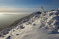
 Pylon on top of Vihorlat with rime
 -
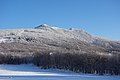
 Vihorlat in winter, in the background High Tatras
 -
 Winter in Vihorlat (left peak Kyjov)
 -
 Sninský kameň (1,006 m)
 -
 View of Morské oko from Sninský kameň
 -
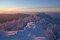 Sninský kameň in winter at sunset
 -
 Sninský kameň in autumn
 -
 Morské oko and peak Sninský kameň
 -
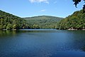
 Morské oko in May
 -
-

_002.jpg)
_007.jpg)
_034.jpg)
_046.jpg)
_015.jpg)
_026.jpg)
_046.jpg)


_008.jpg)


Panorama

See also
References
- ^ a b Martinka, Jozef (1940). "O názve Vihorlátu". Slovenská reč (in Slovak) (5–6). Matica slovencká: 142.
- ^ Kiss, Lajos (1978). Földrajzi nevek etimológiai szótára [Etymological Dictionary of Geographic Names] (in Hungarian). Budapest: Akadémiai. p. 694.
- ^ unesco.org
External links
- Chránená krajinná oblasť Vihorlat (in Slovak)
- Protected Landscape Area Vihorlat at Slovakia.travel
- Photo gallery Vihorlat, Photo gallery Sninský kameň, Photo gallery Inversion – Vihorlat, Sninský kameň (photos of Vihorlat and Sninský kameň)
- Distant sights from Vihorlat Mountains on the portal Na obzore (in Slovak)
- "Fotografie Vihorlat" (in Czech). Archived from the original on 2009-10-26.
48°55′N 22°10′E / 48.917°N 22.167°E
| International | |
|---|---|
| National | |
This Slovak geography article is a stub. You can help Wikipedia by expanding it. |