
Roslyn, Pennsylvania
Roslyn | |
|---|---|
 Bradfield Road in Roslyn, January 2013 | |
 Roslyn Location of Roslyn in Pennsylvania | |
| Coordinates: 40°07′54″N 75°08′16″W / 40.13167°N 75.13778°W | |
| Country | United States |
| State | Pennsylvania |
| County | Montgomery |
| Township | Abington |
| Population (2020) | |
| • Total | 9,525 |
| Time zone | UTC-5 (EST) |
| • Summer (DST) | UTC-4 (EDT) |
| ZIP Code | 19001 |
| Area code(s) | 215, 267 and 445 |
| FIPS code | 42-66256 |
| GNIS feature ID | 1193217[1] |
| Website | Official website |
Roslyn is an unincorporated community in Abington Township, Montgomery County, Pennsylvania, United States. Originally called Hillside, the name Roslyn came from rose gardens that once grew there.[2]
The first known person of European descent to settle the area was John Tyson, who bought a tract of land here in 1717. He built lime kilns to turn the abundant local limestone into quicklime, starting an industry that operated into the late 20th century.[2]
The first rail connection to Roslyn was built by the North East Pennsylvania Railroad in 1872.[3] Today's railroad station, which replaced the original in the late 1970s, is on SEPTA's Warminster Line. The location of the train station in Roslyn is at the intersection of Susquehanna Road and Easton Road.[4]
The community is home to Roslyn Elementary School, one of the seven public elementary schools that make up Abington School District. St. John of the Cross Elementary, a parochial school, closed in 2010, merging with Queen of Peace in neighboring Ardsley, PA forming Good Shepherd Catholic Regional Elementary School.[5]
The headwaters for Sandy Run, a tributary of the Wissahickon Creek, are located in Roslyn. As of the 2020 United States census the population was 9,525.[6]
Gallery
-
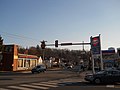 Roslyn. Corner of Easton (center-left side) and Bradfield (right side) Rds.
 -
 Roslyn Fire Company.
 -

-
 Roslyn Park.
 -
 Bridge over Sandy Run in Roslyn Park.
 -
 Faith Community Church.
 -
 Roslyn Presbyterian Church.
 -
 Roslyn Elementary School.
 -
 Roslyn VFW Post.


References
- ^ "Roslyn". Geographic Names Information System. United States Geological Survey, United States Department of the Interior.
- ^ a b "A Brief History of Roslyn Valley". Greater Glenside Chamber of Commerce website. Archived from the original on June 24, 2008. Retrieved August 23, 2008.
{{cite web}}: External link in|work= - ^ * Interstate Commerce Commission (1931). "Interstate Commerce Commission Reports: Decisions of the Interstate Commerce Commission of the United States. Valuation reports". U.S. Government Printing Office. p. 680.
- ^ "SEPTA Roslyn Station". SEPTA website. Archived from the original on August 29, 2008. Retrieved August 23, 2008.
- ^ "Township Information: Communities (Roslyn)". Abington Township website. Retrieved October 26, 2010.
{{cite web}}: External link in|work= - ^ https://data.census.gov/all?q=Roslyn%20CDP,%20Pennsylvania
