
Pilar, Paraguay
Pilar | |
|---|---|
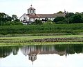
Clockwise from the top: The city view of Pilar, the Local government of Pilar, Cabildo of Pilar, Downtown Pilar and the Pilar umbrellas at the city center | |
 Flag | |
 Pilar | |
| Coordinates: 26°52′12″S 58°18′0″W / 26.87000°S 58.30000°W | |
| Country | |
| Department | Ñeembucú |
| Foundation | October 12, 1779 |
| Government | |
| • Intendente Municipal | Carlos Francisco Silva Medina. |
| Area | |
| • Total | 1,130 km2 (440 sq mi) |
| Population (2019) | |
| • Total | 32,810 |
| • Density | 29/km2 (75/sq mi) |
| Time zone | UTC-04 (AST) |
| • Summer (DST) | UTC-03 (ADT) |
| Postal code | 2800 |
| Area code | +595 (786) |


Pilar (Spanish pronunciation: [piˈlaɾ]) is the capital city of the Paraguayan department of Ñeembucú, located along the Paraguay River in the southwestern part of the country. Located about 258 km (160 mi) from Asunción, Pilar serves as an important center of commerce and government for the far southwestern region of the country.
History
Pilar was founded by Pedro Melo de Portugal on October 12, 1779. The original name of the settlement was Villa del Ñeembucú, named for the nearby Arroyo Ñeembucú that flows into the Paraguay River. Four years later it was renamed Villa del Pilar by Spanish priest Marcial Antonio Uliambre, for the Basilica of Our Lady of the Pillar (Spanish: Catedral-Basílica de Nuestra Señora del Pilar) in his hometown of Zaragoza.
Demographics
Pilar has a total population of 32,810, with 14,298 men and 15,030 women, according to information provided by the General Directorate of Statistics, Polls and Census.[1]
Tourism
The center of the city is home to a large number of historical buildings dating back to the founding of the city.
The Basilica of Our Lady of Pilar, whose feast day is celebrated on October 12, is a magnificent church constructed by Italian missionaries to the city.
During Semana Santa the city is the site of a large fishing tournament and competition that attracts participants and spectators from all over Paraguay and Northern Argentina.
The city's location on the Rio Paraguay provides a prime location for boating and fishing. There are walking paths, pavilions, and parks located on the shores of the river. The shores of the calmer Arroyo Ñeembucú provide the city's residents with a beach to enjoy on hot December days.
The Town Council Museum was constructed in 1817, during the government of President Gaspar Rodríguez de Francia. It is excellently preserved. This is the only build of this nature that is still preserved in the country. The museum contains objects of historical importance including photographs, trophies and medals that belonged to the Marshall López, as well as pieces of columns from the old church, weapons, bullets, ammunitions, chains, lances, shields and other historical artifacts.
A very popular tourist destination is also the "Fiesta Hawaiana" Party every January 2. In recent years, this party which is held alongside the Neembucu River has reached about 20,000 to 30,000 people coming from all parts of Paraguay, Argentina and Uruguay
Pilar is considered as one of the safest and cleanest cities in all of Paraguay.
Transportation
.jpg)
Pilar is served by Carlos Miguel Jiménez Airport, however traffic is limited to private airplanes.
Located at the very Argentina–Paraguay border, the ferry traffic from the harbor of Pilar connects the city to Puerto Cano, which is close to Resistencia and Formosa in Argentina. There is a paved highway, the Route 4, that is 140 km long and starts at San Ignacio.
Until quite recently, there was no paved route to Asunción, and the city was nearly isolated during periods of rain. Today, however, there is the Villeta–Alberdi–Pilar Route that connects the capital with Pilar, and daily buses use it to go to various other cities. The primary mode of transportation to other cities is by bus from the Central Terminal, which offers routes to Asunción and its suburbs such as Luque, Ñemby, and San Lorenzo, as well as Ciudad del Este, Villarrica, Pedro Juan Caballero, Encarnación, Santa Rita, Humaitá, Concepción, Mariscal Estigarribia and Villa Hayes.
Within the city, motorcycles and mopeds make up the bulk of traffic, with bicycles also constituting a significant percentage of traffic. In addition, it is quite possible to find people on horseback, in horse-drawn carts, on foot, and in cars or trucks on the same street.
Climate
Situated near the confluence of the Paraguay and Paraná rivers, Pilar is in a region of the country with many small streams, rivers and wetlands that contribute to a humid climate. The average annual temperature is 22 °C (72 °F). Summer temperatures can reach as high as 40 °C (104 °F), and it winter it drops to as low as −3 °C (27 °F). The rainy months are January, March, April and October; the dryer are May and August. The Köppen Climate Classification subtype for this climate is "Cfa" (Humid Subtropical Climate).[2]
| Climate data for Pilar (1991-2020) | |||||||||||||
|---|---|---|---|---|---|---|---|---|---|---|---|---|---|
| Month | Jan | Feb | Mar | Apr | May | Jun | Jul | Aug | Sep | Oct | Nov | Dec | Year |
| Record high °C (°F) | 42.4 (108.3) |
40.5 (104.9) |
39.6 (103.3) |
36.5 (97.7) |
33.7 (92.7) |
31.8 (89.2) |
33.2 (91.8) |
34.9 (94.8) |
38.0 (100.4) |
39.6 (103.3) |
40.4 (104.7) |
41.6 (106.9) |
42.4 (108.3) |
| Mean daily maximum °C (°F) | 33.4 (92.1) |
32.4 (90.3) |
31.1 (88.0) |
28.0 (82.4) |
24.1 (75.4) |
22.3 (72.1) |
22.0 (71.6) |
24.5 (76.1) |
26.4 (79.5) |
28.7 (83.7) |
30.2 (86.4) |
32.5 (90.5) |
28.0 (82.4) |
| Daily mean °C (°F) | 27.1 (80.8) |
26.2 (79.2) |
24.8 (76.6) |
21.9 (71.4) |
18.2 (64.8) |
16.5 (61.7) |
15.5 (59.9) |
17.3 (63.1) |
19.3 (66.7) |
22.3 (72.1) |
24.0 (75.2) |
26.2 (79.2) |
21.6 (70.9) |
| Mean daily minimum °C (°F) | 22.2 (72.0) |
21.8 (71.2) |
20.2 (68.4) |
17.5 (63.5) |
14.0 (57.2) |
12.2 (54.0) |
10.6 (51.1) |
11.9 (53.4) |
13.8 (56.8) |
17.4 (63.3) |
18.8 (65.8) |
21.1 (70.0) |
16.8 (62.2) |
| Record low °C (°F) | 14.5 (58.1) |
12.1 (53.8) |
8.5 (47.3) |
7.7 (45.9) |
4.0 (39.2) |
1.0 (33.8) |
0.7 (33.3) |
1.0 (33.8) |
3.6 (38.5) |
7.4 (45.3) |
9.8 (49.6) |
9.8 (49.6) |
0.7 (33.3) |
| Average precipitation mm (inches) | 173.5 (6.83) |
131.8 (5.19) |
144.1 (5.67) |
172.2 (6.78) |
110.0 (4.33) |
62.3 (2.45) |
46.2 (1.82) |
37.1 (1.46) |
72.2 (2.84) |
187.3 (7.37) |
162.9 (6.41) |
159.2 (6.27) |
1,458.9 (57.44) |
| Average precipitation days (≥ 0.1 mm) | 9 | 8 | 9 | 8 | 6 | 6 | 5 | 6 | 7 | 9 | 9 | 8 | 90 |
| Average relative humidity (%) | 69 | 72 | 75 | 78 | 79 | 79 | 76 | 74 | 71 | 69 | 69 | 67 | 73 |
| Source: NOAA (extremes, precipitation days, humidity 1961-1990)[3][4][5] | |||||||||||||
-
 The Pilar Cathedral, Paraguay
 -
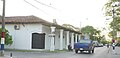
 Coastal Avenue, Pilar, Paraguay
 -
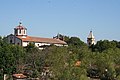 Nuestra Señora del Pilar Cathedral, Pilar, Paraguay
 -
 Pilar, Paraguay
 -
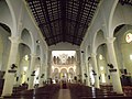 Interior of the Pilar Cathedral, Paraguay


.jpg)

..jpg)
Sister cities
Pilar has sister cities:
 Carmelo, Uruguay
 Reconquista, Argentina
Sources
- World Gazeteer: Paraguay[dead link] – World-Gazetteer.com
References
- ^ "Archived copy" (PDF). www.dgeec.gov.py. Archived from the original (PDF) on 16 October 2015. Retrieved 12 January 2022.
{{cite web}}: CS1 maint: archived copy as title (link) - ^ Climate Summary for Pilar, Paraguay
- ^ "Pilar Climate Normals 1961–1990". National Oceanic and Atmospheric Administration. Retrieved March 9, 2015.
- ^ "World Meteorological Organization Climate Normals for 1991–2020". World Meteorological Organization. Retrieved 2 August 2023.
- ^ "86255: Pilar (Paraguay)". ogimet.com. OGIMET. 17 January 2022. Retrieved 20 January 2022.
External links
| International | |
|---|---|
| National | |
| Geographic | |