
Haidao Township
Haidao Township
海岛乡 | |
|---|---|
 Haidao Township Location in the East China Sea  Haidao Township Haidao Township (Southeast Asia)  Haidao Township Haidao Township (Asia) | |
| Coordinates: 26°30′16″N 120°02′53″E / 26.504426°N 120.048166°E | |
| Country | People's Republic of China |
| Province | Fujian |
| Prefecture-level city | Ningde |
| County | Xiapu |
| Villages | 6 |
| Area | |
| • Total | 29.8 km2 (11.5 sq mi) |
| Population (2010)[2] | |
| • Total | 7,915 |
| • Density | 270/km2 (690/sq mi) |
| Time zone | UTC+8 (China Standard) |

Haidao Township (Chinese: 海岛乡[3]; pinyin: Hǎidǎo Xiāng; Wade–Giles: Hai3-tao3 Hsiang1; lit. 'township of the islands of the sea') is an insular township off the Asian mainland in Xiapu County, Ningde, Fujian, China (PRC).[4] The township is immediately north of present-day Lienchiang County (the Matsu Islands), ROC (Taiwan).[5]
History
On December 15, 1950, the Matsu Administrative Office (馬祖行政公署) of Fujian Province, Republic of China was established including modern-day Lienchiang County (the Matsu Islands), ROC (Taiwan) as well as islands in present-day Haidao Township including the Sishuang Islands (四礵), Xiyang (西洋), and Fuying (浮鷹) as well as Taishan (台山) in present-day Shacheng, Fuding.[6][7][8]: 460
On December 29, 1950, the Daxiyang Island was attacked by Chinese Communist forces and defended by guerrilla forces.[8]: 460
On July 27, 1951, ten motorized with over four hundred Chinese Communist soldiers attacked Xiyang Island. More than sixty guerrilla soldiers defending the island died. Xiyang District (西洋區) leader Li Kuei-Yu (李貴漁) and Sishuang District (四礵區) leader Wang Chen-Chi (王振基) died in a grenade attack. The attacking force retreated.[8]: 461 [9]
In early July 1953, Chinese Nationalist guerillas retreated from islands in the Xiyang Island (Chihchutao) area.[10] The area came under the control of Chinese Communists on July 13, 1953.[11][12]
On November 29, 1954, Haidao District (海岛区) was established.[2][11]
In 1958, Haidao Commune (海岛公社) was established.[2]
In 1984, Haidao Township (海岛乡) was established.[2]
In August 2012, the Haidao Township, Xiapu County Uninhabited Island Environmental Protection Volunteer Service Unit (霞浦县海岛乡无人岛屿环境保护志愿者服务队), forerunner of the Xiapu County Island Environmental Protection Organization (霞浦县岛屿环境保护协会), was established.[13]
In March 2016, a woman was murdered in Beishuang Village and two suspects were apprehended.[14]
From May 25 to 27, 2018, the 2018 Xiapu, China Ocean Fishing Competition was held in the Sishuang islands.[15]: 34
In late April 2019, representatives from the nearby Dongyin Township's government (ROC) visited Haidao Township.[16][17]
Geography
Islands in Haidao Township include:[1][2]
- Xiyang Island (西洋岛), also known as Spider Island[18][19][20] (Zhizhu Island, Chihchu Island,[20] Chih-chu Tao;[21] 蜘蛛島[22]) 26°30′36″N 120°02′43″E / 26.509879°N 120.045344°E
- Fuying Island (浮鹰岛), also known as Double Peak Island[19] (Shuangfeng Island; 雙峯島)[22] 26°34′42″N 120°08′26″E / 26.578459°N 120.140509°E
- the Sishuang Islands (Sishuang Liedao, Pei-shuang Lieh-tao;[22] 四礵列岛)
- Beishuang Island (Pei-shuang;[22] 北礵岛) 26°42′08″N 120°21′09″E / 26.702357°N 120.352581°E
- Dongshuang Island (Tung-shuang;[22] 东礵岛) 26°40′54″N 120°22′59″E / 26.681677°N 120.382951°E
- Xishuang Island (Hsi-shuang;[22] 西礵岛) 26°39′15″N 120°19′16″E / 26.654204°N 120.321156°E
- Nanshuang Island (Nan-shuang;[22] 南礵岛) 26°38′43″N 120°21′23″E / 26.645148°N 120.356295°E
- Xiaoxiyang Island (小西洋岛), also known as Isthmus Island (Yisimasi Island, I-ssu-ma-ssu Tao;[23] 乙四馬四島[22]) 26°32′47″N 120°00′04″E / 26.546441°N 120.001213°E
- Kuishan Island (Kuishan Dao; 魁山岛[24]), also known as Zhuishan (Chui Shan; 錐山[22]) 26°29′37″N 120°08′05″E / 26.493586°N 120.134632°E
- Maci Island (Ma Chick;[22] 马刺岛) 26°32′17″N 120°08′21″E / 26.538001°N 120.139128°E
- Nigu Island (Nu Geu Sen;[22] 尼姑屿)[25] 26°33′27″N 120°09′05″E / 26.557534°N 120.151459°E
- Wu Island (Inside Island;[26] 乌屿[11]: frontispiece ) 26°33′24″N 119°58′06″E / 26.556564°N 119.968421°E
- Ma'an Island (马鞍岛[11]: frontispiece ) 26°31′47″N 120°01′22″E / 26.529661°N 120.022837°E
- Dadong Island (大东屿[11]: frontispiece ) 26°30′07″N 119°58′59″E / 26.502041°N 119.983012°E
Liang Island in Beigan Township, Lienchiang County (the Matsu Islands), ROC (Taiwan) is 19.25 kilometers (11.96 mi) from Kuishan Island in the township.[5] The Sishuang islands are north-northwest of Dongyin Township, Lienchiang County (the Matsu Islands), ROC (Taiwan).[27][28]
Xiyang and Fuying Island are divided from mainland Asia by the Xiao'an Channel (Xiao'an Shuidao, Hsiao An Shui Tao; 小安水道).[22]
Administrative divisions
Haidao Township includes six villages centered on three of the islands:[2][11]: frontispiece
Xiyang Island:
Fuying Island:
Beishuang Island:
Demographics

| Year | Pop. | ±% p.a. |
|---|---|---|
| 2000 | 10,871 | — |
| 2010 | 7,915 | −3.12% |
| [2] | ||
Economy
Most of the residents are involved in fishing-related work.[29]
Gallery
-
 Map including some islands in the western part of present-day Haidao Township (AMS, 1954)
 -
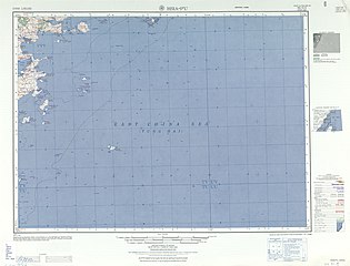 Map including most of present-day Haidao Township (AMS, 1953)
 -
 Map including present-day Haidao Township area (AMS, 1954)
 -
 Map including present-day Haidao Township area (DMA, 1972)
 -
 Map including present-day Haidao Township area (DMA, compiled 1971, revised 1996)
 -
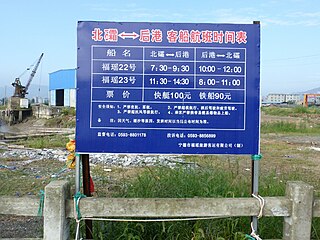 Beishuang (北礵) - Hougang (后港) ferry schedule
 -
 Ferry
Ferry


See also
References
- ^ a b 世行贷款福建渔港建设项目(北礵二级渔 港工程)海洋环境影响报告书 (报批本) (PDF) (in Simplified Chinese). Fujian Environmental Science Academy 福建省环境科学研究院. p. 46.
海岛乡由西洋、浮鹰、四礵列岛、小西洋、魁山、马刺等43 个岛屿组成,海域面积广阔,海岸线总长度为 104.5km,浅海和滩涂面积 15.6 万亩,陆地 总面积 29.8km2。
- ^ a b c d e f g h 海岛乡 [Haidao Township]. XZQH.org (in Simplified Chinese). 22 December 2015. Archived from the original on 15 September 2016. Retrieved 21 February 2020.
由西洋岛、浮鹰岛、四礵列岛等43个大小岛屿组成。面积29.8平方千米。常住人口7915人(2010年六普)。辖6个行政村。{...}1954年设海岛区,1958年改公社,1984年改乡。1996年,面积29.8平方千米,{...}2000年常住人口10871人(五普)。
- ^ Haidao (Approved - N) at GEOnet Names Server, United States National Geospatial-Intelligence Agency
- ^ 2018年统计用区划代码和城乡划分代码:海岛乡 [2018 Statistical Area Numbers and Rural-Urban Area Numbers: Haidao Township] (in Simplified Chinese). National Bureau of Statistics of the People's Republic of China. 2018. Retrieved 21 February 2020.
统计用区划代码 城乡分类代码 名称 350921205201 210 宫东村委会 350921205202 210 宫西村委会 350921205203 210 烟台村委会 350921205204 220 北礵村委会 350921205205 220 里澳村委会 350921205206 220 文澳村委会
- ^ a b 藍鴻安 (1 February 2010). 空軍防校專科班14期藍鴻安:亮島慨述 [Air Force Academy Special Class Lan Hung-an, No. 14: A Brief Introduction to Liang Island] (in Chinese (Taiwan)). Tainan. Retrieved 28 August 2019.
西距北竿、東距東引均為二萬六千公尺,北距大陸福建省霞埔縣僅帶水之隔,距離最近之魁山島為一萬九千二百五十公尺。
- ^ 林金炎 (24 June 2011). 馬祖紀事-1950 /林金炎 [Chronicle of Matsu-1950/Lin Chin-yen] (in Chinese (Taiwan)). Retrieved 21 February 2020.
12月15日、福建省政府成立「馬祖行政公署」,行政區以島為單位,改設馬祖為八區,即「南竿」、「北竿」、「白肯」、「東湧」、「四礵」、「岱山(台山)」、「西洋」、「浮鷹」區,
- ^ 請問:連江縣政府的沿革 [Question: The Evolution of Lienchiang County Government]. 馬祖資訊網 (in Chinese (Taiwan)). 25 June 2008. Retrieved 22 February 2020.
鄉政沿革
39年12月15日,「馬祖行政公署」成立於南竿,將原設之區署及鄉公所撤銷,行政區域改以島為單位,改設南竿、北竿、白肯、東湧、四霜、西洋、浮鷹、岱山等8區,各區設區公所,區下設村、伍,為地方基層行政組織。 - ^ a b c 林金炎, ed. (2006). 莒光鄉志 [The Biography of Jyuguang Township] (in Chinese (Taiwan)). ISBN 986-00-5026-0.
- ^ 共軍機帆船10餘艘,載運約400餘人,再次進犯西洋島,我游擊隊60餘人及西洋區長李貴漁、四霜區長王振基,全部壯烈犧牲,但共軍旋即撤離。大陸(連江縣志)記載:人民解放軍八十四師二五一團第二次解放西洋、浮鷹兩島,不久再次退出。. Taiwan Memory (in Chinese (Taiwan)). Archived from the original on 8 October 2020. Retrieved 7 October 2020.
- ^ "Chinese Communist Treatment of Coastal Islanders, Fukien". CIA. 16 September 1953. pp. 1–2. Retrieved 21 February 2020 – via Internet Archive.
[Sanitized] Comment. The Chinese Nationalist guerrillas withdrew from islands in the Chihchutao area in early July [sanitized] and are now concentrated on Yinshan (N 26-22, E 120-30). Chihchutao, Shuangfengtao, Machick, and Chuishan are now Chinese Communist controlled although not occupied by troops. The Nationalists have lost control over these islands and it is extremely difficult for them to return to the area.
- ^ a b c d e f 福建省霞浦县地方志编纂委员会, ed. (1999). 霞浦县志 [Xiapu County Annals] (in Simplified Chinese). Beijing: 方志出版社. pp. 1, 34. ISBN 7-80122-542-2.
乌屿{...}马鞍岛{...}大东屿
{...}
7月13日,人民解放军解放台湾当局控制的西洋、浮鹰、北礵等岛屿,解放军某部分驻各岛。
{...}
1954年
{...}
11月29日,海岛区公所在三沙成立。次年1月,福鼎县大、小嵛山等岛屿划归海岛区管辖。 - ^ 馬祖歲月印記. p. 079.
- ^ 海岛乡召开霞浦县岛屿环境保护协会成立大会. 闽东青年网 -- 共青团宁德市委员会主办 (in Simplified Chinese). 7 September 2017. Retrieved 23 February 2020.
据悉,霞浦县岛屿环境保护协会前身为霞浦县海岛乡无人岛屿环境保护志愿者服务队,成立于2012年8月,
- ^ 潘奕燃, ed. (17 March 2016). 福建霞浦两男子抢劫杀害一女子 并抛尸入海 [Two Men in Xiapu, Fujian Rob and Kill a Woman and then Throw the Body in the Sea] (in Simplified Chinese). Archived from the original on 29 March 2016. Retrieved 22 February 2020.
- ^ 王泽红 (5 June 2018). 2018中国霞浦休闲海钓大赛成功举办 [2018 Leisure Sea Fishing Competition in Xiapu, China Held Successfully]. All China Federation of Supply and Marketing Cooperatives (in Simplified Chinese). Retrieved 22 February 2020.
5月25日~27日,2018中国霞浦休闲海钓大赛在福建省霞浦县的四礵列岛隆重举行
- ^ 台湾马祖东引乡公所、东引乡民代表会来霞参访考察 [Taiwan Matsu Dongyin Township Office and Dongyin Township Congressional Representative Visit Xiapu]. 霞浦县人民政府 (in Simplified Chinese). 29 April 2019. Retrieved 22 February 2020.
- ^ 馬祖日報2019/05/01影音/恭逢其盛 東引團福建霞浦富足天后宮媽祖誕辰 [Matsu Daily May 1, 2019 Video/Audio Special Occasion Dongyin Group Visits Xiapu, Fujian's Tian Hou Temple for the Birth of Mazu] (in Chinese (Taiwan)). Matsu Daily. 1 May 2019. Retrieved 22 February 2020 – via YouTube.
- ^ Spider Island (Variant - V) at GEOnet Names Server, United States National Geospatial-Intelligence Agency
- ^ a b Sailing directions to accompany seven charts of the coast of China, between Amoy bay, and the Yángtsz' kiáng. Vol. 12. Canton: The Chinese Repository. 1843. p. 412-3 – via Internet Archive.
Spider island is a large island, with two remarkable cones on its northern end, called Double Peak island; it is 3 1/2 miles long, and its highest peak 1190 feet high.
- ^ a b "CURRENT INTELLIGENCE BULLETIN". Office of Current Intelligence, CIA. 5 May 1955. p. 9. Retrieved 27 August 2019.
CHIHCHU ISLAND
(SPIDER ISLAND) - ^ Chih-chu Tao (Variant - V) at GEOnet Names Server, United States National Geospatial-Intelligence Agency
- ^ a b c d e f g h i j k l "NG 51-5 HSIA-P'U" (in English and Chinese). Washington, D. C.: Army Map Service. 1953 – via Perry–Castañeda Library Map Collection.
Pei-shuang 北霜{...}Tung-shuang 東霜{...}PEI-SHUANG LIEH-TAO 北霜列島{...}Hsi-shuang{...}Nan-shuang (122) 南霜{...}HSIAO AN SHUI TAO 小安水道{...}SHUANG-FENG TAO 雙峯島{...}Nu Geu Sen{...}I-ssu-ma-ssu Tao (Isthmus Island)乙四馬四島{...}Ma Chick{...}CHIH-CHU-TAO 蜘蛛島{...}Nu Geu Sen{...}Chui Shan 錐山
- ^ I-ssu-ma-ssu-tao (Variant - V) at GEOnet Names Server, United States National Geospatial-Intelligence Agency
- ^ Kuishan Dao (Approved - N) at GEOnet Names Server, United States National Geospatial-Intelligence Agency
- ^ 叶朝玉, ed. (3 June 2018). 清新海岛 (in Simplified Chinese). 宁德网消息. Retrieved 22 February 2020.
5月16日,我们来到霞浦县西洋岛拍日出。日光下,西洋岛对面的浮鹰岛、马刺岛、尼姑屿显得格外美丽。
- ^ Wikimedia photo
- ^ 福建霞浦四礵列島漸成兩岸海釣愛好者新寵 [The Sishuang Islands of Fujian's Xiapu are Becoming the New Love of Sea Fishing Enthusiasts on both sides of the Taiwan Strait] (in Traditional Chinese). Sina News. 29 May 2009. Retrieved 21 February 2020.
四礵列島位於福建省霞浦縣海島鄉,與馬祖東西引相望,由東礵、南礵、西礵、北礵等島嶼組成。
- ^ 「旅遊天下」走進福建霞浦四礵海島,感受「地球第四極」之美 ["Travel the World"- Visit the Sishuang Islands in Fujian's Xiapu and Experience the Beauty of the "Four Extremes of the Earth"] (in Traditional Chinese). 12 June 2018. Retrieved 21 February 2020.
其中北礵島面積1.88平方公里,人口2800多,地理位置最為顯要,正處福建省閩東漁場中部,靠近東引島,扼閩浙海上交通之要道,島上不但有駐軍觀察所,而且國家海洋站和上海導航局都在北礵島設點觀測海紋和氣候情況。
- ^ 霞浦县海岛乡:无“微”不至的计生服务 [Haidao Township, Xiapu County: "We"ticulous Family Planning Service on WeChat] (in Simplified Chinese). 宁德网. 22 July 2016. Retrieved 22 February 2020.
海岛乡四面环海,地理位置特殊,总人口12668人,大多数村民从事海上养殖捕捞业。
External links
- 霞浦千里海疆行27之《海岛人家》 ('People of the Sea Part 27: Visit to Xiapu's Thousand-li Coastal Frontier') ((in Chinese))