
Search results
There is a page named "File:Texas 110.svg" on Wikipedia
 24 in by 24 in (600 mm by 600 mm) Texas State Highway shield, made to the specifications of the sign detail. Uses the Roadgeek 2005 fonts. (United States...(384 × 384 (7 KB)) - 22:56, 13 February 2024
 English 1935 specification Texas State Highway shield...(1,600 × 1,600 (20 KB)) - 17:18, 12 July 2024
 English 1917 specification Texas State Highway shield...(1,600 × 1,600 (17 KB)) - 19:13, 11 June 2024
 DescriptionTexas Loop 110.svg 24 in by 24 in (600 mm by 600 mm) Texas State Highway shield, made to the specifications of the sign detail. Uses the Roadgeek...(384 × 384 (11 KB)) - 21:10, 2 April 2022
 DescriptionTexas Spur 110.svg 24 in by 24 in (600 mm by 600 mm) Texas State Highway shield, made to the specifications of the sign detail. Uses the Roadgeek...(384 × 384 (13 KB)) - 23:17, 1 April 2022
 DescriptionTexas FM 110.svg 24 in by 24 in (600 mm by 600 mm) Texas State Highway shield, made to the specifications of the sign detail. Uses the Roadgeek...(600 × 600 (9 KB)) - 23:26, 20 April 2022
 DescriptionTexas 110 map.svg Map of Texas State Highway 110 Source Own work Author 25or6to4...(870 × 516 (383 KB)) - 22:25, 13 February 2024
 Geographische Begrenzung der Karte: * N: 37.2° N * S: 33.4° File:USA Texas location map.svg licensed with Cc-by-3.0, GFDL 2009-06-17T20:30:36Z Alexrk2 1500x1484...(13,310 × 6,935 (10.66 MB)) - 21:23, 14 August 2024
 Geographische Begrenzung der Karte: * N: 37.2° N * S: 33.4° USA Texas location map.svg licensed with Cc-by-3.0, GFDL 2009-06-17T20:30:36Z Alexrk2 1500x1484...(13,310 × 6,935 (9.24 MB)) - 21:23, 14 August 2024
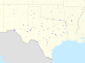 Geographische Begrenzung der Karte: * N: 37.2° N * S: 33.4° File:USA Texas location map.svg licensed with Cc-by-3.0, GFDL 2009-06-17T20:30:36Z Alexrk2 1500x1484...(4,602 × 3,455 (1.08 MB)) - 06:35, 13 June 2024
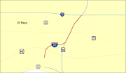 DescriptionInterstate 110 map (Texas).svg This file has no description, and may be lacking other information. Please provide a meaningful description...(1,180 × 688 (80 KB)) - 17:37, 16 September 2020
 N-S-Streckung 110 %. Geographische Begrenzung der Karte: * N: 33.3° N * S: 14.2° N * W: 118.5° W * O: 86.3° W {{en|Locat File:USA_Alaska_location_map.svg licensed...(4,858 × 2,531 (2.25 MB)) - 16:15, 12 June 2024
 Geographische Begrenzung der Karte: * N: 37.2° N * S: 33.4° File:USA Texas location map.svg licensed with Cc-by-3.0, GFDL 2009-06-17T20:30:36Z Alexrk2 1500x1484...(4,818 × 2,510 (1.5 MB)) - 11:44, 26 June 2021
 Texas at Austin http://www.lib.utexas.edu/maps/middle_east_and_asia/kurdish_lands_92.jpg Underlying map (from the commons): Syria location map2.svg I...(725 × 600 (30 KB)) - 21:27, 14 September 2023
 Geographische Begrenzung der Karte: * N: 37.2° N * S: 33.4° File:USA Texas location map.svg licensed with Cc-by-3.0, GFDL 2009-06-17T20:30:36Z Alexrk2 1500x1484...(6,927 × 3,609 (2.3 MB)) - 15:04, 1 October 2020
 Geographische Begrenzung der Karte: * N: 37.2° N * S: 33.4° File:USA Texas location map.svg licensed with Cc-by-3.0, GFDL 2009-06-17T20:30:36Z Alexrk2 1500x1484...(4,818 × 2,510 (1.56 MB)) - 04:58, 15 November 2022
 Geographische Begrenzung der Karte: * N: 37.2° N * S: 33.4° File:USA Texas location map.svg licensed with Cc-by-3.0, GFDL 2009-06-17T20:30:36Z Alexrk2 1500x1484...(4,898 × 2,552 (1.45 MB)) - 07:06, 26 October 2020
 Geographische Begrenzung der Karte: * N: 37.2° N * S: 33.4° File:USA Texas location map.svg licensed with Cc-by-3.0, GFDL 2009-06-17T20:30:36Z Alexrk2 1500x1484...(4,818 × 2,510 (1.59 MB)) - 13:10, 14 October 2020
 N-S-Streckung 110 %. Geographische Begrenzung der Karte: * N: 33.3° N * S: 14.2° N * W: 118.5° W * O: 86.3° W {{en|Locat File:USA Alaska location map.svg licensed...(4,858 × 2,531 (2.18 MB)) - 09:21, 30 October 2020
 This image is a derivative work of the following images: File:Blank_US_Map.svg licensed with GFDL 2008-10-09T16:36:40Z Howcheng 959x593 (80121 Bytes) Reverted...(959 × 593 (202 KB)) - 14:57, 24 January 2022


.svg)


