
File:Second world war asia 1937-1942 map en6.png
Size of this preview: 780 × 600 pixels. Other resolutions: 312 × 240 pixels | 624 × 480 pixels | 999 × 768 pixels | 1,298 × 998 pixels.
Original file (1,298 × 998 pixels, file size: 250 KB, MIME type: image/png)
| This is a file from the Wikimedia Commons. Information from its description page there is shown below. Commons is a freely licensed media file repository. You can help. |
Summary
| Description |
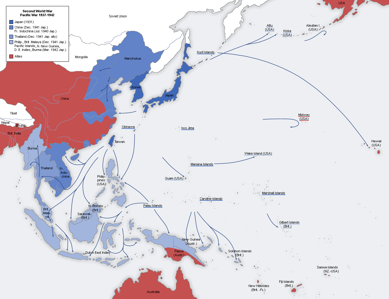
English: A map of the Japanese advance from 1937 to 1942. 日本語: 日本による占領地域の拡大(1937年から1942年) |
| Date |
Original Image: 22 August 2005 Derivative Image: 31 July 2011 |
| Source |
This file was derived from: Second world war asia 1937-1942 map de.png |
| Author |
Original Author: User:San Jose Derivative Author: Dead Mary |
| Permission (Reusing this file) |
This image is a translation of the original, created and released under the terms of the GNU Free Documentation License. |
Licensing

|
Permission is granted to copy, distribute and/or modify this document under the terms of the GNU Free Documentation License, Version 1.2 or any later version published by the Free Software Foundation; with no Invariant Sections, no Front-Cover Texts, and no Back-Cover Texts. A copy of the license is included in the section entitled GNU Free Documentation License. |
| This file is licensed under the Creative Commons Attribution-Share Alike 3.0 Unported license. | ||
| ||
| This licensing tag was added to this file as part of the GFDL licensing update. |
File history
Click on a date/time to view the file as it appeared at that time.
| Date/Time | Thumbnail | Dimensions | User | Comment | |
|---|---|---|---|---|---|
| current | 19:55, 13 February 2022 | | 1,298 × 998 (250 KB) | Rzzgn | second_world_war_asia_1937-1942_map.png |
| 14:57, 17 April 2021 |  | 1,298 × 998 (250 KB) | Rzzgn | Although Manchuria was a puppet state, it was never a part of the Japanese Empire. | |
| 18:59, 14 July 2020 |  | 1,298 × 998 (197 KB) | FDRMRZUSA | Reverted to version as of 20:16, 6 May 2017 (UTC): Manchukuo was part of the Japanese empire before 1936. | |
| 07:47, 8 January 2019 |  | 1,298 × 998 (250 KB) | Rzzgn | the colour of Manchukuo | |
| 20:16, 6 May 2017 |  | 1,298 × 998 (197 KB) | Dr.Koo | Reverted to version as of 22:01, 11 July 2014 (UTC) use the same color scheme as in other language versions. | |
| 20:15, 6 May 2017 |  | 1,298 × 998 (219 KB) | Dr.Koo | Reverted to version as of 22:01, 11 July 2014 (UTC) use the same color scheme as in other language versions. | |
| 17:26, 18 July 2014 |  | 1,298 × 998 (220 KB) | Hohum | More natural colours - water blue, etc. | |
| 22:01, 11 July 2014 |  | 1,298 × 998 (219 KB) | Renamed user df2u53fvwn | Tibet didn't officially independent | |
| 22:59, 30 July 2011 |  | 1,298 × 998 (197 KB) | Dead Mary |
File usage
The following pages on the English Wikipedia use this file (pages on other projects are not listed):
- Arakan campaign (1942–1943)
- Burma campaign (1942–1943)
- Empire of Japan
- Foreign policy of the Franklin D. Roosevelt administration
- Japan during World War II
- Kantokuen
- Key events of the 20th century
- Military history of Japan
- Mont Tremblant Conference
- Nanshin-ron
- Presidency of Franklin D. Roosevelt, third and fourth terms
- Shōwa era
- World War II
- Talk:Japan/Archive 19
- User:Hmmmmm maybe/sandbox
- User:JacksonKo/ideology
- User:Paul Siebert/sandbox
- User:Shafin10555/sandbox
- Draft:World War II (Draft)
Global file usage
The following other wikis use this file:
- Usage on azb.wikipedia.org
- Usage on bg.wikipedia.org
- Usage on br.wikipedia.org
- Usage on es.wikipedia.org
- Usage on fa.wikipedia.org
- Usage on fi.wikipedia.org
- Usage on fo.wikipedia.org
- Usage on fr.wikipedia.org
- Usage on gl.wikipedia.org
- Usage on he.wikipedia.org
- Usage on hy.wikipedia.org
- Usage on id.wikipedia.org
- Usage on it.wikipedia.org
- Usage on ja.wikipedia.org
- Usage on ja.wikibooks.org
- Usage on ka.wikipedia.org
- Usage on km.wikipedia.org
- Usage on ko.wikipedia.org
- Usage on lv.wikipedia.org
- Usage on mk.wikipedia.org
- Usage on ms.wikipedia.org
- Usage on nl.wikipedia.org
- Usage on pnb.wikipedia.org
- Usage on pt.wikipedia.org
- Usage on ro.wikipedia.org
- Usage on ru.wikipedia.org
- Usage on ta.wikipedia.org
- Usage on uk.wikipedia.org
- Usage on ur.wikipedia.org
- Usage on vi.wikipedia.org
- Usage on www.wikidata.org
- Usage on zh.wikipedia.org