
File:Quebec-Windsor Corridor.svg

Size of this PNG preview of this SVG file: 500 × 400 pixels. Other resolutions: 300 × 240 pixels | 600 × 480 pixels | 960 × 768 pixels | 1,280 × 1,024 pixels | 2,560 × 2,048 pixels.
Original file (SVG file, nominally 500 × 400 pixels, file size: 59 KB)
| This is a file from the Wikimedia Commons. Information from its description page there is shown below. Commons is a freely licensed media file repository. You can help. |
| Description |
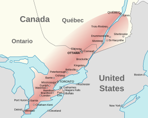
English: A map highlighting the
Français : Une carte de |
| Date | (UTC) |
| Source | |
| Author |
|
I, the copyright holder of this work, hereby publish it under the following licenses:
This file is licensed under the Creative Commons Attribution-Share Alike 2.5 Generic, 2.0 Generic and 1.0 Generic license.
- You are free:
- to share – to copy, distribute and transmit the work
- to remix – to adapt the work
- Under the following conditions:
- attribution – You must give appropriate credit, provide a link to the license, and indicate if changes were made. You may do so in any reasonable manner, but not in any way that suggests the licensor endorses you or your use.
- share alike – If you remix, transform, or build upon the material, you must distribute your contributions under the same or compatible license as the original.
| This file is licensed under the Creative Commons Attribution-Share Alike 3.0 Unported license. | ||
| ||
| This licensing tag was added to this file as part of the GFDL licensing update. |

|
Permission is granted to copy, distribute and/or modify this document under the terms of the GNU Free Documentation License, Version 1.2 or any later version published by the Free Software Foundation; with no Invariant Sections, no Front-Cover Texts, and no Back-Cover Texts. A copy of the license is included in the section entitled GNU Free Documentation License. |
You may select the license of your choice.
Original upload log
This image is a derivative work of the following images:
- File:Carte_administrative_du_Canada.svg licensed with Cc-by-sa-2.5,2.0,1.0, Cc-by-sa-3.0-migrated, GFDL
- 2008-03-23T04:49:21Z Yug 1280x1128 (239183 Bytes) The previous version put a difference between America (orange) and European territories. This one not : all out-Canada territories are orange.
- 2007-02-07T01:14:07Z Sting 1280x1128 (239260 Bytes) New upload : deleted bitmap background image
- 2007-02-07T01:08:37Z Sting 1280x1128 (133022 Bytes) Display problem correction test
- 2007-02-07T00:10:02Z STyx 1280x1128 (171544 Bytes) {{Created with Inkscape}} {{Information |Description= *{{fr}} Version SVG calquée sur [[:Image:Carte administrative du Canada.png]]. Chaque province est découpée indépendamment. *{{en}} Basic map of Canada. SVG version fr
Uploaded with derivativeFX
File history
Click on a date/time to view the file as it appeared at that time.
| Date/Time | Thumbnail | Dimensions | User | Comment | |
|---|---|---|---|---|---|
| current | 04:08, 24 July 2010 | | 500 × 400 (59 KB) | Vidioman | {{Information |Description=*{{en}} A map highlighting the en:Quebec City – Windsor Corridor *{{fr}} Une carte de fr:Corridor Québec-Windsor |Source=*File:Carte_administrative_du_Canada.svg |Date=2010-07-24 04:08 (UTC) |Author=*[[:File:Car |
File usage
The following pages on the English Wikipedia use this file (pages on other projects are not listed):
Global file usage
The following other wikis use this file:
- Usage on af.wikipedia.org
- Usage on ar.wikipedia.org
- Usage on be.wikipedia.org
- Usage on ca.wikipedia.org
- Usage on ckb.wikipedia.org
- Usage on da.wikipedia.org
- Usage on el.wikipedia.org
- Usage on eo.wikipedia.org
- Usage on es.wikipedia.org
- Usage on fa.wikipedia.org
- Usage on fi.wikipedia.org
- Usage on fr.wikipedia.org
- Usage on it.wikipedia.org
- Usage on ko.wikipedia.org
- Usage on pt.wikipedia.org
- Usage on ru.wikipedia.org
- Usage on sk.wikipedia.org
- Usage on sr.wikipedia.org
- Usage on te.wikipedia.org
- Usage on tr.wikipedia.org
- Usage on vi.wikipedia.org
- Usage on www.wikidata.org
- Usage on zh.wikipedia.org