
File:Nouvelle-France map-en.svg

Size of this PNG preview of this SVG file: 800 × 570 pixels. Other resolutions: 320 × 228 pixels | 640 × 456 pixels | 1,024 × 730 pixels | 1,280 × 912 pixels | 2,560 × 1,824 pixels | 1,530 × 1,090 pixels.
Original file (SVG file, nominally 1,530 × 1,090 pixels, file size: 586 KB)
| This is a file from the Wikimedia Commons. Information from its description page there is shown below. Commons is a freely licensed media file repository. You can help. |
Summary
| Description |
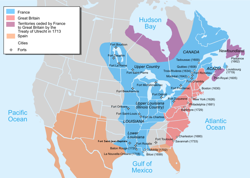
Català: Mapa de la Nova França sobre 1754-1755 English: Map of New France about 1750 using modern political boundaries Español: Mapa de la Nueva Francia cerca de 1750. Français : Carte de la Nouvelle-France vers 1754-1755 Norsk nynorsk: Kart over Ny Frankrike (ca 1754-1755) Русский: Карта Французских колоний в Америке 1750 中文(中国大陆): 1750年左右的新法兰西地图,附现代边界。 العربية : خريطة فرنسا الجديدة حوالي عام 1750 باستخدام الحدود السياسية الحديثة |
||
| Date | |||
| Source |
Own work using:
|
||
| Author | Pinpin | ||
| Other versions |
[]
|


|
This SVG file contains embedded text that can be translated into your language, using any capable SVG editor, text editor or the SVG Translate tool. For more information see: About translating SVG files. |
This W3C-unspecified vector image was created with Inkscape .
Licensing
I, the copyright holder of this work, hereby publish it under the following licenses:

|
Permission is granted to copy, distribute and/or modify this document under the terms of the GNU Free Documentation License, Version 1.2 or any later version published by the Free Software Foundation; with no Invariant Sections, no Front-Cover Texts, and no Back-Cover Texts. A copy of the license is included in the section entitled GNU Free Documentation License. |
This file is licensed under the Creative Commons Attribution-Share Alike 3.0 Unported, 2.5 Generic, 2.0 Generic and 1.0 Generic license.
- You are free:
- to share – to copy, distribute and transmit the work
- to remix – to adapt the work
- Under the following conditions:
- attribution – You must give appropriate credit, provide a link to the license, and indicate if changes were made. You may do so in any reasonable manner, but not in any way that suggests the licensor endorses you or your use.
- share alike – If you remix, transform, or build upon the material, you must distribute your contributions under the same or compatible license as the original.
You may select the license of your choice.
File history
Click on a date/time to view the file as it appeared at that time.
| Date/Time | Thumbnail | Dimensions | User | Comment | |
|---|---|---|---|---|---|
| current | 22:23, 27 December 2022 | | 1,530 × 1,090 (586 KB) | Tcr25 | remove stray circle from Saskatchewan |
| 16:09, 14 December 2022 |  | 1,530 × 1,090 (586 KB) | Tcr25 | plain SVG instead of Inkscape | |
| 13:24, 21 September 2021 |  | 1,530 × 1,090 (590 KB) | Tcr25 | Placed Fort Rosalie in proper location; added Fort St. Jean Baptiste (Natchitoches) | |
| 14:11, 10 October 2013 |  | 1,530 × 1,090 (550 KB) | Begoon | Reverted to version as of 14:02, 10 October 2013 | |
| 14:08, 10 October 2013 |  | 1,530 × 1,090 (265 KB) | Begoon | revert to compare rsvg render | |
| 14:02, 10 October 2013 |  | 1,530 × 1,090 (550 KB) | Begoon | revert for now - I'll play some more... | |
| 13:58, 10 October 2013 |  | 1,530 × 1,090 (265 KB) | Begoon | tweak a couple of label positions | |
| 13:53, 10 October 2013 |  | 1,530 × 1,090 (265 KB) | Begoon | actually - something spooky about this file ever since gradient was changed. I'm reverting to version with gradient, because it's consistent with other maps in series. Subsequent change to Fort Toulouse replicated, Mexico landmass added, layers fixed. | |
| 13:10, 10 October 2013 |  | 1,530 × 1,090 (550 KB) | Begoon | cities layer is wrong - try again | |
| 11:35, 10 October 2013 |  | 1,530 × 1,090 (633 KB) | Begoon | fix layers after addition |
File usage
The following pages on the English Wikipedia use this file (pages on other projects are not listed):
- Canada
- Canada–United States relations
- Colonial history of the United States
- European colonization of the Americas
- Former colonies and territories in Canada
- France–Americas relations
- Franco-Indian alliance
- French Americans
- French Louisianians
- French and Indian War
- French immigration to Puerto Rico
- Great Britain in the Seven Years' War
- History of Louisiana
- History of Michigan
- History of Pennsylvania
- History of St. Louis
- History of the United States
- Louis XV
- Louisiana
- Louisiana (New France)
- Louisiana Creole people
- Military history of Canada
- Mississippi River
- New France
- North American fur trade
- Northern Michigan
- Outline of United States history
- Peace of Utrecht
- Queen Anne's War
- Seven Years' War
- Spanish Texas
- United States
- Voyageurs
- Talk:Ming dynasty/Archive 2
- Talk:New France/Archive 1
- Talk:United States/Archive 93
- User:CactusJack/USA
- User:Kayoty/sandbox
- Wikipedia:Graphics Lab/Map workshop/Archive/Dec 2013
- Wikipedia:Graphics Lab/Map workshop/Archive/Jan 2011
- Portal:Canada/Selected picture
- Portal:Louisiana
- Portal:Michigan
- Portal:Pennsylvania
Global file usage
The following other wikis use this file:
- Usage on af.wikipedia.org
- Usage on an.wikipedia.org
- Usage on ar.wikipedia.org
- Usage on arz.wikipedia.org
- Usage on azb.wikipedia.org
- Usage on az.wikipedia.org
- Usage on bg.wikipedia.org
- Usage on bn.wikipedia.org
- Usage on cs.wikipedia.org
- Usage on cy.wikipedia.org
- Usage on da.wikipedia.org
- Usage on en.wikibooks.org
- Usage on es.wikipedia.org
- Usage on et.wikipedia.org
- Usage on eu.wikipedia.org
- Usage on fa.wikipedia.org
- Usage on fi.wikipedia.org
- Usage on fr.wikipedia.org
- Usage on he.wikipedia.org
- Usage on hu.wikipedia.org
- Usage on hy.wikipedia.org
- Usage on ia.wikipedia.org
- Usage on io.wikipedia.org
- Usage on it.wikipedia.org
- Usage on ja.wikipedia.org
View more global usage of this file.