
File:North Korean missile range.svg

Size of this PNG preview of this SVG file: 512 × 512 pixels. Other resolutions: 240 × 240 pixels | 480 × 480 pixels | 768 × 768 pixels | 1,024 × 1,024 pixels | 2,048 × 2,048 pixels.
Original file (SVG file, nominally 512 × 512 pixels, file size: 163 KB)
| This is a file from the Wikimedia Commons. Information from its description page there is shown below. Commons is a freely licensed media file repository. You can help. |
Summary
| Description |
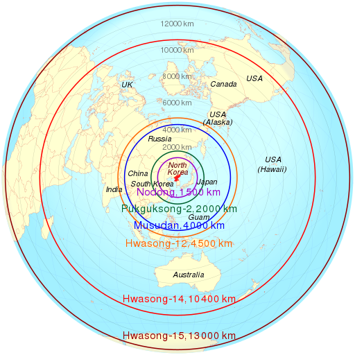
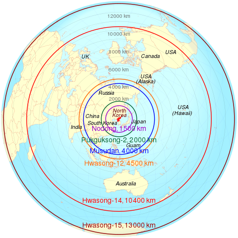
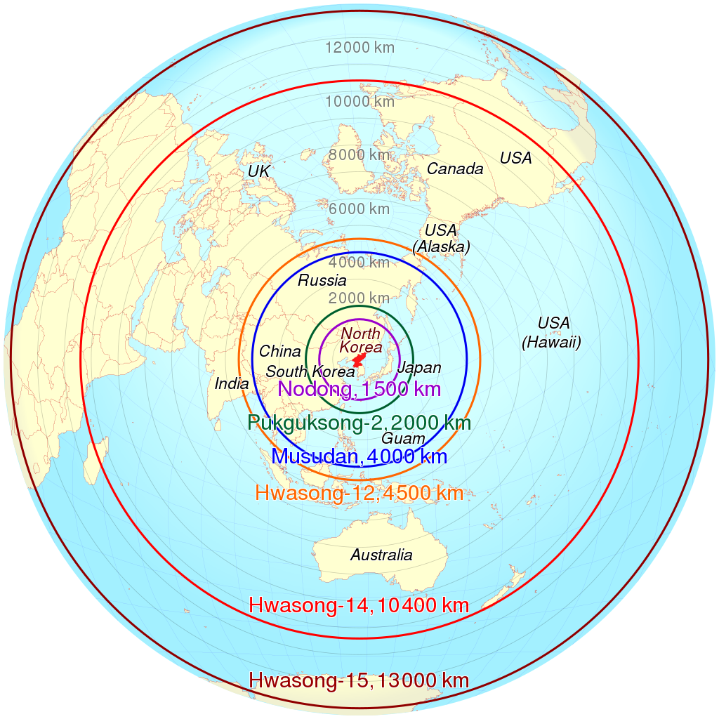
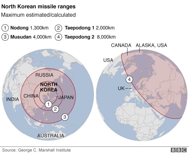
English: Azimuthal equidistant projection of estimated maximum range of some North Korean missiles based on data from http://ichef.bbci.co.uk/news/624/cpsprodpb/26F5/production/_88837990_north_korea_missile_ranges2_map624new.png . Deutsch: Geschätzte Reichweite nordkoreanischer Raketen auf Basis der folgenden Daten http://ichef.bbci.co.uk/news/624/cpsprodpb/26F5/production/_88837990_north_korea_missile_ranges2_map624new.png . |
||
| Date | |||
| Source | Own work based on: North-korean-missile-ranges.svg by TUBS | ||
| Author | Cmglee | ||
| SVG development | This map was created with an unknown SVG tool.
|
convert_absolute_to_relative_svg_path.py
| Python2 source |
|---|
#!/usr/bin/env python
PATH_OUT = 'out.txt'
PATHD    = "..."
import re
pathds     = re.findall(r'[A-Z][^A-Za-z]+', '%s ' % (PATHD))
outs       = []
x_previous = None
y_previous = None
for (i_pathd, pathd) in enumerate(pathds):
 fields = (re.sub(r'([A-Z]+)', r'\1\t', re.sub(r'[\s,]+', '\t', pathd)).
           split('\t'))
 # print(fields)
 command = fields[0]
 if (fields[1] == '' or fields[2] == ''): ## "Z"
  outs.append(command)
 else:
  x = round(float(fields[1]))
  y = round(float(fields[2]))
  if (i_pathd == 0): ## first point
   outs.append('%s%d,%d' % (command, x, y))
  else:
   x_out   = x - x_previous
   y_out   = y - y_previous
   command = command.lower()
   if (command != 'l' or (x_out != 0 and y_out != 0)):
    outs.append('%s%d,%d' % (command, x_out, y_out))
   else:
    if   (x_out != 0): outs.append('h%d' % (x_out))
    elif (y_out != 0): outs.append('v%d' % (y_out))
    else:              pass ## same point after rounding
  x_previous = x
  y_previous = y
print(len(outs))
f_out = open(PATH_OUT, 'wt')
f_out.write(''.join(outs))
f_out.close()
|
Licensing
I, the copyright holder of this work, hereby publish it under the following licenses:
This file is licensed under the Creative Commons Attribution-Share Alike 3.0 Unported license.
- You are free:
- to share – to copy, distribute and transmit the work
- to remix – to adapt the work
- Under the following conditions:
- attribution – You must give appropriate credit, provide a link to the license, and indicate if changes were made. You may do so in any reasonable manner, but not in any way that suggests the licensor endorses you or your use.
- share alike – If you remix, transform, or build upon the material, you must distribute your contributions under the same or compatible license as the original.

|
Permission is granted to copy, distribute and/or modify this document under the terms of the GNU Free Documentation License, Version 1.2 or any later version published by the Free Software Foundation; with no Invariant Sections, no Front-Cover Texts, and no Back-Cover Texts. A copy of the license is included in the section entitled GNU Free Documentation License. |
You may select the license of your choice.
Original upload log
This image is a derivative work of the following images:
- North Korea on the globe (Japan centered).svg licensed with Cc-by-sa-3.0, GFDL
- 2011-04-27T07:27:57Z TUBS 1246x1246 (1188392 Bytes)
.svg)
Uploaded with derivativeFX
File history
Click on a date/time to view the file as it appeared at that time.
| Date/Time | Thumbnail | Dimensions | User | Comment | |
|---|---|---|---|---|---|
| current | 08:14, 3 February 2022 | | 512 × 512 (163 KB) | Cmglee | Update as per http://bbc.com/news/world-asia-60193714#Advances-in-N-Koreas-missile-technology |
| 17:25, 5 July 2017 |  | 512 × 512 (163 KB) | Cmglee | Update Hwasong/KN-14 range. | |
| 18:01, 19 May 2017 |  | 512 × 512 (162 KB) | Cmglee | Add KN-08 and KN-14 from http://bbc.com/news/world-asia-17399847 | |
| 06:12, 11 May 2017 |  | 512 × 512 (162 KB) | Cmglee | Update ranges and map to azimuthal equidistant projection. | |
| 18:26, 4 April 2013 |  | 512 × 512 (688 KB) | Cmglee | Label Koreas. | |
| 12:52, 4 April 2013 |  | 512 × 512 (688 KB) | Cmglee | Add Guam and Hawaii. | |
| 12:28, 4 April 2013 |  | 512 × 512 (688 KB) | Cmglee | == {{int:filedesc}} == {{Information |Description={{de|Lage von XY (siehe Dateiname) auf der Erde.}} {{en|Location of XY (see filename) on the globe.}} |Source={{Derived from|North_Korea_on_the_globe_(Japan_centered).svg|disp... |
File usage
The following pages on the English Wikipedia use this file (pages on other projects are not listed):
- 2013 in North Korea
- 2018 Hawaii false missile alert
- Aegis system equipped vessels (ASEV)
- Azimuthal equidistant projection
- Hwasong-10
- Hwasong-12
- Hwasong-7
- Korean People's Army Strategic Force
- North Korea and weapons of mass destruction
- User:Cmglee
- User:Cmglee/svg
- Wikipedia:Miscellany for deletion/User:B3430715/Userboxes/privacy
Global file usage
The following other wikis use this file:
- Usage on ar.wikipedia.org
- Usage on ast.wikipedia.org
- Usage on bg.wikipedia.org
- Usage on ca.wikipedia.org
- Usage on de.wikipedia.org
- Usage on en.wikiquote.org
- Usage on es.wikipedia.org
- Usage on es.wikinews.org
- Usage on fa.wikipedia.org
- Usage on fi.wikipedia.org
- Usage on fr.wikipedia.org
- Usage on it.wikipedia.org
- Usage on ja.wikipedia.org
- Usage on ko.wikipedia.org
- Usage on nl.wikipedia.org
- Usage on no.wikipedia.org
- Usage on pl.wikipedia.org
- Usage on pt.wikipedia.org
- Usage on ru.wikipedia.org
- Usage on ru.wikinews.org
- Usage on sr.wikipedia.org
- Usage on sv.wikipedia.org
- Usage on tr.wikipedia.org
- Usage on uk.wikipedia.org
- Usage on vi.wikipedia.org
- Usage on www.wikidata.org
- Usage on zh.wikipedia.org
View more global usage of this file.