
File:Miletus Bay silting evolution map-en.svg

Size of this PNG preview of this SVG file: 800 × 581 pixels. Other resolutions: 320 × 232 pixels | 640 × 465 pixels | 1,024 × 744 pixels | 1,280 × 930 pixels | 2,560 × 1,860 pixels | 1,857 × 1,349 pixels.
Original file (SVG file, nominally 1,857 × 1,349 pixels, file size: 1.54 MB)
| This is a file from the Wikimedia Commons. Information from its description page there is shown below. Commons is a freely licensed media file repository. You can help. |
Summary
| Camera location | | View this and other nearby images on: OpenStreetMap |
|---|
| Description |
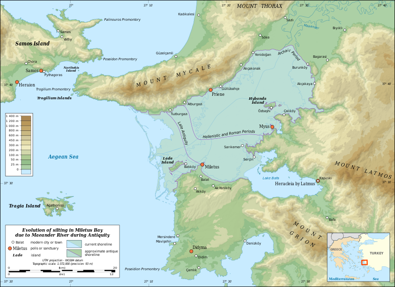
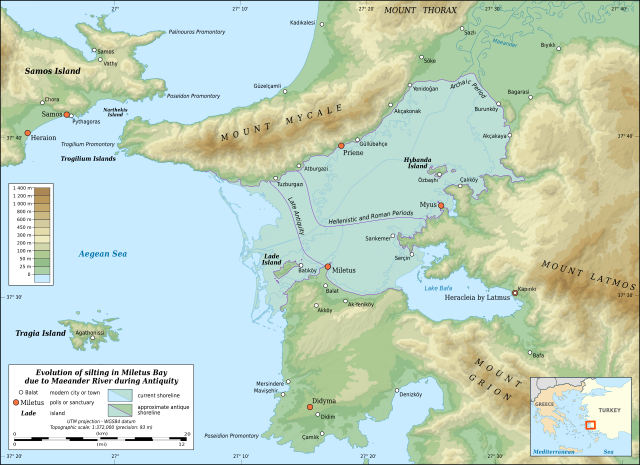
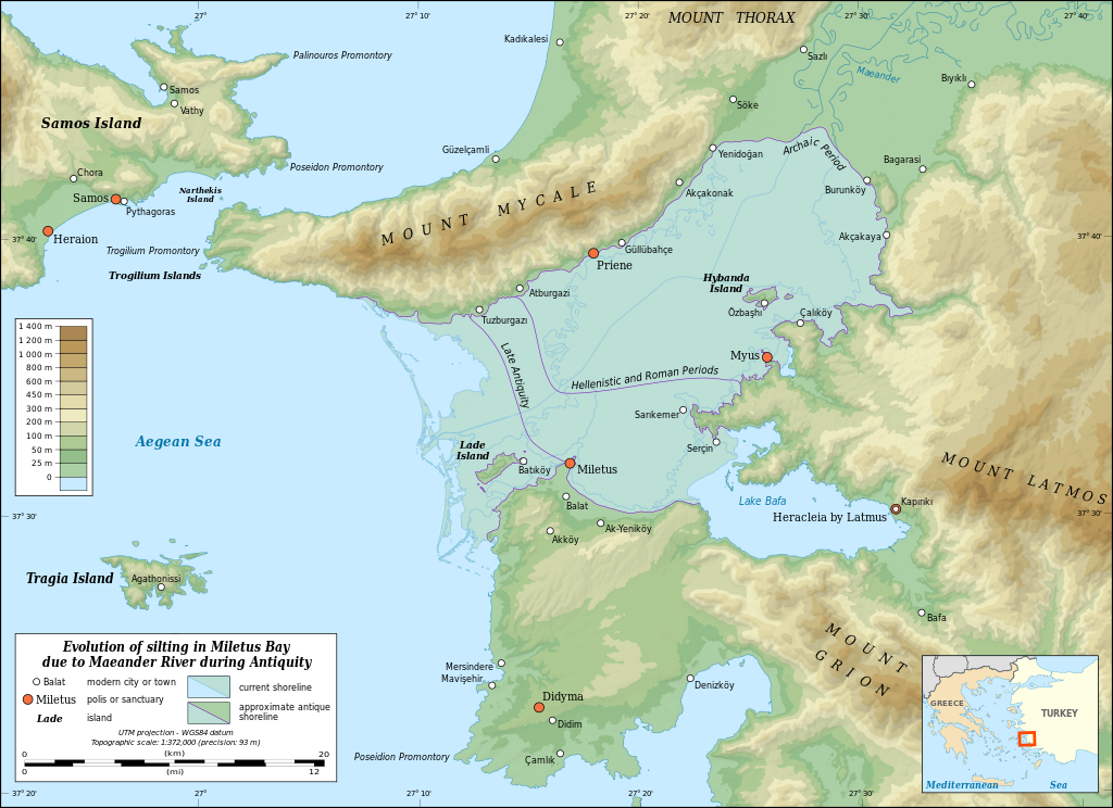
English: Map in English showing the silting evolution of Miletus Bay due to the alluvium brought by the Maeander River during Antiquity. Are also displayed some of the modern cities and towns of the area, the current course of the Maeander River and the current shoreline.
Notes:
Français : Carte en anglais de l'évolution de l'ensablement de la baie de Milet dû aux alluvions déposés par le Méandre. Sont aussi montrés le parcours actuel du Méandre, le littoral actuel et diverses agglomérations modernes. Notes :
UTM projection – WGS84 datum |
||
| Date | |||
| Source |
Own work
|
||
| Author | Eric Gaba (Sting - fr:Sting) | ||
| Permission (Reusing this file) |
|
||
| Other versions |
|


|
This SVG file contains embedded text that can be translated into your language, using any capable SVG editor, text editor or the SVG Translate tool. For more information see: About translating SVG files. |
Licensing
Eric Gaba, Wikimedia Commons user Sting, the copyright holder of this work, hereby publishes it under the following licenses:

|
Permission is granted to copy, distribute and/or modify this document under the terms of the GNU Free Documentation License, Version 1.2 or any later version published by the Free Software Foundation; with no Invariant Sections, no Front-Cover Texts, and no Back-Cover Texts. A copy of the license is included in the section entitled GNU Free Documentation License. |
This file is licensed under the Creative Commons Attribution-Share Alike 3.0 Unported license.
Attribution: Eric Gaba, Wikimedia Commons user Sting
- You are free:
- to share – to copy, distribute and transmit the work
- to remix – to adapt the work
- Under the following conditions:
- attribution – You must give appropriate credit, provide a link to the license, and indicate if changes were made. You may do so in any reasonable manner, but not in any way that suggests the licensor endorses you or your use.
- share alike – If you remix, transform, or build upon the material, you must distribute your contributions under the same or compatible license as the original.
You may select the license of your choice.
File history
Click on a date/time to view the file as it appeared at that time.
| Date/Time | Thumbnail | Dimensions | User | Comment | |
|---|---|---|---|---|---|
| current | 21:00, 16 July 2010 | | 1,857 × 1,349 (1.54 MB) | Sting | Test: embedded sRGB profile |
| 12:22, 2 July 2009 |  | 1,857 × 1,349 (1.59 MB) | Sting | == Summary == {{Location|37|35|00|N|27|16|00|E|scale:500000}} <br/> {{Information| |Description={{en|Map in English showing the silting evolution of Miletus Bay due to the alluvium brought by the [[:en:Büyük Menderes River|Maeander Rive |
File usage
The following pages on the English Wikipedia use this file (pages on other projects are not listed):
- Battle of Lade (201 BCE)
- Battle of Mycale
- Beşparmak Mountains
- Büyük Menderes River
- Didyma
- Dilek Peninsula-Büyük Menderes Delta National Park
- Lake Bafa
- Lydian–Milesian War
- Miletus
- Mycale
- Myus
- Priene
- User:Abyssal/bla
- Wikipedia:Featured picture candidates/Miletus Bay Silting Map
- Wikipedia:Featured picture candidates/October-2016
Global file usage
The following other wikis use this file:
- Usage on ar.wikipedia.org
- Usage on azb.wikipedia.org
- Usage on az.wikipedia.org
- Usage on bg.wikipedia.org
- Usage on ca.wikipedia.org
- Usage on ceb.wikipedia.org
- Usage on cs.wikipedia.org
- Usage on de.wikipedia.org
- Usage on de.wikivoyage.org
- Usage on el.wikipedia.org
- Usage on es.wikipedia.org
- Usage on fa.wikipedia.org
- Usage on fi.wikipedia.org
- Usage on fr.wikipedia.org
- Usage on he.wikipedia.org
- Usage on hr.wikipedia.org
- Usage on hu.wikipedia.org
- Usage on hy.wikipedia.org
- Usage on id.wikipedia.org
- Usage on it.wikipedia.org
- Usage on ja.wikipedia.org
- Usage on ka.wikipedia.org
View more global usage of this file.