
File:Map Europe alliances 1914-en.svg

Size of this PNG preview of this SVG file: 800 × 473 pixels. Other resolutions: 320 × 189 pixels | 640 × 379 pixels | 1,024 × 606 pixels | 1,280 × 758 pixels | 2,560 × 1,515 pixels | 1,002 × 593 pixels.
Original file (SVG file, nominally 1,002 × 593 pixels, file size: 97 KB)
| This is a file from the Wikimedia Commons. Information from its description page there is shown below. Commons is a freely licensed media file repository. You can help. |
| Description |
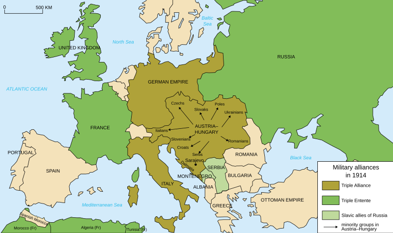
Deutsch: Karte von Militärbündnisse in Europa in 1914, (Englisch) English: Map of military alliances of Europe in 1914. (English) Français : Carte des alliances militaires en Europe en 1914. (Anglais) Русский: Схема военных альянсов в Европе в 1914 г. (англ.) |
| Date |
|
| Source | Translated in English from French SVG Map_Europe_alliances_1914-fr.svg |
| Author |
|
| Other versions |
Derivative works of this file: Map Europe alliances 1914-he.svg
[] .gif)
|


W3C-validity not checked.

|
This SVG file contains embedded text that can be translated into your language, using any capable SVG editor, text editor or the SVG Translate tool. For more information see: About translating SVG files. |
| This is a retouched picture, which means that it has been digitally altered from its original version. Modifications: English translation. The original can be viewed here: Map Europe alliances 1914-fr.svg:
|
I, the copyright holder of this work, hereby publish it under the following license:
This file is licensed under the Creative Commons Attribution-Share Alike 2.5 Generic, 2.0 Generic and 1.0 Generic license.
- You are free:
- to share – to copy, distribute and transmit the work
- to remix – to adapt the work
- Under the following conditions:
- attribution – You must give appropriate credit, provide a link to the license, and indicate if changes were made. You may do so in any reasonable manner, but not in any way that suggests the licensor endorses you or your use.
- share alike – If you remix, transform, or build upon the material, you must distribute your contributions under the same or compatible license as the original.
Original upload log
This image is a derivative work of the following images:
- File:Map_Europe_alliances_1914-fr.svg licensed with Cc-by-sa-2.5,2.0,1.0, Cc-by-sa-2.5,2.0,1.0/en
- 2007-02-26T23:36:35Z Bibi Saint-Pol 998x593 (100171 Bytes) {{Information |Description= {{fr|Carte des alliances militaires en Europe en 1914.}} |Source=Création personnelle(version renommée de [[:Image:Les rivalités en Europe en 1914.svg]]) |Date=2006-10-31 |Author=[[User:Histori
Uploaded with derivativeFX
File history
Click on a date/time to view the file as it appeared at that time.
| Date/Time | Thumbnail | Dimensions | User | Comment | |
|---|---|---|---|---|---|
| current | 20:59, 4 April 2021 | | 1,002 × 593 (97 KB) | Andrewtips | File uploaded using svgtranslate tool (https://svgtranslate.toolforge.org/). Added translation for zh-hant. |
| 21:02, 4 August 2020 |  | 1,002 × 593 (92 KB) | Ionaki | File uploaded using svgtranslate tool (https://svgtranslate.toolforge.org/). Added translation for eu. | |
| 21:02, 4 August 2020 |  | 1,002 × 593 (92 KB) | Ionaki | File uploaded using svgtranslate tool (https://svgtranslate.toolforge.org/). Added translation for eu. | |
| 20:59, 4 August 2020 |  | 1,002 × 593 (92 KB) | Ionaki | File uploaded using svgtranslate tool (https://svgtranslate.toolforge.org/). Added translation for eu. | |
| 15:14, 2 August 2020 |  | 1,002 × 593 (72 KB) | Bogomolov.PL | reservoirs on Dnieper, Don and Volga rivers were built after Second WW, erased. Romania, Serbia, Montenegro, Albania and Bulgaria borders corrected | |
| 11:22, 21 January 2017 |  | 1,002 × 593 (75 KB) | Perey | This portrays the Triple Alliance, not the Central Powers (of which Italy was never one). Error introduced in version dated 2010-03-07 by Mnmazur (talk). | |
| 21:18, 28 November 2015 |  | 1,002 × 593 (75 KB) | Turnless | Aland Islands | |
| 12:25, 2 January 2015 |  | 1,002 × 593 (75 KB) | Borodun | Moonsund archipelago is territory of Russia | |
| 00:30, 2 January 2015 |  | 1,002 × 593 (70 KB) | ZYjacklin | Capitalize the name for Romania. | |
| 16:49, 17 November 2010 |  | 1,002 × 593 (70 KB) | Ras67 | "cropped" and minor things |
File usage
The following pages on the English Wikipedia use this file (pages on other projects are not listed):
- 1914
- European balance of power
- France–Russia relations
- Franz Joseph I of Austria
- Friedrich von Pourtalès
- History of Western civilization
- Military alliance
- Polish Legions in World War I
- Sweden during World War I
- Switzerland during the World Wars
- Treaty of London (1915)
- Triple Alliance (1882)
- Triple Entente
- Two-front war
- World War I
- Yugoslav Committee
- Talk:World War I/Archive 16
- User:Chickstarr404/Gather lists
- User:Chickstarr404/Gather lists/16060 – "Paris 1919" by Margaret Macmillan
- User:Falcaorib
- Wikipedia:Graphics Lab/Illustration workshop/Archive/Nov 2010
- Draft:Participants of World War I
Global file usage
The following other wikis use this file:
- Usage on ar.wikipedia.org
- Usage on bcl.wikipedia.org
- Usage on bh.wikipedia.org
- Usage on br.wikipedia.org
- Usage on cy.wikipedia.org
- Usage on da.wikipedia.org
- Usage on el.wikipedia.org
- Usage on en.wikibooks.org
- Usage on en.wiktionary.org
- Usage on et.wikipedia.org
- Usage on eu.wikipedia.org
- Usage on fa.wikipedia.org
- Usage on fiu-vro.wikipedia.org
- Usage on fi.wikipedia.org
- Usage on fi.wikibooks.org
- Usage on fo.wikipedia.org
- Usage on fy.wikipedia.org
- Usage on id.wikipedia.org
- Usage on incubator.wikimedia.org
- Usage on io.wikipedia.org
- Usage on ja.wikipedia.org
- Usage on ka.wikipedia.org
- Usage on ku.wikipedia.org
- Usage on lfn.wikipedia.org
- Usage on ml.wikipedia.org
- Usage on ms.wikipedia.org
- Usage on myv.wikipedia.org
- Usage on pa.wikipedia.org
- Usage on pl.wikipedia.org
- Usage on pnb.wikipedia.org
View more global usage of this file.