
File:List of dignitaries at the state funeral of Elizabeth II on a map.png

Size of this preview: 800 × 369 pixels. Other resolutions: 320 × 148 pixels | 640 × 295 pixels | 1,024 × 472 pixels | 1,280 × 591 pixels | 2,560 × 1,181 pixels | 7,192 × 3,318 pixels.
Original file (7,192 × 3,318 pixels, file size: 1.51 MB, MIME type: image/png)
| This is a file from the Wikimedia Commons. Information from its description page there is shown below. Commons is a freely licensed media file repository. You can help. |
Summary

|
File:Countries at the state funeral of Elizabeth II.svg is a vector version of this file. It should be used in place of this PNG file when not inferior.
File:List of dignitaries at the state funeral of Elizabeth II on a map.png → File:Countries at the state funeral of Elizabeth II.svg
For more information, see Help:SVG. |
 |
| Description |
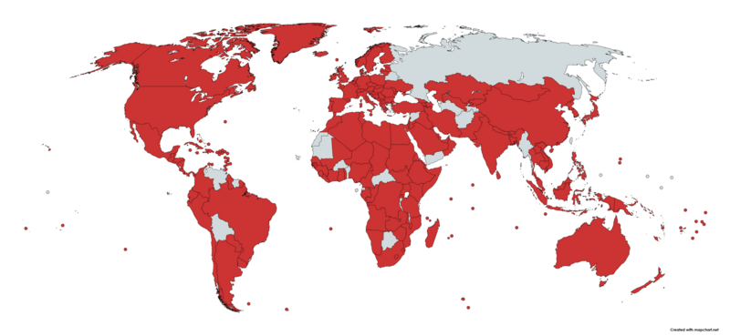
English: Map showing the countries in which at least one representative attended the funeral of Queen Elizabeth II of the United Kingdom. They included royal houses, presidents, heads of state, ministers, spouses of presidents or heads of state, representatives of supranational organizations, ambassadors, high commissioners, general secretaries, and governors. |
| Date | |
| Source | map chart |
| Author | me |
Licensing
| This map was created for free at MapChart.net. All maps created there are licensed under the Creative Commons Attribution-ShareAlike 4.0 International License. See the "Licensing" link on the home page, or the MapChart.net feedback page for the image license info, and this MapChart.net Commons discussion. Use {{Mapchart.net}} to provide attribution for maps created with that service.
See also: Other maps on Commons created with Mapchart.net: Category:Mapchart.net and this search query; other map and chart resources. |
I, the copyright holder of this work, hereby publish it under the following license:
This file is licensed under the Creative Commons Attribution-Share Alike 4.0 International license.
- You are free:
- to share – to copy, distribute and transmit the work
- to remix – to adapt the work
- Under the following conditions:
- attribution – You must give appropriate credit, provide a link to the license, and indicate if changes were made. You may do so in any reasonable manner, but not in any way that suggests the licensor endorses you or your use.
- share alike – If you remix, transform, or build upon the material, you must distribute your contributions under the same or compatible license as the original.
File history
Click on a date/time to view the file as it appeared at that time.
| Date/Time | Thumbnail | Dimensions | User | Comment | |
|---|---|---|---|---|---|
| current | 22:05, 5 June 2023 | | 7,192 × 3,318 (1.51 MB) | Mr. Lechkar | Added Iran, North Korea, Nicaragua via digital alteration of original file |
| 12:13, 26 September 2022 |  | 7,192 × 3,318 (1.35 MB) | Anotherwikipedianuser | + Vanuatu. | |
| 20:28, 22 September 2022 |  | 7,192 × 3,318 (1.35 MB) | Anotherwikipedianuser | Falkland and South Georgia... | |
| 18:17, 22 September 2022 |  | 7,192 × 3,318 (1.35 MB) | Anotherwikipedianuser | Square again... | |
| 18:15, 22 September 2022 |  | 7,192 × 3,318 (1.75 MB) | Anotherwikipedianuser | Saint Pierre and Miquelon. | |
| 18:13, 22 September 2022 |  | 7,192 × 3,318 (1.35 MB) | Anotherwikipedianuser | That square... | |
| 18:11, 22 September 2022 |  | 7,192 × 3,318 (1.75 MB) | Anotherwikipedianuser | Solomon Islands was missing. | |
| 10:20, 20 September 2022 |  | 7,192 × 3,318 (1.55 MB) | Anotherwikipedianuser | Updated with Iraq. | |
| 20:07, 19 September 2022 |  | 7,192 × 3,318 (1.35 MB) | Anotherwikipedianuser | Another small fix. | |
| 19:56, 19 September 2022 |  | 7,192 × 3,318 (1.35 MB) | Anotherwikipedianuser | Better quality and small fix. |
File usage
No pages on the English Wikipedia use this file (pages on other projects are not listed).
Global file usage
The following other wikis use this file:
- Usage on ca.wikipedia.org
- Usage on fr.wikinews.org
- Usage on he.wikipedia.org
- Usage on hu.wikipedia.org
- Usage on ja.wikipedia.org
- Usage on pl.wikipedia.org
- Usage on pt.wikipedia.org
- Usage on zh.wikipedia.org