
File:Italy Liguria location map.svg

Size of this PNG preview of this SVG file: 704 × 357 pixels. Other resolutions: 320 × 162 pixels | 640 × 325 pixels | 1,024 × 519 pixels | 1,280 × 649 pixels | 2,560 × 1,298 pixels.
Original file (SVG file, nominally 704 × 357 pixels, file size: 222 KB)
| This is a file from the Wikimedia Commons. Information from its description page there is shown below. Commons is a freely licensed media file repository. You can help. |
Summary
| Description |
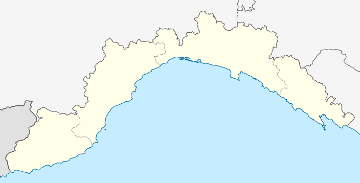
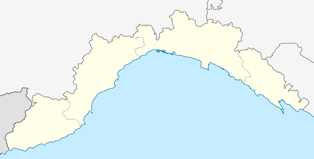
Deutsch: Positionskarte von Ligurien (Italien) English: Location map of Liguria region (Italy) Español: Mapa de localización de la Región de Liguria (Italia).
Equirectangular projection, N/S stretching 115 %. Geographic limits of the map:
|
| Date | |
| Source |
This file was derived from: Map of region of Liguria, Italy.svg |
| Author |
|
Licensing
I, the copyright holder of this work, hereby publish it under the following licenses:

|
Permission is granted to copy, distribute and/or modify this document under the terms of the GNU Free Documentation License, Version 1.2 or any later version published by the Free Software Foundation; with no Invariant Sections, no Front-Cover Texts, and no Back-Cover Texts. A copy of the license is included in the section entitled GNU Free Documentation License. |
This file is licensed under the Creative Commons Attribution-Share Alike 3.0 Unported license.
- You are free:
- to share – to copy, distribute and transmit the work
- to remix – to adapt the work
- Under the following conditions:
- attribution – You must give appropriate credit, provide a link to the license, and indicate if changes were made. You may do so in any reasonable manner, but not in any way that suggests the licensor endorses you or your use.
- share alike – If you remix, transform, or build upon the material, you must distribute your contributions under the same or compatible license as the original.
You may select the license of your choice.
File history
Click on a date/time to view the file as it appeared at that time.
| Date/Time | Thumbnail | Dimensions | User | Comment | |
|---|---|---|---|---|---|
| current | 11:32, 21 May 2013 | | 704 × 357 (222 KB) | Milenioscuro | thick lines |
| 02:35, 21 May 2013 |  | 704 × 357 (222 KB) | Milenioscuro | to match with other location maps of the category | |
| 02:27, 21 May 2013 |  | 704 × 357 (222 KB) | Milenioscuro | User created page with UploadWizard |
File usage
More than 100 pages use this file. The following list shows the first 100 pages that use this file only. A full list is available.
- Airole
- Alassio
- Albenga
- Albisola Superiore
- Albissola Marina
- Altare
- Andora
- Apricale
- Aquila d'Arroscia
- Arenzano
- Armo
- Arnasco
- Aurigo
- Badalucco
- Bajardo
- Balestrino
- Bardineto
- Bergeggi
- Boissano
- Bordighera
- Borghetto Santo Spirito
- Borghetto d'Arroscia
- Borgio Verezzi
- Borgomaro
- Bormida, Liguria
- Cairo Montenotte
- Camogli
- Camporosso
- Caravonica
- Castel Vittorio
- Castellaro
- Ceriana
- Cervo, Liguria
- Cesio
- Chiavari
- Chiusanico
- Chiusavecchia
- Cipressa
- Civezza
- Cosio di Arroscia
- Costarainera
- Deiva Marina
- Diano Arentino
- Diano Castello
- Diano Marina
- Diano San Pietro
- Dolceacqua
- Dolcedo
- Finale Ligure
- Genoa Cristoforo Colombo Airport
- Isolabona
- La Spezia
- Laigueglia
- Lavagna
- Leivi
- Lerici
- Lucinasco
- Mendatica
- Molini di Triora
- Montegrosso Pian Latte
- Monterosso al Mare
- Noli
- Olivetta San Michele
- Ospedaletti
- Perinaldo
- Pietrabruna
- Pieve di Teco
- Pigna, Liguria
- Pompeiana
- Pontedassio
- Pornassio
- Porto Venere
- Portofino
- Prelà
- Ranzo
- Rapallo
- Recco
- Rezzo
- Riomaggiore
- Riva Ligure
- Rocchetta Nervina
- San Bartolomeo al Mare
- San Biagio della Cima
- San Lorenzo al Mare
- Sanremo
- Santo Stefano al Mare
- Sarzana
- Savona
- Sestri Levante
- Soldano, Liguria
- Taggia
- Terzorio
- Triora
- Vado Ligure
- Vallebona
- Vallecrosia
- Vasia
- Ventimiglia
- Vernazza
- Vessalico
View more links to this file.
Global file usage
The following other wikis use this file:
- Usage on ar.wikipedia.org
- Usage on azb.wikipedia.org
- ویلا فارالدی
- ووبیا
- وندن
- ونتیمیقلیا
- تاجیا
- وسالیکو
- پیوه لیقوره
- پیوه دی تکو
- ورنزا
- کیاواری
- پینیونه
- پینیا
- کویلیانو
- وتسی پورتیو
- وتزانو لیقوره
- والهکروزیا
- پیترابرونا
- پیترا لیقوره
- پیانا کریکسیا
- کاسارتزا لیقوره
- آئوریقو
- پونتینورا
- پونتهداسیو
- کوقولتو
- کوقورنو
- والبونا
- والبروننا
- کوسریا
- کوستاراینرا
- واسیا
- وارسه لیقور
- کارودانو
- واراتزه
- وادو لیقوره
- کارو (کومونه)
- پومپیانا
- نیرونه
- کارکاره
- نه (لیقوریا)
- کورلیا لیقوره
- نولی
- پورناسیو
- کاراوونیکا
- پورتوفینو
- پورتو ونه ره
- ناسینو
- میولیا
- مینیانقو
- میلزیمو
View more global usage of this file.