
File:Illinois 1718.jpg

Size of this preview: 479 × 599 pixels. Other resolutions: 192 × 240 pixels | 589 × 737 pixels.
Original file (589 × 737 pixels, file size: 232 KB, MIME type: image/jpeg)
| This is a file from the Wikimedia Commons. Information from its description page there is shown below. Commons is a freely licensed media file repository. You can help. |
Summary
| Description |
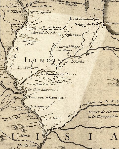
English: Illinois in 1718, approximate modern state area highlighted, from Carte de la Louisiane et du cours du Mississipi by Guillaume de L'Isle. This map shows Chicago as being the strategic point of connection between the Great Lakes and the Mississippi River Basin. |
|||||||||||||||||||||||
| Date | (rev. 2009) | |||||||||||||||||||||||
| Source |
|
|||||||||||||||||||||||
| Author |
|
|||||||||||||||||||||||
| Permission (Reusing this file) |
US Govt Public Domain, also author +100 years | |||||||||||||||||||||||

Licensing
|
This work is in the public domain in its country of origin and other countries and areas where the copyright term is the author's life plus 100 years or fewer. | |
| This file has been identified as being free of known restrictions under copyright law, including all related and neighboring rights. | |
Original upload log
The original description page was here. All following user names refer to en.wikipedia.
- 2009-07-25 15:17 Billwhittaker 589×737× (237103 bytes) {{Information |Description = Illinois in 1718, approximate modern state area highlighted, from ''Carte de la Louisiane et du cours du Mississipi'' by [[Guillaume de L'Isle]]. |Source = Library of Congress Public Domain Site: http://hdl.loc.go
File history
Click on a date/time to view the file as it appeared at that time.
| Date/Time | Thumbnail | Dimensions | User | Comment | |
|---|---|---|---|---|---|
| current | 19:42, 21 September 2009 | | 589 × 737 (232 KB) | Jeangagnon | {{Information |Description={{en|Illinois in 1718, approximate modern state area highlighted, from ''Carte de la Louisiane et du cours du Mississipi'' by en:Guillaume de L'Isle.}} |Source=Transferred from [http://en.wikipedia.org en.wikipedia]<br/> ( |
File usage
The following pages on the English Wikipedia use this file (pages on other projects are not listed):
Global file usage
The following other wikis use this file:
- Usage on ar.wikipedia.org
- Usage on arz.wikipedia.org
- Usage on bg.wikipedia.org
- Usage on en.wikibooks.org
- Usage on es.wikipedia.org
- Usage on he.wikipedia.org
- Usage on ja.wikipedia.org
- Usage on pt.wikipedia.org
- Usage on ru.wikipedia.org
- Usage on uk.wikipedia.org