
File:Grossgliederung Europas-en.svg

Size of this PNG preview of this SVG file: 577 × 599 pixels. Other resolutions: 231 × 240 pixels | 462 × 480 pixels | 740 × 768 pixels | 986 × 1,024 pixels | 1,973 × 2,048 pixels | 683 × 709 pixels.
Original file (SVG file, nominally 683 × 709 pixels, file size: 952 KB)
| This is a file from the Wikimedia Commons. Information from its description page there is shown below. Commons is a freely licensed media file repository. You can help. |
| Description |
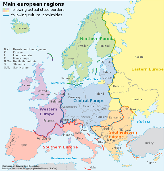
[] Aragonés: Rechions europeyas proposatas por Ständiger Ausschuss für geographische Namen (StAGN) Català: Regions europees proposades per Ständiger Ausschuss für geographische Namen (StAGN) Deutsch: Großgliederung Europas, Vorschlag des Ständigen Ausschuss für geographische Namen (StAGN) English: European regions as proposed by Ständiger Ausschuss für geographische Namen (StAGN) Español: Regiones europeas propuestas por Ständiger Ausschuss für geographische Namen (StAGN) Français : Carte des régions d'Europe, en allemand, selon le Ständigen Ausschuss für geographische Namen (StAGN) Hrvatski: Pregled europskih regija po kriterijima kulture i po državnim granicama Polski: Mapa regionów europejskich, w języku niemieckim, wg propozycjiStałego Komitetu ds. Nazw Geograficznych (StAGN) Македонски: Карта на регионите во Европа според ЕУ на македонски. Русский: Европейские регионы Українська: Європейські регіони на основі пропозиції Ständiger Ausschuss für geographische Namen (StAGN) 中文: 欧洲 العربية : خارطة مناطق ودُول أوروپَّا وفقًا لِمُؤسسة Ständiger Ausschuss für geographische Namen (StAGN) |
| Date | (UTC) |
| Source | |
| Author |
|
| Other versions |
[]
|


| This is a retouched picture, which means that it has been digitally altered from its original version. Modifications: translation in english. The original can be viewed here: Grossgliederung Europas.svg:
|
I, the copyright holder of this work, hereby publish it under the following licenses:
This file is licensed under the Creative Commons Attribution-Share Alike 3.0 Unported license.
- You are free:
- to share – to copy, distribute and transmit the work
- to remix – to adapt the work
- Under the following conditions:
- attribution – You must give appropriate credit, provide a link to the license, and indicate if changes were made. You may do so in any reasonable manner, but not in any way that suggests the licensor endorses you or your use.
- share alike – If you remix, transform, or build upon the material, you must distribute your contributions under the same or compatible license as the original.

|
Permission is granted to copy, distribute and/or modify this document under the terms of the GNU Free Documentation License, Version 1.2 or any later version published by the Free Software Foundation; with no Invariant Sections, no Front-Cover Texts, and no Back-Cover Texts. A copy of the license is included in the section entitled GNU Free Documentation License. |
You may select the license of your choice.
Original upload log
This image is a derivative work of the following images:
- File:Grossgliederung_Europas.svg licensed with Cc-by-sa-3.0, GFDL
- 2008-07-30T14:06:46Z NordNordWest 683x709 (820464 Bytes) Reverted to version as of 12:46, 16 June 2008, Turkey completely europeen just political intention of User:European Boy
- 2008-07-30T13:02:26Z European Boy 683x709 (1979853 Bytes)
- 2008-06-16T12:46:05Z NordNordWest 683x709 (820464 Bytes) == Beschreibung == {{Information |Description= {{de|Großgliederung Europas, Vorschlag des [[:de:Ständiger Ausschuss für geographische Namen|Ständigen Ausschuss für geographische Namen (StAGN)]], deutsche SVG-Version}} {{
Uploaded with derivativeFX
File history
Click on a date/time to view the file as it appeared at that time.
| Date/Time | Thumbnail | Dimensions | User | Comment | |
|---|---|---|---|---|---|
| current | 17:25, 16 February 2023 | | 683 × 709 (952 KB) | A09 | File uploaded using svgtranslate tool (https://svgtranslate.toolforge.org/). Added translation for sl. |
| 14:07, 30 November 2021 |  | 683 × 709 (908 KB) | Fierodelveneto | File uploaded using svgtranslate tool (https://svgtranslate.toolforge.org/). Added translation for vec. | |
| 14:05, 30 November 2021 |  | 683 × 709 (908 KB) | Fierodelveneto | File uploaded using svgtranslate tool (https://svgtranslate.toolforge.org/). Added translation for vec. | |
| 16:28, 2 June 2021 |  | 683 × 709 (837 KB) | Martin Tauchman | Geographical name of Czechia and North Macedonia | |
| 10:03, 5 January 2010 |  | 683 × 709 (840 KB) | Dch | {{Information |Description={{de|Großgliederung Europas, Vorschlag des Ständigen Ausschuss für geographische Namen (StAGN), Engels SVG-Version}} {{en|European regions as proposed by Ständiger Aussch |
File usage
The following pages on the English Wikipedia use this file (pages on other projects are not listed):
Global file usage
The following other wikis use this file:
- Usage on af.wikipedia.org
- Usage on ar.wikipedia.org
- Usage on bn.wikipedia.org
- Usage on cs.wikipedia.org
- Usage on da.wikipedia.org
- Usage on el.wikipedia.org
- Usage on en.wikivoyage.org
- Usage on fi.wikipedia.org
- Usage on he.wikipedia.org
- Usage on hy.wikipedia.org
- Usage on id.wikipedia.org
- Usage on ja.wikipedia.org
- Usage on kcg.wikipedia.org
- Usage on km.wikipedia.org
- Usage on li.wikipedia.org
- Usage on lld.wikipedia.org
- Usage on mn.wikipedia.org
- Usage on no.wikipedia.org
- Usage on or.wikipedia.org
- Usage on pa.wikipedia.org
- Usage on pl.wikipedia.org
- Usage on ps.wikipedia.org
- Usage on ro.wikipedia.org
- Usage on sl.wikipedia.org
- Usage on sr.wikipedia.org
- Usage on sv.wikipedia.org
- Usage on tr.wikipedia.org
- Usage on vi.wikipedia.org
- Usage on vls.wikipedia.org