
Search results
There is a page named "File:Cucharas River.JPG" on Wikipedia
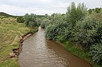 DescriptionCucharas River.JPG English: The Cucharas River in Walsenburg, Colorado. Date 11 August 2017 Source Own work Author Jeffrey Beall...(5,637 × 3,712 (13.92 MB)) - 15:47, 27 April 2024
 DescriptionCucharas River watershed.JPG A broad view of the Cucharas River watershed, taken from the Tres Valles Subdivision in Huerfano County, Colorado...(5,783 × 2,829 (11.9 MB)) - 05:05, 12 June 2023
 DescriptionCucharas River channel cleared.JPG English: A view of the Cucharas River from the Bear Creek Road Bridge in Walsenburg showing the river channel...(4,468 × 4,000 (11.89 MB)) - 15:47, 27 April 2024
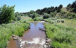 DescriptionCucharas River at Valley Road.JPG A view of the Cucharas River in Huerfano County, Colorado. The view is from a bridge on Valley Road (Huerfano...(5,789 × 3,675 (19.75 MB)) - 15:47, 27 April 2024
 DescriptionCucharas Canyon looking west.JPG English: Looking across Cucharas Canyon from the east side towards Greenhorn Mountain. The Cucharas River can be...(6,000 × 4,000 (16.37 MB)) - 15:47, 27 April 2024
 Site of Cucharas Stage Station on Cucharas River, About Six Mile East of Walsenburg ( ) Creator InfoField Department of Commerce. Bureau of Public Roads...(6,858 × 5,076 (6.69 MB)) - 17:26, 31 March 2024
 com/photos/internetarchivebookimages/20354646416/ operator: Flickr URL: https://live.staticflickr.com/3733/20354646416_ebe4f99933_o.jpg determination method: SHA-1...(2,158 × 1,616 (762 KB)) - 17:28, 13 June 2024
 dam and head gate.JPG The headgate and diversion dam for the Holita Ditch in Walsenburg, Colorado. The river is the Cucharas River. Date 2 March 2022...(6,000 × 4,000 (11.38 MB)) - 22:34, 3 March 2022
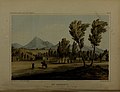 economical route for a railroad from the Mississippi River to the Pacific Ocean (1855) (14573154417).jpg English: Identifier: reportsofexplora02unit_0 (find...(3,904 × 2,990 (1,022 KB)) - 06:00, 25 November 2022
 economical route for a railroad from the Mississippi River to the Pacific Ocean (1855) (14759276642).jpg English: Identifier: reportsofexplora02unit_0 (find...(3,837 × 2,672 (1.33 MB)) - 12:16, 30 August 2024
 point beyond the rail tracks, the creek has its confluence with the Cucharas River, of which it is a tributary. Date Taken on 7 July 2022 Source Own work...(5,263 × 3,806 (17.88 MB)) - 08:34, 7 June 2023
 volunteers.JPG English: Team Rubicon volunteers Erik Bumguardner (left) and Stephen Seminole (right) pause while working on clearing the Cucharas River channel...(4,683 × 3,533 (10.19 MB)) - 07:03, 1 August 2021
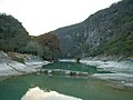 DescriptionRíos y balnearios (12058750213).jpg Ríos y balnearios; Cañón de la Servilleta Date 26 January 2008, 19:26 Source Ríos y balnearios Author Comisión...(800 × 600 (327 KB)) - 14:24, 15 July 2024
 RIO GRANDE WESTERN RAILROAD, CITY LIMITS; (E) CITY LIMITS, CUCHARAS RIVER; (S) CUCHARAS RIVER, CITY LIMITS; (W) MAIN; ALSO ST. MARY S SCHOOL. CO ED 28-10:...(5,143 × 3,079 (1,015 KB)) - 04:37, 9 January 2024
 . Concord ia \i?S **AV Siott Ransom Puebl Salh f «.* v/f 7 ?x Im ;f w CucharaH ^JT AiiloinlM J^tfriiiiilart -.«. ^\ o K^L ^L^d^yKv I IHdcSerfdcncc. /I...(2,932 × 1,290 (1.05 MB)) - 10:03, 8 July 2024
 Colorado. From Pueblo, by way of the Denver and Rio Grande Railroad, toCucharas, and then pass over the Sangre de Christo range, by wayof the Veta Pass ;...(2,664 × 1,760 (1.41 MB)) - 18:37, 8 July 2024
 Yeta is situated at an elevation of6,970 feet, on the south branch of CucharaCreek, at the northern base of the moun-tains, with the Spanish or *Twin...(2,116 × 1,976 (1.35 MB)) - 14:04, 25 April 2024


_(20354646416).jpg)

_(14573154417).jpg)
_(14759276642).jpg)


.jpg)

_(14780824003).jpg)
.jpg)
.jpg)