
File:Cartlinearlarge.png
No higher resolution available.
Cartlinearlarge.png (701 × 448 pixels, file size: 185 KB, MIME type: image/png)
| This is a file from the Wikimedia Commons. Information from its description page there is shown below. Commons is a freely licensed media file repository. You can help. |
Summary
| Description |
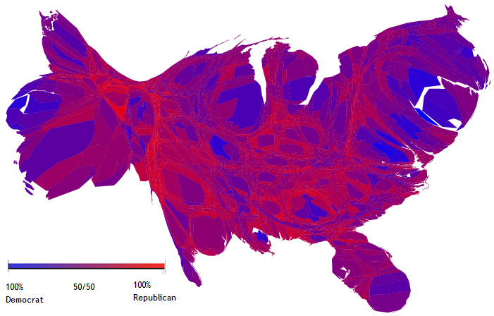
English: A cartogram depicting popular votes in the 2004 US Presidential election, in which the sizes of counties have been rescaled according to their population. |
| Date | 9 November 2004 (original upload date) |
| Source | http://www-personal.umich.edu/~mejn/election/ |
| Author | Created by Michael Gastner, Cosma Shalizi, and Mark Newman of the University of Michigan. |
| Other versions | File:Countycartlinear1280x1024.png |
Licensing
This file is licensed under the Creative Commons Attribution 2.0 Generic license.
Attribution: M. E. J. Newman
- You are free:
- to share – to copy, distribute and transmit the work
- to remix – to adapt the work
- Under the following conditions:
- attribution – You must give appropriate credit, provide a link to the license, and indicate if changes were made. You may do so in any reasonable manner, but not in any way that suggests the licensor endorses you or your use.
This file, which was originally posted to
http://www-personal.umich.edu/~mejn/election/2008/, was reviewed on 29 January 2011 by reviewer Kelly, who confirmed that it was available there under the stated license on that date.
|
Original upload log
The original description page was here. All following user names refer to en.wikipedia.
- 2005-10-19 03:55 Kyorosuke 701×448× (189341 bytes) Reverted to earlier revision
- 2005-10-19 03:54 Kyorosuke 701×448× (186897 bytes) Reverted to earlier revision
- 2005-08-09 20:07 JDoorjam 701×448× (189341 bytes) Reverted to earlier revision
- 2004-11-11 23:47 Ed g2s 701×448× (186897 bytes) cleanup key
- 2004-11-09 13:50 Jacoplane 701×448× (189341 bytes) Reverted to earlier revision
- 2004-11-09 13:50 Jacoplane 701×448× (185095 bytes) Reverted to earlier revision
- 2004-11-09 13:49 Jacoplane 701×448× (189341 bytes) add color description
- 2004-11-09 12:05 Jacoplane 701×448× (185095 bytes) a cartogram, a map in which the sizes of states have been rescaled according to their population.
File history
Click on a date/time to view the file as it appeared at that time.
| Date/Time | Thumbnail | Dimensions | User | Comment | |
|---|---|---|---|---|---|
| current | 07:54, 2 June 2010 | | 701 × 448 (185 KB) | File Upload Bot (Magnus Manske) | {{BotMoveToCommons|en.wikipedia|year={{subst:CURRENTYEAR}}|month={{subst:CURRENTMONTHNAME}}|day={{subst:CURRENTDAY}}}} {{Information |Description={{en|A en:cartogram depicting popular votes in the en:2004 US Presidential election, in which th |
File usage
The following pages on the English Wikipedia use this file (pages on other projects are not listed):
Global file usage
The following other wikis use this file:
- Usage on ar.wikipedia.org
- Usage on hi.wikipedia.org
- Usage on ja.wikipedia.org
- Usage on uk.wikipedia.org
- Usage on zh.wikipedia.org