
Coronado Butte
| Coronado Butte | |
|---|---|
 | |
| Highest point | |
| Elevation | 7,162 ft (2,183 m)[1] |
| Prominence | 1,122 ft (342 m)[1] |
| Parent peak | Sinking Ship (7,344 ft)[2] |
| Isolation | 1.25 mi (2.01 km)[2] |
| Coordinates | 36°00′14″N 111°56′37″W / 36.0038420°N 111.9435129°W[3] |
| Geography | |
 Coronado Butte Location in Arizona  Coronado Butte Coronado Butte (the United States) | |
| Location | Grand Canyon National Park Coconino County, Arizona, US |
| Parent range | Coconino Plateau[1] Colorado Plateau |
| Topo map | USGS Cape Royal |
| Geology | |
| Type of rock | sandstone, siltstone, mudstone |
| Climbing | |
| First ascent | 1890s |
| Easiest route | class 3+ scrambling[2] |
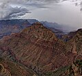
Coronado Butte is a 7,162-foot (2,183 m)-elevation summit located in the Grand Canyon, in Coconino County of Arizona, United States.[3] It is situated one mile (1.6 km) west of the Moran Point overlook on the canyon's South Rim, and one mile northeast of Sinking Ship, its nearest higher neighbor. Topographic relief is significant as this butte rises 4,600 feet (1,400 m) above the Colorado River in 2.5 miles (4.0 km). Coronado Butte is named for Francisco Vázquez de Coronado (1510–1554), the explorer whose 1540 expedition was the first European sighting of the Grand Canyon, among other landmarks.[4] This geographical feature's name was officially adopted in 1906 by the U.S. Board on Geographic Names.[3] The first ascent was made by John Hance and tourist prior to 1900, in the 1890s.[5] According to the Köppen climate classification system, Coronado Butte is located in a cold semi-arid climate zone.[6]
Geology
The summit of Coronado Butte is composed of cream-colored, cliff-forming, Permian Coconino Sandstone with a Kaibab Limestone caprock.[7] The sandstone, which is the third-youngest of the strata in the Grand Canyon, was deposited 265 million years ago as sand dunes. Below the Coconino Sandstone is slope-forming, Permian Hermit Formation, which in turn overlays the Pennsylvanian-Permian Supai Group. Further down are strata of Mississippian Redwall Limestone, and Cambrian Tonto Group.[8] Precipitation runoff from Coronado Butte drains north into the nearby Colorado River.
Gallery
-
 South aspect
 -
 Coronado Butte centered, with parent Sinking Ship to left
 -
 Viewed from near the Buggeln picnic area
 -
 Coronado Butte from Moran Point
 -
 Sunset on Coronado Butte
 -
 East aspect, from Moran Point


See also
References
- ^ a b c "Coronado Butte, Arizona". Peakbagger.com. Retrieved 2021-01-01.
- ^ a b c "Coronado Butte – 7,162' AZ". Lists of John. Retrieved January 1, 2021.
- ^ a b c "Coronado Butte". Geographic Names Information System. United States Geological Survey, United States Department of the Interior. Retrieved 2021-01-01.
- ^ Gregory McNamee, Grand Canyon Place Names, 1997, Mountaineers Publisher, ISBN 9780898865332, page 39.
- ^ John Annerino, 'Hiking the Grand Canyon", 2017, Simon & Schuster, ISBN 9781510714984
- ^ Peel, M. C.; Finlayson, B. L.; McMahon, T. A. (2007). "Updated world map of the Köppen−Geiger climate classification". Hydrol. Earth Syst. Sci. 11. ISSN 1027-5606.
- ^ N.H. Darton, Story of the Grand Canyon of Arizona, 1917, page 63.
- ^ William Kenneth Hamblin, Anatomy of the Grand Canyon: Panoramas of the Canyon's Geology, 2008, Grand Canyon Association Publisher, ISBN 9781934656013.
External links
- Weather forecast: National Weather Service