
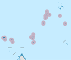
Assumption Island
Nickname: Île de l'Assomption | |
|---|---|
 Assumption Island | |
 Assumption Island Location of Assumption Island in Seychelles | |
| Geography | |
| Location | Indian Ocean |
| Coordinates | 09°45′S 46°29′E / 9.750°S 46.483°E |
| Archipelago | Seychelles |
| Adjacent to | Indian Ocean |
| Total islands | 1 |
| Major islands |
|
| Area | 11.60 km2 (4.48 sq mi) |
| Length | 6.7 km (4.16 mi) |
| Width | 2.9 km (1.8 mi) |
| Coastline | 17.23 km (10.706 mi) |
| Highest elevation | 32 m (105 ft) |
| Highest point | southeast hill |
| Administration | |
Seychelles (leased by India) | |
| Group | Outer Islands |
| Sub-Group | Aldabra Group |
| Districts | Outer Islands District |
| Largest settlement | Assumption (pop. 20) |
| Demographics | |
| Population | 20 (2016) |
| Pop. density | 1.7/km2 (4.4/sq mi) |
| Ethnic groups | Creole, French, East Africans, Indians. |
| Additional information | |
| Time zone | |
| ISO code | SC-26 |
| Official website | www |
Assumption Island is a small island in the Outer Islands of Seychelles north of Madagascar, 1,135 km (705 mi) southwest of the capital, Victoria.
In 2018, Seychelles and India signed an agreement to build and operate a joint military facility on a portion of the island. The Seychelles National Assembly refuted the agreement after protests by the citizens. As protests continued, the Seychellois president endorsed the Assumption Island deal with India.[1][2][3] The plan caused public protests by activists who believed that the islands should stay out of the brewing India-China regional conflict. The agreement was declared "dead" by the Island's opposition party.[4]
History
Assumption Island was discovered by Captain Nicolas Morphey on 14 August 1756, and was named after the religious feast of the next day. In 1908, the island was leased to Mr H. Savy of Mahé, who built a coconut plantation there. The first settlement was in the northern part of the island.[5] During a visit two years later, he realized the guano potential of the island. The villagers transferred their labor force to a guano mining camp that operated from 1907 until 1983. The camp was the location of the current village. Later, the villagers were employed as fishermen, usually of bêche-de-mer, until it was declared protected.
In the mid-1960s, the island was proposed as an American military base, including a deep-sea port. After strong protests from environmental organizations, the plan was rejected. In 1990, the airfield was built.[6]
Geography
Assumption Island is located about 27 km south of Anse Takamaka on Aldabra Atoll and is part of the Aldabra Group. It is a single coral island 11.6 km2 (4.5 sq mi) in area. The western shore features an almost uninterrupted sandy beach 5.5 km. Two large sand dunes are prominent on the southeastern coast of the island, one of them 32 metres (105 ft) high.[7] The 5.5 km, white, sandy beach that stretches on the southeastern side of the island has been several times named 'the best beach in the world' for its white sand, crystalline waters, diversity of marine life and lack of crowds. Due to the disruptive effect of guano mining which lasted until 1983, the island is dominated by expanses of bare rock and caves, and is sparsely covered with low-growing vegetation.
Administration
The island belongs to the Outer Islands District.[8]
Transport
The island is bisected by a 1,210 metres (3,970 ft) concrete airfield (ICAO: FSAS) running between the two sand dunes on the southeast point to the village on the western coast. The island is occasionally serviced by an Island Development Company (IDC) aircraft from Mahé,[9] usually with scientists which have a boat take them to Aldabra Atoll.[10] The island has a small port called St. Thomas Anchorage, which is currently enlarged by the Indian Army to a large port.[11]
Joint Military Facility
Assumption Island Airport | |||||||||||
|---|---|---|---|---|---|---|---|---|---|---|---|
| Summary | |||||||||||
| Airport type | Private | ||||||||||
| Owner | Seychelles | ||||||||||
| Operator | Islands Development Corporation (IDC)[12] | ||||||||||
| Location | Assumption Island, Seychelles, Africa | ||||||||||
| Built | 1989–1990; Major extensions 2015–2016 | ||||||||||
| In use | 1990–present | ||||||||||
| Elevation AMSL | 10 ft / 3 m | ||||||||||
| Coordinates | 9°44′32″S 46°30′24″E / 9.74222°S 46.50667°E | ||||||||||
| Map | |||||||||||
Assumption Island Airstrip Location of Assumption Island  Assumption Island Airstrip Assumption Island Airstrip (Indian Ocean) | |||||||||||
| Runways | |||||||||||
| |||||||||||
In 2015, Seychelles and India signed an agreement for constructing and operating joint military facility on the Island.[13][14][15][16] A coast surveillance radar system built by support from India became operational in 2016.[17][18] A revised agreement was signed in 2018 and the Seychelles President has endorsed its ratification.[19] The Government of India has also stated that this was a joint project on the request of the Seychelles government and would be jointly managed by both countries.[20] India plans to invest $550 million in building the facility.[21] Recently, the deal for an Indian military base in Seychelles was declared as ‘dead’ by the Island's opposition party. The leader of the opposition also clearly stated that this was the end of the ‘assumption agreement’ and no further discussions on India's military base were on the agenda.[22]
Flora and fauna
Assumption Island was once home to a great diversity of seabirds, including the Abbott's booby,[23] which is now confined to a single breeding island: Christmas Island, in the eastern Indian Ocean. Seychelles Islands Foundation, in conjunction with Island Conservation Society and the Islands Development Company, have eradicated two introduced bird species, Madagascar fody and red-whiskered bulbul.[24] A notable feature of this island is the Assumption Island day gecko, a subspecies of gecko found only on this island. An endemic race of souimanga sunbird breeds on the island.[25] The nature documentary of Jacques-Yves Cousteau and Louis Malle, The Silent World was partially shot on Assumption.[26] The island is known for its rich fish life.[citation needed]
Image gallery
-
 Map 1
Map 1 -
 District Map
 -
 Assumption Island
 -
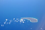 Assumption Island with its runway
 -
 Assumption Island closer look


.jpg)


References
- ^ Bhattacherjee, Kallol (23 December 2015). "'Seychelles committed to Indian naval base'". The Hindu.
- ^ "Asia's scramble for Africa". The Economist. 13 August 2016.
- ^ "India to form its first Naval Base in Seychelles to tighten vigil over Indian Ocean: Read to know more : Current Affairs".
- ^ Desk, EurAsian Times (22 March 2018). "Is China Against the Expansion of Indian Military Base in Seychelles?". EurAsian Times: Latest Asian, Middle-East, EurAsian, Indian News. Retrieved 19 March 2020.
- ^ Atoll research bulletin
- ^ "Welcome to the Official Destination Website for the Seychelles Islands – Assumption".
- ^ This sand dune is much lower today, as it is being dredged for the airport expansion by India and construction of the new naval base
- ^ District map
- ^ "Aldabra Atoll + Islands". 19 February 2013. Archived from the original on 23 April 2016. Retrieved 11 April 2016.
- ^ "Seychelles Islands Foundation".
- ^ Port info
- ^ "Islands Development Corporation". Archived from the original on 12 July 2013. Retrieved 12 July 2013.
- ^ "India begins infrastructure work on Assumption Island of Seychelles". Business Standard. IANS. 26 August 2015.
- ^ Bhattacherjee, Kallol (23 December 2015). "'Seychelles committed to Indian naval base'". The Hindu.
- ^ "Asia's scramble for Africa". The Economist. Retrieved 12 March 2018.
- ^ Laurence, Daniel (16 February 2018). Bonnelame, Betymie (ed.). "Military agreement will benefit both Seychelles and India, high commissioner says". Seychelles News Agency. Retrieved 14 March 2018.
- ^ Bonnelame, Betymie (22 March 2018). "New coastal radar system means better safeguards for Seychelles, official says". Seychelles News Agency. Retrieved 12 March 2018.
- ^ Article 03.2016
- ^ "As Protests Continue, Seychelles President Endorses Assumption Island Deal With India – South Asia Journal". southasiajournal.net. Retrieved 12 March 2018.
- ^ "Assumption Island Project in Seychelles is a joint project: MEA". The Times of India. Retrieved 12 March 2018.
- ^ "Planned Indian military base stirs Seychelles controversy". The Indian Express. 3 March 2018. Retrieved 12 March 2018.
- ^ "Is China Against the Expansion of Indian Military Base in Seychelles?". 22 March 2018.
- ^ Administrator, IDC. "Flora and Fauna – Assumption Island". Archived from the original on 19 March 2016. Retrieved 11 April 2016.
- ^ "Eradication success – Seychelles wins war against invasive red-whiskered bulbul".
- ^ "Other outer islands". Archived from the original on 24 June 2016. Retrieved 11 April 2016.
- ^ Island guide Archived 2016-04-13 at the Wayback Machine
